Evolution of Block 66 in Downtown Fredericksburg: A Historical Perspective
This paper examines the historical evolution of Block 66 in downtown Fredericksburg from the 19th to the mid-20th century, highlighting significant changes in buildings, land use, and societal meaning. By analyzing fire insurance maps, aerial photographs, city directories, and historic photographs, we explore the transformation of this block over time. Key moments include its development in the late 1800s, changes due to urbanization, and the impact of the automobile on local life. Ultimately, the study provides insights into the broader historical narrative of Fredericksburg through the lens of Block 66.

Evolution of Block 66 in Downtown Fredericksburg: A Historical Perspective
E N D
Presentation Transcript
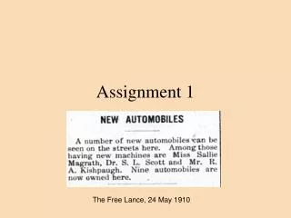
Assignment 1 The Free Lance, 24 May 1910
What’s the deal? Write a paper describing the changes over time [evolution] to block 66 of downtown Fredericksburg. • Changes in buildings • Changes in use of space • Changes in meaning Summarize/Characterize these changes in a short paper.
Putting the pieces of historical knowledge together 1912 1864 1927 1881 1939
Resources • Visual inspection of the buildings on the block at this time. • Fire insurance maps from 1886, 1892, 1896, 1902, 1907, 1912, 1919, 1927, 1937-1947, 1956, 1965 • Land tax map for 1930 • Aerial photographs 1937, current (Google maps, city of Fredericksburg) • Historic pictures, 1881, 1927. Post cards in city library collection. • City directories, 1888-1889, 1892, 1910, 1920, 1938, 1941, 1944, 1947, 1950, 1951 • Manuscript census of 1900, 1910, 1920, 1930. • Newspaper accounts, 19th and 20th centuries. • Land tax records and other documents
Sanborn--1912 Sanborn ---1965
Symbols Abbreviations
Merged stereoptican pictures from St. George’s steeple ca 1881.
Suggestions Don’t write a history of each building. Characterize the changes on the block, then use an example from your research as evidence. Be certain to look at all the fire maps, so you see the changes that may explain features on the block that don’t make sense otherwise. What is driving the changes? Talk about how the town changes, but only from the perspective of this block. How did the automobile impact life? For example. Edit your work.