Download
1 / 43
430 likes | 578 Views
Hydrologic Model of the Mayag üe z Bay Watersheds: Progress Report. Eric Harmsen, Associate Professor Dept. of Agricultural and Biosystems Engineering Marcel Giovanni Prieto, Graduate Student Dept. of Civil Engineering and Surveying. Acknowledgements. NASA-EPSCoR US Geologic Survey

E N D
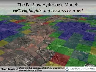
Hydrologic Model of the Mayagüez Bay Watersheds: Progress Report Eric Harmsen, Associate Professor Dept. of Agricultural and Biosystems Engineering Marcel Giovanni Prieto, Graduate Student Dept. of Civil Engineering and Surveying
Acknowledgements • NASA-EPSCoR • US Geologic Survey • Sea Grant • U.S. Army Corps of Engineers (ERDC) • LARSIP Laboratory • Puerto Rico Water Resources and Environmental Research Institute • Professor Nazario Ramirez, UPRM • Students: Sandra Ortiz, Richard Diaz, Moises Angeles Malaspina, Christian Calderon
Some Water Issues in Puerto Rico • Water conflicts between agricultural and non-agricultural community (Lajas, PR) • Sediment transport is contaminating marine resources at numerous coastal areas in PR • Saltwater intrusion is threatening groundwater resources in the north and south coast of PR • Dropping groundwater elevations occurring in the South Coast. • Many of the principal reservoirs have become partially filled with sediment since their construction, reducing their effectiveness in providing water supplies and mitigating flood peaks.(e.g., Carraízo Reservoir which supplies San Juan) • Problems with the water supply service of 700,000 families at the present time in the island (Nuevo Día05 Feb. 2005)
Rio Grande de Anasco Outlet Sediment Discharge to the Mayagüez Bay
Water related issues will become even more serious in the future • Potential climate change • Urban growth • Increasing population • Increasing cost of water and energy • Contamination of water supplies • Environmental impacts from changing flows
Objective • To develop an integrated hydrologic model for the Mayaguez Bay Watersheds for the purpose of • Estimating the components of the hydrologic cycle • Evaluate the water balance under climate change conditions (uncoupled) • Longer-term objectives: • Apply an integrated hydrologic model coupled with a regional atmospheric model (e.g., RAMS/TOPMODEL) • Evaluate the water balance for the entire island
MOTIVATIONWe will be able to address scientific and practical questions related to the hydro/atmospheric system • How might changes in global/local weather affect our water supply • How will urban growth effect the hydrology (land use change, Urban Head Island effect) • Evaluate the effect of specific types of storms on • Flooding • Landslide potential
Modeling Strategy • Multi-watershed model (short-term) • Develop and calibrate hydrologic model • Use output from climate change simulations from an atmospheric simulation model as input to the hydrologic model • Island-wide model (long-term) • Develop and calibrate hydrologic model • Hydrologic model coupled with RAMS
Qualification Model will be developed based on a rough calibration • Available groundwater elevations • USGS gauging station – Total daily volume (not hydrographs) • Overland flow only (no channel flow)
Model Selection Requirements • Should simulate • Overland flow • Vadose zone flow • Groundwater flow (preferably in 3-D) • 1-D channel flow • Should run on a supercomputer • Source code should be freely available Models we evaluated: • Mike She, WASH123D, IHM, GHSSA
Conceptual model development • Identification of data sources • Delineation of study area • Conceptualize surface, soil and subsurface systems • Development of GIS map • Perform simplified GIS water balance
Study Area • Requirements • Two or more watersheds • Boundary along coast • Large topographic relief • Include alluvial and bedrock aquifers • Various land use categories
GIS Water Balance of the Mayaguez Drainage Basin Precip = ET + RO + Rch +ΔS Precip = Precipitation ET = Evapotranspiration RO = Surface Runoff Rch = Aquifer Recharge ΔS = Change in soil moisture storage
Potential Evapotranspiration • Hargreaves-Samani Method PET = 0.0023 x Ra x (T +17.8) x (Tmax – Tmin)0.5 PET = potential or reference ET Ra = extraterrestrial evapotranspiration T = average daily air temperature Tmin = average daily minimum temperature Tmax = average daily maximum temperature
Hydrologic Model - Evapotranspiration Evaluation of Simplified Method Surface Elevation Air Temperature Reference Evapotranspiration
Hydrologic Model - Evapotranspiration Actual ET September Kc Literature Reference ET X NDVI Actual ET January
Hydrologic Model – Surface Runoff LAND COVER MONTHLY RUNOFF COEFFICIENT MONTHLY RAINFALL MONTHLY RUNOFF
Aquifer Recharge September January Aquifer Recharge was zero at all locations 59.7 mm Average
Global Warming http://www.gfdl.noaa.gov/~tk/climate_dynamics/fig1.gif
PET = 0.0023 x Ra x (T +17.8) x (Tmax – Tmin)0.5 “ There has also been a general trend toward reduced diurnal temperature range, mostly because nights have warmed more than days.” - Union of Concerned Scientists http://www.ucsusa.org/global_warming/science/early-warning-signs-of-global-warming-heat-waves.html
Global Climate Circulation Model – Caribbean Area DOE - Accelerated Climate Prediction Initiative
Conclusions from GIS Water Balance Analysis During the next 50 to 100 years: • ET can be expected to increase by 3 to 5 mm/month • In the worse case the aquifer recharge will also drop by this amount • The expected drop in the water table is between 13 to 27 mm. • Increase urban development may decrease aquifer recharge and increase surface runoff.
Numerical Model • MIKE SHE • Advantages • Easy to use • 3-D groundwater • Water balance analysis tools are excellent • Can simulate other processes: sediment and solute transport • Disadvantages • Only runs on a PC • Documentation is not complete OLF – Diffuse wave approximation of the Saint Venant equations UZ – Richards Equation, gravity method, 2 layer water balance SZ – standard groundwater equation (MODFLOW)
Simulation of average conditions for Mayaguez Bay Area • Rainfall – Time series for Hacienda Constanza weather station • Manning’s n: 0.07 • Soil: Loamy Clay • Potential ET: 4.4 mm/day • Aquifer • type: unconfined • thickness: 33 m • conductivity: 0.33 m/day • Initial groundwater elevation: 0 m below surface
Future Work • Model Calibration • Groundwater elevations • Daily Surface water Volumes • Climate Change scenarios • Decide which climate parameters to vary • Write Proposals for more funding (NASA-NEWS)