Download
1 / 29
290 likes | 393 Views
Long Lead Flood Forecast Application to Benefit Society: Experience of 2007 Bangladesh Floods. S.H.M. Fakhruddin Technical Specialist, EWS fakhruddin@adpc.net. Flood Defense 2008, Toronto, Canada, 6-8 May 2008. Presentation Outline. Background- The CAFB project Institutional Mechanism

E N D
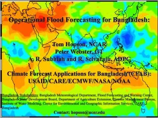
Long Lead Flood Forecast Application to Benefit Society: Experience of 2007 Bangladesh Floods S.H.M. Fakhruddin Technical Specialist, EWS fakhruddin@adpc.net Flood Defense 2008, Toronto, Canada, 6-8 May 2008
Presentation Outline • Background- The CAFB project • Institutional Mechanism • Hazard Detection/Data Collection • Warning Products • Baseline Assessment • Dissemination • Community Response
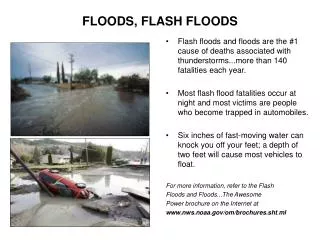
CFAB- The Project • Following the disastrous 1998 flooding when, without warning, flooding from both the Ganges and Brahmaputra covered 60% of Bangladesh for 3 months, the CFAB project was instigated. • Also motivated by shorter term flooding that occurs most years but with sufficiently irregularity to be very disruptive • India provides no upstream data to Bangladesh • Purpose, extend the 2 days forecasts of FFWC to 1-10 days, 20-30 days and seasonal Probabilistic forecast to allow proper risk assessment
The CFAB Project Goals • Develop resilient forecast schemes that capitalize on skillful modeling techniques and advanced data sources at time-scales: • 1-6 months, 20-25 days, 1-10 days (2000) • Develop an infrastructure within Bangladesh to: • a) make use of the forecasts -- establish pilot projects at selected sites, showing measurable improvements (2006) • b) eventually own the prediction schemes -- facilitate a technological transfer (2008)
Institutional Collaboration For Sustainable End-to-end Generation and Application of Flood Forecasts
Discharge Forecast Schemes (I). Initial Data Input (II). Statistical Rendering (III). Hydrological Modeling (IV). Generation of Probabilistic Q (V). Forecast Product • Hydrological Model • Lumped • Distributed • Multi-Model Discharge Forecasting • Accounting for uncertainties • Final error correction • Generation of discharge forecast PDF • Critical level probability forecast Discharge data Hydrologic model parameters NOAA and NASA (i.e.CMORPH and GPCP) satellite precipitation & GTS rain gauge data ECMWF Operational ensemble forecast Downscaling of forecasts Statistical correction
Initial Data Input Initial data comes from a number of sources and is used to either drive the forecasts (e.g.,ECMWF EPS), correct the forecasts and provide calibration of the basin discharge Data is passed on for statistical rendering and to force the hydrological models
Current Status: Interlinked activities in FFWC on daily basis CFAB forecast information integration
Brahmaputra Discharge Forecasts 20071-10 day flood forecasts using ECMWF precipitation forecasts
2007 Brahmaputra Ensemble Forecasts and Danger Level Probabilities 7-10 day Ensemble Forecasts 7-10 day Danger Levels 7 day 8 day 7 day 8 day 9 day 10 day 9 day 10 day
Short-term 7-days Flood Forecasts for Brahmaputra and Threshold Probabilities Summary of forecasts and exceeding of danger level
Plumes and probability pies for the first Brahmaputra flood July 28-August 6, 2007 High probabilities of exceedance of the danger level by the Brahmaputra at the India-Bangladesh border
Plumes and probability pies for the first Brahmaputra flood September 8-16, 2007 For the second flooding, short-term forecasting, successful in providing high probabilities of exceedance of the danger level by the Brahmaputra
Flood risk management at community level decisions and forecast lead time requirement (Eg. Rajpur Union, Lalmunirhat district)
Disasters, impacts and management plan matrix for crop, livestock and fisheries sector (eg. Uria, Gaibandha district)
Institutional and community responses on 2007 flood forecast Discussion of options with local communities, CBOs, local working group members, networks Incorporated into customized local model Communication to Disaster Emergency Group Flood forecast issued for two boundary locations Communication to project partners Information to relief agencies about the extent of flooding Communication to stakeholders and local DMC members 24 Jul 25 Jul 26 Jul 30 Jul 2 Aug 21 Jul 22 Jul 23 Jul Relief distribution started in affected locations Local Disaster Management Committee and Volunteers prepared for rescue Community in low lands reserved their food, drinking water, fodder requirements Aid agencies arranged logistics and begin dialogue with district administration Local institutions prepared response and relief plans Low lying areas are flooded on 29th July Flood water exceeded danger level on 28th July Danger level probability
Response of National institutions:2007 flood forecasts • Flood Forecasting and Warning Center incorporated the CFAB forecasts to produce water level forecasts for many locations along Brahmaputra and Ganges well in advance • National level Disaster Emergency Response Group consisting of INGOs, Ministry of Food and Disaster Management and International Organisations prepared emergency response plans, logistics for preparedness and relief in advance • National level NGO network and INGOs prepared localised warning messages and disseminated to their counterparts at local level • National level service organisations like Department of Agriculture Extension prepared rehabilitation plans in advance
Response of local institutions for 2007 flood forecasts • District level service organisations in partnership with NGOs communicated 1-10 days forecast in 5 days advance • Local NGOs and implementing partners prepared evacuation and response plans to protect lives and livelihoods • District level relief and emergency orgnisations plan to mobilise resources for relief and recovery activities • Local NGOs, Government organisations and CBOs mobilise mechanised and manual boats to rescue people and livestock from the “char” areas • Local NGOs and Department of agriculture extension prepared work plan for relief and rehabilitation activities
Community level decision responses for 2007 flood forecasts (Low lands) • Local people planned to store dry food and safe drinking water for about 15 days knowing that relief will start only 7 days after initial flooding. • Secured cattle, poultry birds, homestead vegetables, protected fishery by putting nets in advance • Secured cooking stove, small vessels, firewood and animal dry fodder • Planed to evacuate and identified high grounds with adequate sanitation and communication • Planed for alternative livelihood options immediately after flooding (eg. Small scale fishing, boat making)
Community level decision responses for 2007 flood forecasts (High lands) • Abandoned T. aman transplanting temporarily anticipating floods • Secured additional seedlings for double planting of rice after the floods • Protected homestead vegetables by creating adequate drainage facilities • Reserved seeds of flood tolerant crops • Planned for growing seedlings in high lands • Planed for alternative off-farm employment during floods • Early harvesting of B.aman rice and jute anticipating floods • Leaving livestock in high land shelters
Risk Communication- New Generation Location/ Situation Specific Risk Information • Capacity Building of institutional learning process need to take place • New institutional coordination arrangement (i.e. Monsoon Forum) • Downscaling climate forecast product and long range forecasts to manage uncertainty • Training & capacity building