Download
1 / 30
300 likes | 474 Views
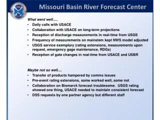
2010 USACE/USGS/NWS Tri-Agency Meeting MVN WATER MANAGEMENT RESPONSE TO THE 2010 DEEPWATER HORIZON OIL SPILL Will Veatch Brainerd, MN October 6 th , 2010. Timeline of Events. 2/15/10: Deepwater Horizon begins drilling at Macond o site. 4/20: Deepwater Horizon explodes.

E N D
2010 USACE/USGS/NWS Tri-Agency Meeting MVN WATER MANAGEMENT RESPONSE TO THE 2010 DEEPWATER HORIZON OIL SPILL Will Veatch Brainerd, MN October 6th, 2010
Timeline of Events 2/15/10: Deepwater Horizon begins drilling at Macond o site 4/20: Deepwater Horizon explodes 4/29: LA declares State of Emergency 4/30: oil sheen ashore near Venice 8/4: Well sealed 6/10: HQUSACE request for info on possible deviation at Old River Complex 5/8: Davis Pond diversion opened 4/28: MVN requests information on all MR diversions 4/27: State requests Bonnet Carre’ opening
Proposed Flow Increases Through River Diversions • 4/27: LA requests operation of Bonnet Carre’ Spillway • MVN and MVD respond that river stage too low for operation • 4/28: MVN-EX requests information on operability and flow rate for all diversions on lower Mississippi River
Proposed Changes to Mississippi River Regulation • 6/10: HQUSACE requests information on increasing Miss. flow at Old River • Effects on Mississippi relatively small • Effects on Atchafalaya relatively large • Most deviations raise head over 22 ft.
15-Day Water Particle Trajectories660K cfs Discharge • The simulation begins with neap tide so particle movement is generally less initially, then increases as spring tide conditions occur • Particles released in Breton sound tend to remain in Breton Sound • Particles released from the 3 east- side passes move into Breton Sound • Once inside Breton Sound, particle movement is to the north toward Chandeleur Sound and not toward Caernarvon wetlands • The Chandeleur Islands are vulnerable in this tide/wind/discharge scenario • Of particles released in the natural tidal channel leading to Breton Sound adjacent to the Bird’s Foot, one of two does not enter the sound • All but one particle released from the east side of the delta enter the sound • Results depend on the wind, tide and discharge conditions and the time within the spring-neap tide cycle when particles are first released
15-Day Water Particle Trajectories1,000K cfs Discharge • 200,000 cfs increase from 800K to 1000K cfs is comparable in magnitude to large deviation in flow at Old River • Particles released in Breton sound tend to remain in Breton Sound, same as 660K and 8080K cases, but move closer to the barrier islands and away from the interior marshes • Particles released in the entrance and along the east-side passes tend to remain outside the barrier islands as they move north then move into the sound further north, a different response than other two cases • Once inside Breton Sound, particle movement is to the north toward Chandeleur Sound, same as in the 660K and 800K cases • The Chandeleur Islands are vulnerable in this tide/wind/discharge scenario, apparently, perhaps more so than in the other two cases • There are more beneficial effects at this discharge level in terms of spill movement into Breton Sound • Influence of this discharge rate on longer-term spill movement toward Mississippi barrier islands has not been examined • Reliability of particle movement near end of the 15-day simulation addressed in next slide
Proposed Modifications to Control Structures • 6/24: Audubon Society requests USACE investigate methods of increasing Mississippi River flow below Old River Complex, beyond 22 ft. limit • 7/2: Construction of Low Sill tailwater dike estimated to take 2 mo., $7M
Conclusions and Lessons Learned • Deepwater Horizon spill an opportunity to inventory water mgt. capabilities • Communication within USACE was quick, with public slower • Public perceptions of diversions, capabilities was informative (+ )
Operation of Mississippi River Freshwater Diversion Structures In Response to the Deepwater Horizon Oil Spill Rodney Mach Hydraulics and Hydrologic Branch U.S. Army Corps of Engineers, New Orleans District Brainerd, MN October 5th, 2010
Two Major Freshwater Diversion Structures on the Mississippi River within MVN • Davis Pond • Caernarvon
Davis Pond • Located at River Mile 118 AHP on the West Bank of the Mississippi River – About 20 miles upriver of New Orleans • Discharges into the Barataria Basin • Project Purpose is to control salinity for the enhancement of fish & wildlife resources • Maximum flowrate is 10,650 cfs
Caernarvon • Located at River Mile 81.5 AHP on the East Bank of the Mississippi River – About 10 miles downriver of New Orleans • Discharges into the Breton Sound Basin • Project Purpose is to control salinity for the enhancement of fish & wildlife resources • Maximum flowrate is 8,000 cfs
Actions to Alleviate Oil Spill’s Impacts • Question came up as to how operation of Davis Pond & Caernarvon could be used to help alleviate the impacts of the oil spill • Rationale was that operating them at max capacity could help to keep the oil from moving as far into the wetlands
Bruce Ebersole’s group at ERDC’s Coastal and Hydraulics Laboratory modeled each of the estuaries • Used a 2-D hydrodynamic model (ADH) to assess potential for spill to move into wetlands • Simulated effects of tide, wind, & diversion discharge on water movement
Simulated water velocities & water particle trajectories using the Particle Tracking Model (PTM) • 2 Operation scenarios considered for each diversion • Diversion Closed • Diversion Open and running at max capacity • Davis Pond – 10,600 cfs • Caernarvon – 8,000 cfs
Particle trajectories were compared for Diversion open at max capacity vs. Diversion closed conditions
No Wind, Tide Only, Diversion Closedat Caernarvon Note penetration of water into the wetland from release points due to tidal action, when the diversion is closed. Particle excursion distances provide an indication of how far into the marsh spill effects might occur with the diversion closed under normal tidal action
No Wind, Tide Only, Diversion Openat Caernarvon No penetration of water into the wetland from most release points when the diversion is open.
No-Wind, Tide-Only Comparison for Caernarvon Yellow line indicates the maximum particle intrusion with diversion closed. Red line indicates the maximum water particle intrusion with the diversion open. Damage of a spill to the outermost fringes of the marsh might be unavoidable, even with the diversion open. Damages are most likely to be avoided by curtailing spill penetration deeper into the marsh. Approximate net acreage protected was crudely estimated as 5,500 acres
No Wind, Tide Only, Diversion Closed at Davis Pond, Group 1 Release Points Particle excursions increasein higher-velocity areas where flow through the wetland is concentrated into a channel, such as at Points 1 and 2. Limited water particle excursions during the 20-day simulation period, such as point 3, indicate very slowly moving water under tidal action alone. The amplitude of back and forth particle excursions associated with tidal action increases as the release point is closer to the source of tide action in Barataria Bay and the Gulf (Point 4).
No Wind, Tide Only, Diversion Openat Davis Pond, Group 1 Release Points Trajectories from the various points indicate that with the diversion open, movement of a spill upstream from Point 4 deeper into the wetland to the north is unlikely under normal low wind, tide-dominant conditions Net movement of water from these critical points is in the seaward direction working against upstream spill movement of any spill that is present in the Bay
Summary of Modeling Results • Operation of the Caernarvon Diversion at max capacity of 8,000 cfs could reduce intrusion of the spill into the adjacent wetlands. • Operation of the Davis Pond Diversion at the max capacity of 10,600 cfs could reduce intrusion of the spill into Barataria Bay under certain conditions.
Operation of Davis Pond and Caernarvon • Structures designed to be operated based on achieving desired salinity conditions • After the spill the State set the flow rates at, or near max capacity, rather than basing the flow rates on achieving desired salinity conditions
Impacts of Diversion Operations • Did operation of the structures at high flow rates alleviate effects of the oil spill? • Impossible to know for sure Did operation of the structures at high flow rates impact salinity conditions? - Most likely