Download
1 / 39
390 likes | 477 Views
Learn about the fundamental concepts of atmospheric pressure and wind dynamics. Explore how air pressure, density, and temperature influence wind patterns worldwide. Understand the roles of pressure gradients, Coriolis effect, and friction in shaping wind behavior. Discover the circulation patterns of the atmosphere, including Hadley cells, trade winds, and polar easterlies.

E N D
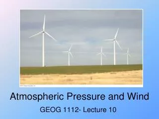
Chapter 5 Atmospheric Pressure and Wind Physical Geography A Landscape Appreciation, 9/e Animation Edition Victoria Alapo, Instructor Geog 1150
Atmospheric Pressure and Wind • Atmospheric Processes • The Nature of Wind • General Circulation of the Atmosphere • Modifications of General Circulation • Localized Wind Systems
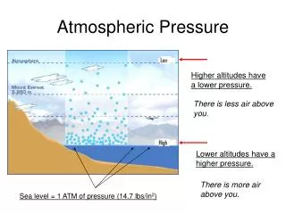
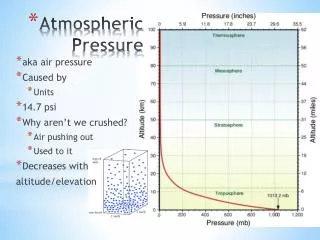
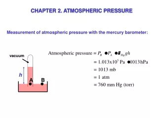
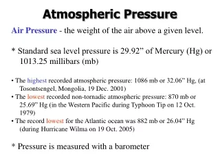
Atmospheric Processes • Atmospheric pressure is the force exerted by gas molecules on some area of the Earth’s surface, including physical bodies. At sea level, it is 14.7 pounds/sq. inch. See Fig 5-2, page 108. • We don’t feel it because we are at equilibrium with nature – the pressure inside of us, is the same as that outside. We only notice it when we leave sea level.
Atmospheric Processes Pressure, Density, and Temperature: • While pressure is directly related to density (proportional), it is inversely related to temperature. • So, the higher the density, the higher the pressure, and vice-versa. So solids are more dense than gases (gases spread). • The lower the temperature of air or water (colder), the higher the pressure; and the higher the temperature (hotter), the lower the pressure. This is because things expand as they get warmer and vice-versa. Sea floors have the highest pressures (why?).
Mapping Pressure with Isobars Isolines all have the same concept. However, unlike contours that stay the same, pressure lines can change with atmospheric conditions. Here, a “ridge” is an ‘elongated area’ of high pressure and a “trough” is an ‘elongated area’ of low pressure. Atmos. pressure is measured with a Barometer. “Millbars” (mb) are now the preferred unit of measurement (metric). At sea level, it is 1013.25 mb.
The Nature of Wind • Direction of Movement caused by: • Pressure Gradient • Coriolis Effect (see chapter 3) • Friction • Wind Speed • Cyclones and Anticyclones
Pressure Gradient Wind is “air in motion”. And air always moves from an area of high pressure to an area of low pressure. This is what causes wind. That’s why Chapter 5 is titled “Air Pressure & Wind” – the 2 go together. It is the “change in pressure” that causes wind. Also, that’s why people can get sucked out of a pressurized plane (high to low pressure).
Wind Speed Same concept as an isoline: lines close together means “steep” pressure or fast, far apart lines means “gentle” pressure or slow. “Pressure gradient” is the spacing of the isobars. *Note the direction of flow. See pg 115 – wind speeds in the U.S. and pg 114 for definition of a “knot”.
Friction Friction is caused by trees, buildings, mountains, hills, etc – anything in the way. It slows air down & changes its direction, causing more turbulence (see figure on right).
Cyclones and Anticyclones Cyclones are low pressure centers (air flows into them) e.g. hurricanes, tornadoes. Also assoc. with clouds (air condenses as it rises). See figure on right. Anticyclones are the opposite; air flows out and are assoc. with clear weather.
General Circulationof the Atmosphere • Hadley Cells – giant convection systems close to the equator. As the warm air rises to about 50,000 ft, it cools and part of the air moves towards the poles, where it descends at about 30 degrees N and S to become the sub-tropical high pressure winds (STHs). The other part moves back to the equator to repeat the process. See next slide.
Components of General Surface Circulation • Subtropical Highs • Trade Winds • Intertropical Convergence Zone • The Westerlies • Polar Highs • Polar Easterlies • Subpolar Lows/Polar Front
Subtropical Highs (STHs) Formed by the high pressure created from descending air of Hadley Cells. They are giant anticyclones (characteristic?) They are persistent, and are found about 30 degrees N & S. Also called the “horse latitudes” (16th & 17th cent.) STHs are the source of Trade Winds & Westerlies.
Subtropical Highs Responsible for the world’s greatest deserts. Dry conditions caused by no uplift of air due to high pressure.
Trade Winds Major wind systems of the tropics, btw latitudes 25 degrees N & S. Dominates the earth more than any other wind system. They are Easterly (blow from East). That’s how winds are named (continued on next page).
General SurfaceCirculation Trade winds are the most reliable of ALL winds – their direction & speed is extremely consistent (whether it be summer, winter, day or night). There is one exception (discussed later). Hence “trade winds”, mean “winds of commerce”. 16th century sailors found that it was the fastest & most reliable route from Europe to America.
Intertropical Convergence Zone (ITCZ) This is where the Trade Winds converge. Known for low pressure & a lot of storms. Also called the “doldrums” (calm air) – even though it’s a zone of convergence, horizontal air flow is weak.
The Westerlies Why are they called “Westerlies”? Found btw 30 to 60 degrees N & S, and originate from the STHs.
Jet Streams Jet streams form the BOUNDARIES of the Westerlies. There are 2 types: polar and subtropical. They are high speed winds, and 60 knots is the minimum to qualify. See Fig 5-24, pg 122. Whenever the paths of jet streams change or meander, they’re called “Rossby Waves”. Fig 5-25, pg 123.
General SurfaceCirculation • Polar Highs • Polar Easterlies • Subpolar Lows/Polar Front
General Surface Circulation • Polar Highs –located over both the N & S poles. Air movement is mainly anticyclonic (divergent, high pressure cold air), hence, “polar highs”. The weather is usually “nice” or rather, “clear”, and this leads to them becoming “polar deserts”. The Antarctic high is more persistent than the Arctic high (that’s why it’s colder in the Antarctic). • Polar Easterlies – located btw the polar highs & latitude 60 degrees N & S. The move from the east, and are very dry. See next slide. • Sub-Polar Lows/ Polar Front – btw 50 and 60 degrees N & S, and it’s a zone a low pressure. Usually contains a polar front (where the cold polar easterlies and the warmer westerlies meet). This results in storms & gale-force winds. See Fig. 5-28, pg 125.
Modifications of General Circulation • Seasonal Variations in Latitude • Monsoons
Localized Wind Systems • Sea and Land Breezes • Valley and Mountain Breezes • Katabatic Winds • Foehn/Chinook Winds
El Niño and La Niña • El Niño Conditions in Pacific Ocean • Related Weather Events (next slide) • La Niña