Currents and Climate
Currents and Climate. Continental Margin. Global Winds. Continents. Salinity. Deep Ocean Basin. Temperature. Upwelling. Continental Rise. Oceans. Ocean Currents. Stream-like movements of ocean water Influenced by; Weather Earth’s rotation Position of continents. Surface Currents.


Currents and Climate
E N D
Presentation Transcript
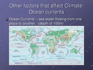
Continental Margin Global Winds Continents Salinity Deep Ocean Basin Temperature Upwelling Continental Rise Oceans
Ocean Currents • Stream-like movements of ocean water • Influenced by; • Weather • Earth’s rotation • Position of continents
Surface Currents • Occur at or near the surface of the ocean • Controlled by; • Global winds • The Coriolis effect • Continental deflection Deep Currents • Located far below the ocean surface • Formed by; • Water density (Temperature and Salinity)
Creates warmer climates The Gulf Stream is an example Maintains cooler coastal temperatures California Current Warm Water vs. Cold Water
Upwelling • Nutrient rich cold water replaces warm surface water • Nutrients provide food for fish and plants • Encourages survival of the ocean ecosystem
To Ponder... • 1. Referring to your graph: • a. Describe the wind direction and speed during the periods of coldest water (maximum upwelling). • b. Describe the wind direction and speed during the periods of warmest water (minimum upwelling). • 2. Why do you think the cold upwelled water is concentrated at the Point Año Nuevo and Point Sur locations? • After discussing upwelling as part of your warm-up, write an explanation for upwelling that a 10 year old could read and understand.
Questions Continued 4. Tour boat operator a. Suppose you were offering bay tours to the public and wanted your patrons to see the large, plankton-eating basking sharks that visit Monterey Bay. What area would be optimal for spotting these sharks close to Moss Landing? Lat. _____°__ & Long._____°__ Why? b. During the summer, there is often a small pod (group) of plankton-eating blue whales south of Monterey. What area would be optimal for whale watching trips departing from Monterey? Lat. _____°__ & Long. _____°__ Why? 5. Power Plant at Moss Landing a. There is a large gas burning electrical power plant at Moss Landing that releases warm water, used for cooling its turbines, into Monterey Bay. Does this warm water show up on the satellite map? Why? b. Would you expect to find this warm water near the surface or on the bottom? Why?