Download
1 / 7
100 likes | 483 Views
Latitude and Longitude. How do we find places on maps?. Latitude. What is Latitude? Lines of Latitude run horizontally Latitude is measured in degrees. The Equator is 0 degrees Latitude. Lines of Latitude locate places North or South of the Equator.

E N D
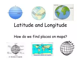
Latitude and Longitude How do we find places on maps?
Latitude What is Latitude? • Lines of Latitude run horizontally • Latitude is measured in degrees. • The Equator is 0 degrees Latitude. • Lines of Latitude locate places North or South of the Equator. • The North Pole is 90 degrees N Latitude, and the South Pole is 90 degrees S Latitude.
Longitude • Lines of Longitude run vertically. • They are also called Meridians. • The Prime Meridian is found in Greenwich, England. • The Prime Meridian is 0 degrees Longitude. • Lines of Longitude locate places East or West of the Prime Meridian. • There are 180 degrees of east Longitude, and 180 degrees of west Longitude.
Time Zones • Time zones are broad strips that measure 15 degrees wide. • Time zones differ from their neighboring time zones by 1 hour. • The continental U.S. has 4 time zones, Eastern, Central, Mountain, and Pacific. • In the Spring we shift the clocks 1 hour ahead. This is called Daylight Saving Time. • In the Fall we shift the clocks 1 hour back.
Time Zones (cont…) Local Time and Universal Time Local Time- is what we use everyday, and regulates our lives. Examples of Local Time are: meal time, sleep time, work time, and school time Universal Time- is what we use when we need a time that is agreed upon marking time world-wide. An example when Universal Time was used was when a supernova in 1987 was first seen. Astronomers, and Astronauts use Universal Time..
Time Zones (cont….) • Greenwich Mean Time- is the time that is registered at Greenwich, England. **Greenwich Mean Time is another name for Universal Time. The International Dateline was established following the 180th meridian, where ever we cross it the date advances 1 day ( if you are going west), or goes back 1 day (if you are going east).
Summary 1.What do lines of Latitude and Longitude combine to make? A grid. 2.Compare and Contrast Latitude and Longitude. Latitude- horizontal, north- south, parallels Longitude- vertical, east-west, meridians 3.What is 0 degrees Latitude? Equator 4.What is 0 degrees Longitude? Prime Meridian 5.How many time zones do we have in the U.S.A.? 4- Eastern, Central, Mountain, Pacific 6. Explain the difference between Local Time, and Universal Time. Local time- used everyday Universal Time- is used for a planetary event, or for astronomy