Download
1 / 20
200 likes | 334 Views
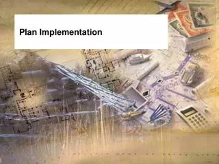
Implementation Plan for the Multipurpose Marine Cadastre. Briefing for the FGDC Coordination Group National Capital Planning Commission 401 9 th Street NW – North Lobby Suite 500 Washington, D.C. March 7, 2006. United States Department of the Interior Minerals Management Service

E N D
Implementation Plan for the Multipurpose Marine Cadastre Briefing for the FGDC Coordination Group National Capital Planning Commission 401 9th Street NW – North Lobby Suite 500 Washington, D.C. March 7, 2006 United States Department of the Interior Minerals Management Service Mapping and Boundary Branch
Introduction The Energy Policy Act of 2005, (Public Law 109-58) was signed into Law on August 8, 2005. Sec. 388 – Alternative Energy-Related Uses on the Outer Continental Shelf, of the Act granted the Minerals Management Service (MMS) new authority to regulate energy uses on the Outer Continental Shelf (OCS). Moreover, it directed the Secretary of the Interior, in cooperation with the Secretary of Commerce, the Commandant of the Coast Guard, and the Secretary of Defense to establish an OCS Mapping Initiative to assist in decision making related to alternative energy uses on the OCS. (Hereinafter MMS is referring to the OCS Mapping Initiative as the Multipurpose Marine Cadastre). The goal of the initiative is the identification of OCS locations of Federally-permitted activities; obstructions to navigation; submerged cultural resources; undersea cables; offshore aquaculture projects; and any area designated for the purpose of safety, national security, environmental protection, or conservation and management of living marine resources.
Background • The Department of the Interior has been conducting offshore leasing and associated mapping activities for over 50 years. • Determine boundaries between Federal and State jurisdictions • Map and define the submerged lands of the United States, including its territories and possessions. • Prepare legal descriptions and convey minerals rights. • Witnessed firsthand the exponential increase in complexities, uses, and problems associated with rights, restrictions, protection, and enforcement on resource development and management. “The development of a multipurpose marine cadastrecannot be performed in a vacuum.”
What’s The Objective In Having A Multipurpose Marine Cadastre? • “The objective behind the development of a “Multipurpose Marine Cadastre” is to provide a comprehensive spatial data infrastructure whereby rights, restrictions and responsibilities in the marine environment can be assessed, administered and managed”. • Provide decision makers at the highest levels of government with the types of quality and timely information necessary to make informed decisions. “Good Ocean Governance!!”
What Should A Marine Cadastre Look Like? • First off, the cadastre must be dynamic. • It must be flexible enough to deal with overlapping authorities, rights, and interests in five distinct layers of the marine environment; the air space, the water surface, the water column, the seabed, and the subsurface. • The cadastre needs to be corporate in its design. • It must be able to adapt and evolve with changes in policy, legal exigencies, reference datum's, technology and the affects associated with those technologies. • It needs to incorporate a grid system, e.g., UTM, PLSS, SPCS.
Competing Uses of the Marine Environment & it’s Resources • Multiple and often Overlapping Rights Native American Rights Air Column Water Surface Navigation Rights Riparian Rights Public Access Rights Water Column Seabed Use Rights Development Rights Fishing Rights Seabed Subsurface Mineral Rights After Sutherland, 2003
1 2 3 6 4 5 7 8 9 NH18-10 11 12 6 Degrees UTM Grid System - Breakdown NH-18 4 Degrees
Block Specifications • Each Regular UTM Block contains 2304 Hectares (5693.285 Ac.). • Each Regular UTM Block is 4800 meters on a side. • Each Regular proposed subdivision, (e.g., 6001A) contains 256 Hectares (632.587 Ac.). • Each Regular proposed subdivision is 1600 meters on a side. • Allows for a unique numbering scheme for each parcel, (e.g., NH18-10 6001A) • Allows for additional equal subdivisions: • ½ = 128 Ha. (316.294 Ac.) • ¼ = 64 Ha. (158.147 Ac.) • ¼ ¼ = 16 Ha. (39.537 Ac.) UTM Block Number 6001 A B C D E F H G I UTM Grid Block
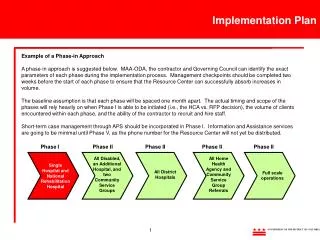
What Are the Necessary Steps In Developing A Multipurpose Marine Cadastre ? • Defining Roles and Responsibilities • Developing A Proactive Approach to Resolving Marine Boundary Issues • Developing A New Mind Set • Establishing Communications • Building Collaborative Partnerships • Developing Standards
Defining Roles and Responsibilities • Roles and responsibilities for managing the U.S. marine environment are distributed throughout numerous Federal department and their subdivisions. • These roles and responsibilities are mandated by a variety of enabling legislations (e.g., Acts, Executive Orders, Presidential Proclamations, etc.) • As civil servants we have a responsibility, as well as a mandate through the Office of Management and Budget’s A-16 circular “to coordinate surveying, mapping and spatial data related activities”. I believe that includes actively looking beyond our immediate roles and responsibilities to determine how these mandates, actions, and data impact other departments. “If there is to be any hope for development of a marine cadastre, then each department must accept their delegated roles and responsibilities and assign the appropriate individuals within those organizations the authority and responsibility to actively engage in the process and work cooperatively towards a common goal.”
Developing A Proactive Approach to Resolving Marine Boundary Issues • Boundary issues cannot be left to the last possible minute to be resolved! • Legal actions are time consuming and expensive, • Except responsibility for assigned authority, • Develop collaborative partnerships, • Develop open honest communication. “The most successful boundary development processes are based on integrity.”
Developing A New Mind Set If a comprehensive marine cadastre is to be developed in a timely and efficient manner then a pervasive mind set existing within Federal, State, and Local Governments must first be overcome. “We have our job and you have yours” Different agencies look at their assigned roles and responsibilities for boundary development as either a protector, as a developer, or maybe evenbothof the marine environment. Agencies with diverse and, at times, conflicting roles and responsibilities should not allow their individual roles and responsibilities to preclude them from working together towards a common interest and goal of doing what is in the overall best interest of the United States which includes all Federal, State and Local Governments. “Good Ocean Governance!!” The Reality today is: “No one places a boundary on the face of the earth, including the marine environment, that doesn’t have an impact on someone else.”
Establishing Communications • Developing communications between all stakeholders, i.e., Federal departments, coastal States, private industry, the academic community, and all other stakeholders, is a critical step in the process. • If a comprehensive marine cadastre is going to be developed and maintained in the most efficient and meaningful manner it will require collaboration and open honest communication among all stakeholders. • We oftentimes “Agree to Disagree” and in so doing respect the other stakeholders position.
Building Collaborative Partnerships • Why develop collaborative partnerships? • Authorities/Responsibilities • Mandates • Limited Funds • Timeliness • Limiting duplication of effort • Access to a broader range of expertise and resources • Successful collaborative partnerships: • Federal Geographic Data Committee (FGDC) • Subcommittees • Working Groups – In particular the FGDC Coastal & Spatial Data Subcommittee’s Marine Boundary Working Group (MBWG) – The MBWG has adopted the MMC as a work item in its 2006 and beyond Work Plan. • Partnerships and Memorandums of Understanding with NOS & coastal States • Ocean Action Plan, Joint Subcommittee for Ocean Science and Technology (JSOST), and the newly formed Interagency Working Group for Ocean and Coastal Mapping (IWGOCM)
Coastline (MLLW) (As approved by the IBLC and Mapped by NOAA) Submerged Lands Act Boundaries (MMS) Limit of “8(g)” Zone (MMS) Territorial Sea (NOS) Contiguous Zone (NOS) EEZ (NOS) Maritime Boundaries/Limits (As defined by the Agency of responsibility (AOR).) Marine Managed Areas (This includes Marine Protected Areas – As defined by the AOR.) UTM Grid System (Defines MMS’s leasing grid system) Official Protraction Diagrams & Leasing Maps (MMS) Location of Leases (MMS) Army Corps of Engineers Permits Sand Borrow Sites Pipeline Routes and Landfall Locations Undersea Cable Routes and Landfall Locations Artificial Reef Sites Shipping Fairways, Anchorage Areas, Traffic Separation Schemes Military Restricted Areas Platform Locations Archeological Sites Coastal State Lateral Boundaries Developing Alternative Energy Sources, e.g., Wind, Wave, Tide, Current Energy, Cooling with Deep Ocean Water Offshore Liquefied Natural Gas (LNG) Facilities No Discharge Zones Habitat & Species Related Information ETC. What Coverage’s Are Necessary For Incorporation Within A Multipurpose Marine Cadastre?For the United States
Thank You! United States Department of the Interior Minerals Management Service Mapping and Boundary Branch