Harry W Nice Memorial Bridge Replacement Projects
50 likes | 68 Views
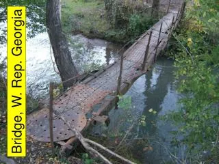
Harry Nice Bridge, also known as the Potomac River Bridge, is a continuous truss bridge with an approximate total length of 10,050 ft that spans the Potomac River between Newburg in Charles County, Maryland and Dahlgren in King George County, Virginia, United States.

Harry W Nice Memorial Bridge Replacement Projects
E N D
Presentation Transcript
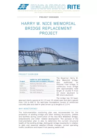
ONE STOP MONITORING SOLUTIONS | HYDROLOGY | GEOTECHNICAL | STRUCTURAL | GEODETIC Over 50 years of Excellence through ingenuity PROJECT DOSSIER HARRY W. NICE MEMORIAL BRIDGE REPLACEMENT PROJECT PROJECT OVERVIEW The Governor Harry W. Nice Memorial bridge, also publicized Potomac river bridge, is continuous truss bridge with approximately total length of 10,050 ft from VA shore abutment to MD shore abutment. HARRY W. NICE MEMORIAL BRIDGE REPLACEMENT PROJECT Newburg, Maryland, USA Project Location as Client Contractor Consultants Foundation Test Group Inc. Skanska Schnabel Engineering Duration Feb-2020-Going on The bridge has 59 lower approach bents spaced at 61.5 ft and 19 raised span and piers spaced from 116 to 800 ft. Its bent/pier foundations consist of reinforced concrete piles and steel H-piles driven up to lengths of 115 ft. WHY MONITORING? The instrumentation monitoring plan was recommended for the protection of existing bridge and other existing structures, utilities and facilities during construction of the new Nice Middleton Bridge, embankments and other related development. The purpose of the instrumentation plan is also to determine the current structural health of the existing bridge, distinguish bridge movements in relation to daily and seasonal weather/climate changes, normal operating traffic conditions and impact from passing watercraft. www.encardio.com
MONITORING SOLUTION Datalogger Rite Geosystems Inc., our USA Company was enstrusted by Foundation Test Group to provide instrumentation and monitoring for the bridge, during pre-construction baseline monitoring and during construction. Scope of works include: Supply of geotechnical instruments Automatic monitoring with compact dataloggers Automatic survey with robotic total stations Online web-based data management system (WDMS) with pre-set alarms Auto generated daily, weekly and monthly reports Strain gage INSTRUMENT USED Existing bridge monitoring Used on girders and trusses for strain measurement Used on trusses measuring tilt/rotations Used to monitor any existing crack and on the epoxy repaired piers Used on piers, decking, girders and trusses to monitor X-Y-Z movements Automatic compact dataloggers with GSM/GPRS modem Automated total station system and in- house developed control box with GSm/GPRS and suitable software to control the total station remotely. Construction works (of new bridge) monitoring Used for monitoring groundwater levels and pore water pressures at land- based foundation construction. To monitor embankments, adjacent structures and retaining walls to verify that movements are within design tolerances Used to monitor sub surface settlement of critical utilities and underground structures near construction To monitor settlement of embankments and adjacent structures to verify that movements are within design tolerances Strain gages and decks for Tilt meters Crack meters Prism targets Datalogger ATS Piezometers lateral movement of In-place Inclinometer Borehole extensometer Settlement points Rite Geosystems Inc. also provided complete online cloud based monitoring solution. www.encardio.com
RESULTS Monitoring of the above-mentioned instruments has beene executed successfully. The real-time data from the strain gages, tilt meters and other sensors installed on the existing bridge are continuously accessible to the consultant/contractor at their desk, during works. This helps the contractor to perform their construction activities safely, without any delays or failure. Wireless Tilt meter Along with generating project instrumentation reports, the software has the provision to give alarms by SMS/email in case any data crosses the pre-set review and alert levels. The near real-time data is helping in the smooth and cost effective progress of construction works. Few screenshot from the online database management system are given below. Google map view of the Harry Nice Bridge from our database management system. Numbers mentioned in the circle signify the number of sensors installed at the particular location www.encardio.com
Our monitoring platform showing location and IDs of instruments installed View of instrument locations on bridge. Quick data (plots) can be viewed here itself by clicking on the desired sensor ID. www.encardio.com
X-Y-Z deformation data from automatic total station Tilt meter and temperature data ENCARDIO-RITE ELECTRONICS PVT. LTD. A-7, Industrial Estate, Talkatora Road Lucknow, UP - 226011, India | P: +91 522 2661039-42 | Email: geotech@encardio.com | www.encardio.com International: UAE | Qatar | Bahrain | Bhutan | Morocco | Europe | UK | USA India: Lucknow | Delhi | Kolkata | Mumbai | Chennai | Bangalore | Hyderabad | J&K www.encardio.com