
Finding HMAS Sydney
E N D
Presentation Transcript
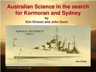
Alan Puckett Alan Puckett Used with the approval of the artist Australian Science in the search for Kormoran and Sydney byKim Kirsner and John Dunn
Summary This story is about Australian science, and the contribution that two Australian scientists made to the search for Kormoran and Sydney. Working in collaboration with the Finding Sydney Foundation(FSF) from 2001, Kim Kirsner and John Dunn identified the position of Kormoran down to 2.7 nautical miles, in 2004. They also defined appropriate search boxes for both Kormoran and Sydney in 2005. The material was published in FSF submissions to the Commonwealth, the states, the RAN, and corporate and private donors between 2004 and 2007. Kirsner and Dunn also published a critical article on the WEB (Kirsner & Dunn, 2004). In this account Kirsner and Dunn outline the steps used to achieve these objectives. The procedure is transparent and can be applied to other search projects. The Heat Map depicted in the following images was the final step in our analysis of the location of Kormoran.
Kirsner and Dunn (2004) Heat Map based on mathematical decision model. The model integrated information from nine independent sources. Kirsner & Dunn (2004) Predicted position of Kormoran: 26° 04’ South 111° 02’ East Error = Distance between Predicted and Observed positions for Kormoran = 2.7 nautical miles 26° South FSF / Mearns (2008) Observed position of Kormoran: 26° 06’ South 111° 04’ East 111° East 26° 30’ South
Alan Puckett The Ships
Kormoran was a German raider, heavily armed for close range combat with lightly armed merchant vessels but disguised as an allied merchant ship. Kormoran left Germany on December 23rd 1940, and sank eleven merchant ships prior to her engagement with HMAS Sydney. Kormoran was steaming north along the coast of Western Australia when she sighted HMAS Sydney, and turned west toward to avoid combat.
HMAS Sydney was armed and equipped for long range combat but with little or no advantage over Kormoran at the range at which the battle unfolded. HMAS Sydney was en route from Sunda Strait to Fremantle when contact was made with Kormoran. Sydney followed and gradually closed in on Kormoran until, at a range of less than one nautical mile, Kormoran opened fire and both vessels were destroyed.
In 1991 Mike McCarthy and Kim Kirsner coordinated a workshop to determine the most likely area for Kormoran. The key speakers were oceanographers or search and rescue experts. Their analyses converged on the area supported by the Kormoran survivors, near 26° South 111° East Oceanography cannot be used to define a precise site; uncertainty in the direction and velocity of current and wind is too large. Despite the fact that the oceanographic evidence provided no support for a wreck near the Abrolhos Islands, ≈ 200 nautical miles from 26° South 111° East, the McCubbin Parliamentary Inquiry (2001) failed to reject map dowsing and oral history claims for the Abrolhos, and the RAN subsequently implemented searches in the area The following figure shows the submissions by the professionals to the1991 Oceanography Workshop
Map of the region 26° South 111° East
Steedman & McCormack (1991) Oceanographers 26° South 111° East
Hughes (1991) Search and Rescue Steedman & McCormack (1991) Oceanographers 26° South 111° East
Penrose and Klaka (1991) Oceanographers Hughes (1991) Search and Rescue Steedman & McCormack (1991) Oceanographers 26° South 111° East
True Position of Kormoran Penrose and Klaka (1991) Oceanographers Hughes (1991) Search and Rescue Steedman & McCormack (1991) Oceanographers 26° South 111° East
Alan Puckett Cognitive Science
What is Cognitive Science? Cognitive Science is concerned with memory, decision-making, neuroscience, linguistics, artificial intelligence, attention, skill acquisition and a host of related problems including human error. Working together and independently, Kim Kirsner and John Dunn have published more than 150 refereed articles and chapters in the area of Cognitive Science, and held approximately 15 grants from the Australian Research Council. Kim Kirsner is an elected Fellow of the Australian Academy of Social Science.
Why wreck-hunting? Wreck-hunting is complicated. Navigation records usually provide the best source of information. In the case of Kormoran however the critical information survived the battle and a week at sea in the heads of the crew - the domain experts - and memory and forgetting were critical. In other cases oceanography might be more important, and even oral history might be relevant. Because most of the information in the archives compiled in 1941 depended on memory, Kirsner and Dunn’s expertise was appropriate. Henceforth we will refer to this material as the Kormoran Database. Where the Kormoran Database is concerned, Kirsner and Dunn are domain experts. The material from the diaries including that of Detmers was less reliable than the Kormoran Database because it was constructed months or even years after the battle. Detmers for example produced no fewer than five different positions across the RAN interrogations and diary.
The 1941 interviews and interrogations constituted the primary source. Why? First, they were reported in November and December 1941, months or possibly years prior to the preparation of the diaries and coded dictionaries. Second, as survival was critical following disembarkation from Kormoran, it may be assumed that critical information was distributed among the five lifeboat crews, and not the ‘property’ of Detmers alone Third, unless the reports associated with Detmers’ coded dictionary involve different dot patterns with the same information – and there is no suggestion that this is the case - it may be assumed that their reliability reflects only the dot copying skills of Detmers or Detmers’ secretary
What is in the Kormoran Database? • The Database included the following reports based on interrogations with survivors conducted between November 26th and December 10th 1941 • Eighteen reports referred to 26° S 111° E • Ten reports referred to either 26° S or 111° E • Six reports referred to distances from land, 60, 120 and 150 nm • Two reports stated that one lifeboat sailed ≈ 150 nm NE from Kormoran to the coast • One report stated that the battle occurred 160 nm SW of NW Cape • Four reports referred to 130 nm SW of Shark Bay • Fourteen reports referred to 26°34’, 26° 32’, 26° 31’ or 26° 30’ S 111° E. • Additional reports involve outliers and singletons
Chaos The eyewitness accounts in the Australian Archives include hundreds of descriptions of Kormoran, her voyage and the battle, Seventy of these reports include information about the location of the battle The reports referred to a vast area, from the latitude of Carnarvon in the North, to Fremantle in the South, and from 60 nm to 300 nm from the coast. How reliable are they?.
Geographical description of the Kormoran Database? The chart hints at both the spread and the concentration of the reports from the Database. The reports tend to concentrate in the vicinity of 26° South 111° East, particularly if consideration is restricted to crew who were ‘in a position to know’ However the reports ranged from the latitude of Carnarvon to the latitude of Fremantle, and from 60 to 300 nm offshore 26S 108E 26° South 26S 11E 120 nm SW of Freo 100 nm W of Freo 20 nm SW of Freo 125 nm SW of Freo 130 nm W of Perth 111° East
Zipf's Law Do the reports reflect one carefully rehearsed ‘story’, as many critics claimed, or do they reflect ignorance, as if no-one had any idea at all, or do they reflect expert knowledge, about location, accompanied by random error? Zipf's law states that given some corpus of natural language utterances (or memory reports), the frequency of any word is inversely proportional to its rank in the frequency table. The most frequent word will occur approximately twice as often as the second most frequent word, which occurs twice as often as the fourth most frequent word, etc. The same relationship occurs in many other rankings, including memory reports. In the memory case, it is assumed that the spread of the reports involves random error
Concentration of reports involving 26°South 111° East [From Kirsner, Norman & Dunn, 2003]
The frequency distribution is consistent with the assumption that the Kormoran database consists of random errors around a single position [From Kirsner, Norman & Dunn, 2003, Finding Sydney Foundation, 2005]
Cognitive Science: How reliable is the Kormoran Database? George Kingsley Zipf ‘Lecturer’ at Harvard University (1902 – 1950)
Zipf’s Law Zipf's law states that given some corpus of natural language utterances (or memory reports), the frequency of any word is inversely proportional to its rank in the frequency table. Thus the most frequent word will occur approximately twice as often as the second most frequent word, which occurs twice as often as the fourth most frequent word, etc. The same relationship occurs in many other rankings, unrelated to language, such as the population ranks of cities in various countries, corporation sizes, income rankings, and memory reports - given a single source of information. In the memory case it is assumed that the spread or reports involves random error.
Use of Zipf’s Law to assess reliability? Blue triangles are reports from Kormoran survivors Log Frequency One frequent report - ‘26° S 111° E’ Many infrequent reports, like ‘120 nm SW of Fremantle’ Log-Log coordinates Log Rank
Red triangles are reports from The “War of the ghosts’, a memory study by Bartlett (1932) Log Frequency Grey circles are from simulation based on Kormoran survivors’ reports The data conform to Zipf's law to the extent that the plot is linear in Log-Log coordinates Log Rank
Comment The data conform to Zipf's law to the extent that the plot is linear in Log-Log coordinates. The function relating Log Frequency and Log Rank is linear, and the results are, therefore, consistent with the assumption that the survivors were telling the truth Further support for this interpretation came from the fact that Bunjes, an anti-Nazi, provided three different types of information that produced approximately the same solution. More evidence, if required, came from the extra-ordinary number of survivors who pointed to 26° South 111° East. Many of these crew were ‘in a position to know’. The analysis does not address questions about the individual reports. It demonstrates that the set of reports is reliable as a ‘system’ The following figure shows how we used and interpreted Zipf’s argument
Alan Puckett Cognitive Science: Selection of Source Arguments
Comment The following analysis of source selection is a summary. The detailed arguments will be published elsewhere. Integration produced a ‘heat map’, where probability follows ‘heat’, and the central position was 26° 04’ South 111° 02’ East, just 2.7 nautical miles from the position of wreck of Kormoran. The material was provided to the FSF in 2004. The FSF reviewed, adopted and published our prediction for Kormoran in 2005 and 2007. The material was used in presentations to the Commonwealth, the States, the RAN and corporate and private donors. Further collaboration involving the authors and Director Bob King produced the search boxes for Kormoran and Sydney. The material was also provided to and discussed with Mearns, by the authors in 2004, and by the FSF, in 2005.
Discard outliers 26S 108E 26S 11E 120 nm SW of Freo 100 nm W of Freo 20 nm SW of Freo 125 nm SW of Freo 130 nm W of Perth
Accept reports referring to 26° South 111° East. Discard reports referring to only one of these values
Accept reports that one life-boat sailed ≈ 150 nm NE from Kormoran The calculated position was included in the analysis
Accept signal (from Kormoran) referring to ≈ 26° S 111° 15 E Longitude was included in the analysis, and alternative latitudes were tested to determine the best fit with the balance of the sources.
Three reports involved distance from land. Accept reports that battle occurred 120 nm from land. Discard reports that battle occurred 60 nm or 150 nm from land
Accept report that battle occurred “160 nm SW of NW Cape” as 160 nm SW of Cape Cuvier
Accept reports from Detmers referring to 26°34’, 26° 32’S, 26° 31’ and 26° 30’ S and 111° E;
Accept Detmers report that Kormoran would (have been) off Shark Bay four hours after contact with HMAS Sydney
Accept reports that battle occurred “130 nm South-West of Shark Bay”
Include Circle of Equal Distance for two life-rafts calculated by Dunn and Kirsner (2001) The analysis was originally implemented to test the navigation claims made by Whittaker (that action took place off the Abrolhos Islands. The analysis was mathematical and involved no assumptions about wind or current. Given equal velocity for 84 – 107 hours by two life-rafts, what is the range of positions from which they could have originated? The arc passes within 2 nm of the wreck of Kormoran
Summary of reports accepted for analysis Integration of these reports involved a mathematical decision model that gave equal weighting to all of the sources An alternative analysis involving weighting of the individual sources was not implemented.
Alan Puckett Cognitive Science: Integration based on Human Judgement (Kirsner & Dunn, 1998)
Kirsner & Dunn (1998): Submission to McCubbin Parliamentary Inquiry Kirsner and Dunn (1998) Position given as, “Kormoran sank a few miles to the north of “26 °15’ South 111° 00’ East.
FSF / Mearns (2008) Observed position of Kormoran given as 26° 06’ South 111° 04’ East Kirsner and Dunn (1998) Position given as, “Kormoran sank a few miles to the north of “26 °15’ South 111° 00’ East. Error ≤ 11 nm
FSF / Mearns (2008) Observed position of Kormoran given as 26° 06’ South 111° 04’ East Kirsner & Dunn (1998) Error = Distance between Predicted and Observed ≤ 11 nm Kirsner and Dunn (1998) Predicted Position given as, “Kormoran sank a few miles to the north of “26 °15’ South 111° 00’ East.