Download
1 / 1
10 likes | 135 Views
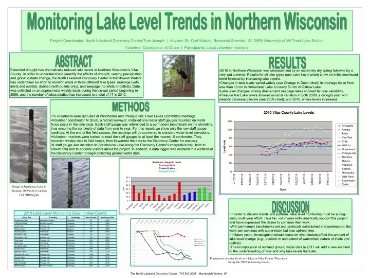
Project Coordinator: North Lakeland Discovery Center/Tom Joseph | Advisor: Dr. Carl Watras, Research Scientist, WI DNR/ University of WI Trout Lake Station Volunteer Coordinator: Al Drum | Participants: Local volunteer monitors. Monitoring Lake Level Trends in Northern Wisconsin.

E N D
Project Coordinator: North Lakeland Discovery Center/Tom Joseph | Advisor: Dr. Carl Watras, Research Scientist, WI DNR/ University of WI Trout Lake Station Volunteer Coordinator: Al Drum | Participants: Local volunteer monitors Monitoring Lake Level Trends in Northern Wisconsin Extended drought has dramatically reduced lake levels in Northern Wisconsin’s Vilas County. In order to understand and quantify the effects of drought, varying precipitation and global climate change, the North Lakeland Discovery Center in Manitowish Waters has undertaken an effort to monitor levels in three different lake types: drainage (with inlets and outlets), drained (with outlets only), and seepage (no inlets or outlets). Data was collected on an approximate weekly basis during the ice-out period beginning in 2008, and the number of lakes studied has increased to a total of 17 in 2010. ABSTRACT • 15 volunteers were recruited at Winchester and Presque Isle Town Lakes Committee meetings. • Volunteer coordinator Al Drum, a retired surveyor, installed one meter staff gauges mounted on metal fence posts in the lake beds. Each staff gauge was referenced to a permanent benchmark on the shoreline, thus ensuring the continuity of data from year to year. For this report, we show only the raw staff gauge readings. At the end of the field season, the readings will be converted to standard water level elevations. • Volunteer monitors were trained to read the staff gauges to at least the nearest .5 centimeter. They recorded weekly data in field books, then forwarded the data to the Discovery Center for analysis. • A staff gauge was installed on Statehouse Lake along the Discovery Center’s interpretive trail, both to collect data and to educate visitors about the project. In addition, a data logger was installed in a wetland at the Discovery Center to begin collecting ground water data. METHODS • 2010 in Northern Wisconsin was characterized by an extremely dry spring followed by a very wet summer. Results for all lake types (see Lake Level chart) show an initial downward trend followed by increasing lake depths. • Changes in lake levels varied widely (see Change in Depth chart) in drainage lakes from less than 10 cm in Horsehead Lake to nearly 50 cm in Oxbow Lake. • Lake level changes among drained and seepage lakes showed far less variability. • Presque Isle Lake levels showed minimal variation in both 2009, a drought year with steadily decreasing levels (see 2009 chart), and 2010, where levels increased. RESULTS • In order to discern trends and patterns, lake level monitoring must be a long-term, multi-year effort. Thus far, volunteers enthusiastically support the project and have expressed the desire to continue their work. • With permanent benchmarks set and protocols established and understood, the work can continue with supervision but less upfront time. • In future years, investigation should focus on what factors affect the amount of lake level change (e.g., position in and extent of watershed, nature of inlets and outlets). • The incorporation of wetland ground water data in 2011 will add a new element to the understanding of how and why lake levels fluctuate. DISCUSSION Gauge at Statehouse Lake in Summer 2009 (above) and in Fall 2010 (right) Fluctuation of water levels in 4 lakes in Vilas County Wisconsin during the 2009 monitoring season The North Lakeland Discovery Center 715.543.2085 Manitowish Waters, WI