Download
1 / 45
450 likes | 590 Views
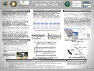
This report outlines the calibration process undertaken for the Upper San Joaquin River model, using high water mark and flow data from 2006 and 2011. Key objectives include adjusting model performance based on available data, identifying issues such as subsidence and flow measurement errors, and providing recommendations for improved accuracy. The analysis highlights significant uncertainties in discharge rates and system operations, emphasizing the need for careful consideration of model parameters and data sources. Effective management of river flows and adjustments to bi-furcation operations were also explored.

E N D
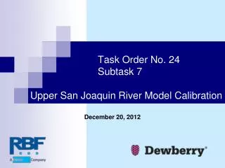
Task Order No. 24 Subtask 7Upper San Joaquin River Model Calibration December 20, 2012
Agenda • Objective • Available Data • Issues and Uncertainty • Approach – Review of 2006 Calibration Process • Results • Recommendations
Objective The objective of the calibration process is to use the high water mark and flow data from 2006 and 2011 to adjust and/or confirm the in-channel performance of a combined model built out of the approved TO 24 Subtask 6 Upper San Joaquin River models.
Available Data 2006 & 2011 surveyed high water marks 2006 & 2011 surveyed ground points 2008 LiDAR Reported gage flows and stages CVHS model routing of 2006 flows Model results based on 2008 LiDAR
Issues and Uncertainty Subsidence! Discharge rates High water marks System changes & operation Model parameters
Subsidence! • Quantified Rates of up to One Foot per Year • Subsidence could cause vertical offsets of high water marks • Non-uniform subsidence could cause changes in slope and, therefore, changes in conveyance
Comparison of 2006 Survey Data to 2008 LiDAR Indicated this Possibility
Greatest Subsidence from 2008 to 2011 on Chowchilla Canal near Ash Slough
Eastside Bypass and Chowchilla Canal Top-of-Levee 2006-2008-2011
Discharge Rates • Flow measurement & rating curve errors • Reported gage flows contain unrealistic abrupt changes • Uncertainty in transmission losses & routing from gage locations to model • System operations
Ash and Berenda Sloughs Flow split due to weir configuration • 2006: • Buchanan @5,850 cfs • Upstream ASH: 4,180 cfs • Upstream BER: 1,670 cfs • At SPFC from CVHS • Downstream ASH: 3,330 cfs • Downstream BER: 1,650 cfs • Total: 4,980 cfs (15% peak reduction) • Actual flow in 2006 and 2011 is unknown
High Water Marks Observation & staking errors Surveying errors Control point issues Timing – observations may not recorded actually peak conditions
System Changes & Operations • Changes in bank vegetation • Washout of low-water crossing • ASH-180 • Bifurcations • Chowchilla Bypass • Mariposa Bypass
Bifurcation Operations • Manually controlled gates are used at: • Chowchilla Bypass • Eastside Bypass below Mariposa Bypass • Rules adjusted for the calibration events for consistency with reported flows. This is significant for 2011 Mariposa Bypass
Model Parameters We need to consider all of the uncertainties in the source data in the process of setting model parameters so that the model results are appropriate and reasonable, but may not match the source data. Bridge modeling approach Inline weir coefficients n-values
Approach • For 2006 and 2011: • Obtain, develop and apply appropriate inflow hydrographs • Determine appropriate operating conditions at bifurcations • Compare base model results to high water marks and reported gage flows • Make appropriate model parameter adjustments • Recommend appropriate adjustments
2006 Inflow Hydrographs • CVHS flows for upstream limit of: • San Joaquin and Fresno Rivers • Ash Berenda Sloughs • Owens and Bear Creeks • Gage flows for: • James Bypass • Merced River
2006 Inflow Hydrographs (Cont’d) Lateral inflow added to Mendota Pool to compensate for spilled flows from James Bypass so as to match gaged flows below Mendota Dam Minor inflows added to the San Joaquin River below Washington Road and to Fresno Slough for modeling purposes
Chowchilla Bypass Reported and Computed Flows Thin red line is flow from the model results.
Chowchilla Canal n=0.055 n=0.035 Questionable HWMs Unreasonable n-value adjustment Subsidence & survey issues
SJR-008 Added, Reported and Computed Flows Added Reported Computed
SJR-008 0.02 n-value adjustment Subsidence
Eastside Bypass above Washington Rd Momentum bridge modeling approach turned off
Fresno River Flow uncertainty HWM issue Subsidence No adjustments made
Ash Slough Flow uncertainty Subsidence n revised 0.045 to 0.055 Structures modified
Berenda Slough Flow uncertainty Subsidence Survey No revisions made
Eastside Bypass below Washington Rd Upstream from Mariposa Bypass Downstream from Mariposa Bypass
Eastside Bypass and Deep Slough No revisions made Flows may have been higher 2,000 cfs <1 foot
Bear Creek n-value adjusted from 0.035 to 0.03
SJR-022 and Mariposa Bypass Mariposa Bypass n-value adjusted from 0.035 to 0.03
San Joaquin River above Merced River If reported flows are correct, modeled flows are too low and adjusted n-values are too high.
2011 Calibration Process Similar approach to 2006, but no CVHS hydrographs Significant issues with some reported gage flow hydrographs Subsidence evident without survey uncertainty
2011 Chowchilla Bypass Flow Uncertainty Reported stage does not support rapid change in discharge
Eastside Bypass above Washington Rd Subsidence! Momentum method
Recommendations Address subsidence No changes in n-values are recommended based on results of 2006 and 2011 given the uncertainty in flow rates Do not use the low flow momentum bridge modeling approach where it produces unrealistic headlosses Survey inline structures where LiDAR was used and the results are questionable