Download

1 / 43
440 likes | 568 Views
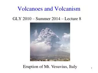
Volcanoes and global climate. volcanoes. * How are they created? * Where are they located, and why? * What does the inside of a volcano look like? * How can we predict them? * What happened at Mt St Helens?. Why do they happen?.

E N D
* How are they created?* Where are they located, and why?* What does the inside of a volcano look like?* How can we predict them?* What happened at Mt St Helens?
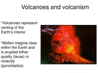
Why do they happen? A destructive plate boundary (Convergent Boundary) is found where a continental plate meets an oceanic plate. The oceanic plate descends under the continental plate because it is denser. As the plate descends it starts to melt due to the friction caused by the movement between the plates. This melted plate is now hot, liquid rock (magma). The magma rises through the gaps in the continental plate. If it reaches the surface, the liquid rock forms a volcano.
Why do they happen? At a constructive plate boundary (Divergent boundary), two plates move apart. As the two plates move apart, magma rises up to fill the gap. This causes volcanoes. However, since the magma can escape easily at the surface, the volcano does not erupt with much force.
Label this cross section of a volcano • Volcanic bombs, ash, lava, gases • Magma chamber • Parasitic cone • Crater • Main vent
Magma chamber Cross section of a volcano Volcanic bombs, ash and gases Crater Parasitic cone Main vent
Volcano shapes Why do volcanoes have different shapes?
Look at their location on the map below. Why is this an unusual place for them to be located? Hawaii The Hawaiian islands are a chain of volcanoes in the Pacific Ocean.
Hot spot volcanoes In the animation above, why are the volcanoes to the left of the ‘hot spot’ extinct?
Active, extinct, dormant • What do you think these three terms mean? Write a description of them
Prediction • How do you think volcanoes can be predicted? Take two minutes to consider how it’s done... • There are three ways: • Measuring seismic activity • Measuring poison gasses • Satellite imagery • Let’s look at these in turn
Prediction: Seismic activity You should remember from when we studied earthquakes that when the ground starts to shake, seismic waves pass through the ground from the focus. Volcanoes are often accompanied by seismic disruption due to the rubbing of tectonic plates together. If seismic activity increases near a volcano (if the ground starts to shake more), then this is a sign that an eruption is likely.
Prediction: poison gases As magma nears the surface and its pressure decreases, gases escape. This process is much like what happens when you open a bottle of soda and carbon dioxide escapes. Sulphur dioxide is one of the main components of volcanic gases, and increasing amounts of it herald the arrival of increasing amounts of magma near the surface.
Prediction: satellite imagery Satellites can pick up subtle changes in the temperature of clouds near a volcano, as well as subtle changes in the ground temperature. Increasing heat is a likely indicator of an eruption. If a volcano becomes deformed it is likely that changes inside the mountain are making it so. Mount St Helens bulged before it erupted in May 1980.
Pyroclastic flow Pyroclastic flow is the fast-moving current of hot gas and rock which travel away from the volcano at speeds as great as 450 mph. The gas can reach temperatures of 1000c The flow normally hugs the ground and travels downhill, destroying much in its path.
Mt St Helens eruption (May 1980) Mt St Helens is located on the ‘Ring of Fire’. Internet Links http://volcano.und.nodak.edu/vwdocs/msh/msh.html
North American plate Juan de Fuca plate Mt St Helens – causes of the eruption Mt St Helens is located on a destructive plate boundary where a continental plate (North American) meets an oceanic plate (Juan de Fuca). Which plate is denser? Describe what happens when the oceanic plate descends under the continental plate.
The detail • Mount St Helens is in Washington State, USA. • The volcano forms part of the Ring of Fire • The volcano had lay dormant for 123 years • The eruption was preceded by two months of seismic activity and steam venting • On March 18th, an earthquake of magnitude 4.2 was experienced • There were 8 earthquakes per day in the week building up to the eruption
The detail (2) • The side of the mountain bulged by 120m in the build-up to the eruption • It erupted on May 18th 1980 at 8:32 am. • The eruption was so powerful that the mountain's summit was blown off, reducing it from 2,950 m to 2,550 m • The eruption column rose 24,000m into the sky and fell on 11 US states • Huge mudslides were created by the blast • Fifty-seven people were killed; 250 homes, 47 bridges, 15 miles of railways, and 185 miles of motorway were destroyed • The damage cost over one billion dollars
This shows the landslide (green) and the directed blast (red) that occurred during the first few minutes of the eruption of Mount St. Helens in 1980.
Mt St Helens – consequences of the eruption AFTER BEFORE
Short-term and long-term effects • Short-term • 70mm of ash fell. 7000 students have an early holiday • Mudflows blocked and diverted rivers • Railway and road bridges destroyed • Portland harbour was blocked • Hot mudflows raised the temperature of rivers and lakes to 30C • Unemployment grew tenfold immediately after the eruption
Short-term and long-term effects • Long-term • Burrowing gophers increased the fertility of the soil by mixing in the ash • Tourism increased • Deer mice, vole, chipmonk and gopher populations increased due to the lack of predators • The US Government spent $951million on disaster relief
! ! ! Emergency planning Imagine that you are part of the emergency planning team for an impending volcanic eruption. A (fake) volcano is found at grid reference 3505, with the crater located at 347052. Signs of an impending eruption have been growing. There are real concerns for the people of Ambleside. What will you do, where will you do it, and in which order is it best done?
Remember: Where? When? Why? Is there any crucial information you haven’t been told? What can you do? • Road blocks • Evacuation of people • Radio warnings • Leaflet drops • Moving animals • Dispatch search and rescue teams • Block rivers • Anything else? Prioritise the actions you will take and justify why you have done them in that order.