Download
1 / 9
100 likes | 119 Views
Learn about the vital role of CORS stations in geodetic control, their accuracy and future outlook. The NOAA CORS Network, with close to 1900 GPS/GNSS stations, supports various applications like GIS, mapping, and research. Discover the economic benefits and ongoing improvements to enhance data quality and accessibility. Join the NGS webinar in June to stay updated on the latest developments in CORS technology.

E N D
Modernizing the NOAA CORS Network Theresa Damiani, Ph.D. Chief, Spatial Reference System Division May 7, 2019 NGS Geospatial Summit
Outline What is a CORS? How many are there? What are they for? How valuable are they? How accurate are they? What is their future?
What is a CORS? • A Continuously Operating Reference Station (CORS) • Records signals of position and time from satellites in orbit • GPS (U.S. Global Positioning System) • Sometimes GNSS (Global Navigation Satellite Systems) owned by other countries • Located, monumented, and operated to provide geodetic-quality control • CORS managed by NGS are part of the NOAA CORS Network
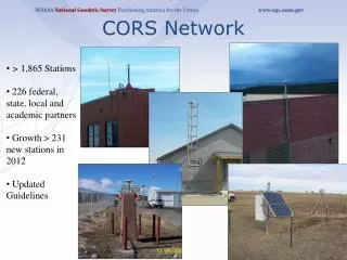
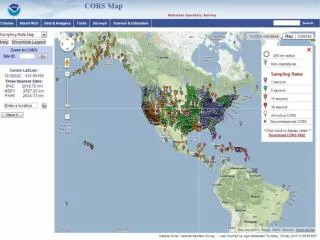
Snapshot of the NOAA CORS Network • ~1900 GPS/GNSS CORS • Run by various agencies and research groups • Largest sector of contributors is state government (DOTs and geodetic offices) • Largest single contributor is the NationalScience Foundation • Founded in 1994 Celebrating 25 years!
Uses of the NOAA CORS Network • Define and provide access to the National Spatial Reference System • CORS quality: residual RMS < 2 cm horizontal, 4 cm vertical (~3/4”, 1.6”) • Monitoring tectonic plate motion, rotation • Provide active control for GPS positioning through OPUS • Control for the surveying and mapping industry • NOAA applications: nautical chart references, tide gauge references, space weather models • Other federal applications: FEMA floodplain maps, USGS topographic maps and interior water management
Socio-Economic Value A 2008 economic benefit study valued CORS at $583 million A new NGS-estimated update to that study values CORS at $2.61 billion Despite an increase in demand, the number of CORS has been near the limit that NGS can support for 7 yrs.
New CORS Coordinates/Velocities • The NGSCORS Network has two sets of coordinates and velocities for each station- in the national and international reference frames • Multi-Year CORS Solution 2 (MYCS2) • NAD83 (2012) epoch 2010 and ITRF 2014 epoch 2010 • 1994-2017, ~ 3050 stations: All active CORS, decommissioned CORS, and International GNSS Service (IGS) stations. • Improvements over MYCS1 (completed in 2011) • ~1800 active + ~800 decommissioned CORS stations (~450 more than 2011) • 7 more years of data • Nearly 1000 more CORS have official computed coordinates and velocities • ~240 new CORS (<3 yrs old) with approximate “modeled” coordinates and velocities On BETA now Upcoming NGS Webinar in June!
NOAA CORS Network Quality AND AND OR
Modernizing the NOAA CORS Network • Provide access to the National Spatial Reference System (NSRS) • Maintain quality of: 5 mm horizontal, 10 mm vertical (0.2”, 0.4”) • That’s nearly 75% BETTER than before; all but 16 CORS will meet standard • CORS Comprehensive Plan (Fall 2020) • Automate CORS network management and metrics (quality, availability, etc.) • Increase CORS partner communications • Better models of motion, for both plate rotation and regional motion (IFVM) • Provide an RTN-alignment service (RAS) • Improvements to OPUS for selection of CORS • CORS website redesign