Download
1 / 49
680 likes | 1.25k Views
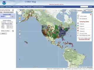
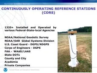
CORS Network. > 1,865 Stations 226 federal, state, local and academic partners Growth > 231 new stations in 2012 Updated Guidelines. CORS. CORS. CORS “Data Products” Page. Obtain Static Data Files for CORS Here. Provide Information about your Project. Enter your custom requests.

E N D
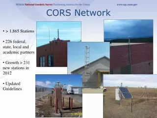
CORS Network • > 1,865 Stations • 226 federal, state, local and academic partners • Growth > 231 new stations in 2012 • Updated Guidelines
CORS “Data Products” Page Obtain Static Data Files for CORS Here
CDOT CORS/OPUS Team • To incorporate CORS and OPUS into the CDOT Survey Manual • Presented to SAC on Feb 15, 2012 • Proposed Addendum • Recommendations
CDOT CORS/OPUS Team Addendum
Online Positioning User Service (OPUS) • Users submit GPS data to NGS • Data is processed using NGS computers and software • Resulting precise positions e-mailed back to the user • Solutions up to 1-2 cms in accuracy provided by email • OPUS Rapid Static - 15 minutes of data vs. 2-4 hours http://geodesy.noaa.gov/OPUS/
yourGPS data IGS & NGS base stations & site information filesIGS antenna calibrations & satellite orbits & reference frames UNAVCO teqc converterPAGES baseline processor var. geophysical models NGS geodetic toolkit geodetic standard data Online Positioning User Service OPUSgeodesy.noaa.gov/OPUS/ JGE 2011v1 yoursolution options: projects & publishing mark description
OPUS • OPUS – S (2 hrs) • OPUS – RS (15 minutes) • OPUS – DB (Publish) • OPUS – Projects (Network)
OPUS Submission Webpage Your email address Location of your data file Your antenna type Antenna height Customize your solution - details on next slide
New Look And Feel. The Options button “accordions” to a streamlined set of menus and entry fields. No more jumping to a new page.
OPTIONS extended solution in/ Exclude CORS SPC zone geoid model project profile publish OPUS-RS or OPUS-Static (15 min-2 hr) (2-48 hr)
Online Positioning User Service (OPUS) • >15 min of L1/L2 GPS data >>> geodesy.noaa.gov/OPUS/ • Processed automatically on NGS computers, tied to CORS • Solution via email - in minutes • Fast, easy, consistent access to NSRS
Static: OPUS determines your position with a differential GPS static solution, using hours of data. This process is repeated 4x from other CORS. solution 2 CORS solution #1 solution 3 solution 4 solution 5
solution 2 = h your position:averaged from the “best” 3 of 5 CORS solutions f CORS solution #1 l = = solution 3 your peak-to-peaks:scaled from the spread of the 3 CORS solutions solution 5 = = solution 4
Rapid-static: OPUS first creates an atmospheric delay model from surrounding CORS data. Your position is then quickly determined by differential GPS static solution.
ARP MARK • The height is measured vertically (NOT the slant height) from the mark to the ARP of the antenna. • The height is measured in meters. • The ARP is almost always the center of the bottom-most, permanently attached, surface of the antenna. • See GPS Antenna Calibration for photo’s and diagrams that show where the ARP is on most antennas: • http://geodesy.noaa.gov/ANTCAL/ • If the default height of 0.0000 is entered, OPUS will return the position of the ARP. How is the Antenna Height Measured?
phase ctr. Why Do I Need the Antenna Type? The antenna phase centers are located somewhere around here. The antenna offsets are the distance between the phase centers and the ARP ARP You do not need to know these offsets. They are passed to the processing software through the antenna type The Antenna Reference Point (ARP) is almost always located in the center of the bottom surface of the antenna. Incorrect or missing antenna type big vertical errors
relative absolute NGS Antenna Calibration –Relative vs. Absolute GNSS Antenna Calibration 2 hours GPS tracking
How Does OPUS-RS Work? • OPUS-RS selects three to nine “best” CORS based upon: • Having common satellite visibility with the user data. • Having distances from the user’s site <250 km. • This is shown here graphically. The star represents the user’s site. The triangles are CORS. • No CORS farther than 250 km from the user’s site will be included. • The three CORS minimum is shown.No more than nine are used. s >250km 250km Choi, 2010, personal communication.
How Does OPUS-RS Work? In addition, user’s site must be no more than 50 km from the (convex) polygon created by the selected CORS. Again in this figure, the star represents the user’s site; the triangles are CORS. Five CORS and their resulting polygon are shown in this example. If the user’s site, the star, is more than 50 km outside this polygon, alternate CORS will be considered. If none can be found, the processing will abort. Schwarz et al., “Accuracy assessment of the National Geodetic Survey's OPUS-RS utility”, 2009, GPS Solutions, 13(2), 119-132.
How Good Can I Do With OPUS-S? More generally, Eckl et al. (NGS) preformed a similar but more extensive test using the same software but outside OPUS. Eckl et al., 2001, “Accuracy of GPS-derived relative positions as a function of interstation distance and observing-session duration”, J. of Geod. 75, 633-640). Their results provide a good “rule of thumb” for accuracy versus session duration when using OPUS-S and in many other applications.
5,000++ OPUS-Published Solutions April 2012
Why OPUS-DB • A new easier way to capture data and have it in an NGS database • Help populate Ellipsoidal Heights on Bench Marks, help with Geoid models and future vertical datums • To the extent (?) they've bluebooked in the past, they can continue into the future more easily. • If they are running RTK, this would help determine base station position and document where it was used, assuming they left a permanent mark. • Changeover to new datums; either we maintain the data or user does for highest accuracy, but models will be available for bringing old coordinates forward.
Marks Published. OPUS is showing steady growth in registered users and published marks.
NGS Data Sheets Traditional blue booking New OPUS-DB
OPUS DB Requirements Field Procedures • GPS data file ≥ 4 hour duration • quality mark setting • experienced observer • fixed height tripod recommended • brace tripod legs with sandbags or chain • verify antenna height and plumb
OPUS DB Requirements High-Quality OPUS Solution • ≥ 70% observations used • ≥ 70% ambiguities fixed • ≤ 3 cm RMS • ≤ 4 cm peak-to-peaks, lat. & lon. • ≤ 8 cm peak-to-peak, el. hgt. • properly identify antenna type • precise or rapid orbits (avail. next day)
OPUS DB Requirements Mark Attributes • photos of mark & equipment • details (name, type, stability, etc.) • description to aid mark recovery • preview mark description form& help file
Issues to Consider • Site • instability, multi-path • mark ID (search database, check stamping) • Weather • wild, local troposphere issues? • space weather: ionospheric issues? • “Truth” (orbits, CORS, etc.) • Rapid (next-day) orbits required for publishing
39 Interface The user is taken to a new page where they designate the mark associated with their data as “new” or “recovered”.
Interface - “Existing” mark designation After making that selection, the user is offered the appropriate form for entering the meta-data.
Review If the meta-data is complete, the quality control restrictions are met and the user gives the “OK”, the submission is entered into the data base after review by NGS.
43 OPUS-DB Solutions http://geodesy.noaa.gov/OPUS/view.jsp
45 Interface This is part of a published data sheet. Note the “See Also” highlight. Note the “See Also” highlight. This provides access to other data base and IDB entries for this mark.
OPUS – Datasheet Publishing • Publishing Criteria: • NGS-calibrated GPS antenna • > 4 hour data span • > 70% observations used • > 70% fixed ambiguities • < 0.04m H peak-to-peak • < 0.08m V peak-to-peak • Uses: • GPS on BMs • PLSS / GCDB • Data archive • Data sharing
Orthometric Height Comparison 871.746 m Published NAVD88 871.800 m OPUS GEOID09 0.054 m (0.18 ft) Difference
OPUS-projects: • first, run OPUS to harvest all project data • OPUS automatically forms sessions from simultaneously observed marks, allowing multi-baseline processing and adjustment of multiple sessions.
GNSS • What’s happening now? • Schenewerk is extending the PAGES suite to handle GLONASS and other GNSS. • GLONASS PAGES will be able to process integer-fixed or float GPS and float GLONASS separately or together. • The software is literally an extension of PAGES which has been proven in a variety of operational tasks.