CHARMS: National-Scale Hydrological Modeling Implementation
This study showcases the implementation of a catchment-based hydrological and routing model system known as CHARMS on a national scale. CHARMS consists of a modified land surface model based on the Community Land Model and a river routing model that accounts for water transport. Preliminary results demonstrate the model's ability to estimate river discharge, depth, and inundation accurately. Further work is needed to improve the model's performance, especially in accounting for lakes, reservoirs, and anthropogenic effects. The study upscales river networks from the NHDPlus dataset and involves 2959 catchments with an average area of 2773 km2. River routing in CHARMS considers surface and subsurface runoff contributions from hillslopes and upstream reaches. Meteorological data and parameters are derived from various datasets for accurate modeling. The study shows promising results in capturing seasonal variability but highlights the need for continuous enhancements for national-scale simulations.

CHARMS: National-Scale Hydrological Modeling Implementation
E N D
Presentation Transcript
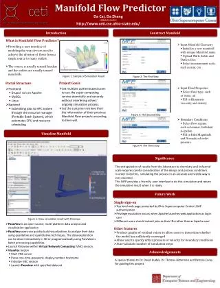
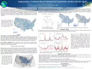
Implementing a Catchment-Based, National-Scale Land Surface and River Routing Model Zhao Liu1 (zliu2@uci.edu), James S. Famiglietti1, 2, HyungJunKim3, 2 1. Department of Earth System Science, University of California, Irvine, CA, 92697 2. UC Center for Hydrologic Modeling, University of California, Irvine, CA, 92697 3. Institute of Industrial Science, University of Tokyo, Tokyo, Japan • Methods • Estimating water depth and inundation extent: The river geometry is needed for both separating the main channel and floodplain and estimating the corresponding river depth and width (Fig. 3). With the USGS field measurements of gauge height and discharge, the empirical relationship are established as below. And the main channel and the floodplain are separated following the power law method. The empirical relationship is constant for the whole Mississippi basin, which will be replaced by different relationships for each sub water resources region respectively in the future. The derived bankfull depth andbankfull width are shown in Fig.4. • Preliminary Results • The streamflow observations are from USGS surface water for the nation. The simulation starts from 1980-01-01. The daily simulated discharge for the Mississippi river basin from upstream to downstream from year 2006 to 2009 are shown in Fig. 5. Introduction The main motivation of this study is to characterize how accurately we can estimate river discharge, river depth and inundation under a catchment-based hydrological and routing modeling system (CHARMS)[1] framework. Here we present a national-scale implementation of CHARMS that includes an explicit representation of the river network upscaled from the NHDPlusdataset (Fig.1). There are two main components in CHARMS: a land surface model based on the Community Land Model (CLM) 3.5[2], which is modified for implementation on a catchment template; and a river routing model that considers the water transport of each river reach in each catchment. Figure1: Explicit representation of river networks for the national- scale CHARMS modeling template. It includes 2959 catchment cross the nation and there is one main river reach in each catchment. Different colors represent the strahler stream order for each river reach. Figure 3: Schematic plots of river cross section profile in CHARMS Figure 4: The derived bankfull depth (left) and bankfull width (rigut) of the rivers in the Mississippi Basin Fig.5 shows the comparison between the simulation and the observations. These are preliminary results without any calibration. The simulated discharge compare fairly well with the observations. CHARMS is able to capture both the seasonal and the daily variability at upstream. The accuracy of the simulated discharge decrease towards the downstream. Inappropriate constant empirical relationship describing the river cross-section profile , poor runoff generation from from CLM3.5, and no consideration of lakes and reservoirs/anthropogenic effect/human regulation can all contribute to this discrepancy. More work still need to be done. • Methods • Upscaled River network from NHDPlus dataset: • The catchment-based model template is built upon NHDPlus. HUC8 (Hydrologic Unit Code) is chosen as the average catchment. In each HUC8 unit, all the small basins are merged together, and there is one main river stream extracted using Strahler Stream Order (SC), and the main stream is then further divided into sub reaches. After the upscaling, there are in total 2959 catchments, with an average area of 2773 km2, and 198633 sub reaches, with an average length of 1.67 km (Fig1). • River routing in CHARMS: The total inflow into a reach accounts for the contribution from hillslope by both the surface runoff and sub-surface runoff, and any flow from upstream reaches including both main channel and floodplain. • Both the surface runoff and subsurface runoff come from the modified catchment-based CLM3.5. The meteorological forcing data is from NLDAS 1/8 degree 3 hourly dataset. And the 0.5 degree surface parameters including soil properties, vegetation types etc. are based on the grid-based CLM3.5. All the grided forcing was converted to the catchment using the area weighted sum (Fig.2). Instead of running the model with a lat-long 2D grid unit, CHARMS assign each catchment a HydroID. And the model is run on this 1D catchment template, starting from the most upstream to the downstream end. Figure 5: Simulate discharge compared with USGS gauge observations. The gauge stations are labeled as red dots on Fig. 2. • Discussion and Future Work • With an explicit representation of river network, CHARMS is capable of capturing the seasonal variability of streamflow, although more work still are still needed to be done for the simulation in term of amplitude for the national scale simulation. • Different empirical relationships between channel dimensions and drainage area will be derived for each water resources region for the national scale implementation. • CLM4.0 will replace CLM3.5 to provide a better generation of runoff for CHARMS. • Parameter optimization are also needed for further improvement of this national scale implementation. • Since the SWOT mission will provide both the water height and inundation extent for rivers globally, the results in this study have implications for assimilation of surface water altimetry and for implementation of the approach at both the national and continental scale. • n Figure 2: Interpolation scheme of converting grid-based CLM3.5 to catchment-based CLM 3.5. It shows the 1 degree grid covering the country and the intersected Mississippi basin with 1/8 degree grid. The blue line is the main river reach of the Mississippi Basin, and the red dots are the USGS gauge stations. Acknowledgments This work was supported by grants from the NASA Earth and Space Science Graduate Fellowship program. References [1] Goteti, G., J. S. Famiglietti, and K. Asante (2008), A Catchment-Based Hydrologic and Routing Modeling System with explicit river channels, J. Geophys. Res., 113(D14), D14116. [2] Community Land Model 3.5: http://www.cgd.ucar.edu/tss/clm/distribution/clm3.5 [3]Bjerklie, D. M., S. L. Dingman, and C. H. Bolster (2005), Comparison of constitutive flow resistance equations based on the Manning and Chezy equations applied to natural rivers, Water Resour. Res., 41(11), W11502.