Download

1 / 27
270 likes | 288 Views
Learn about the Earth's crust, continents, plate tectonics, Alfred Wegener's theories, support for continental drift, plate movements, types of plate boundaries, volcanoes, earthquakes, and seismic activity.

E N D
The Crust • This is where we live! • The Earth’s crust is made of: • Continental Crust • thick (10-70km)- buoyant (less dense than oceanic crust) - mostly old Oceanic Crust - thin (~7 km)- dense (sinks under continental crust)- young
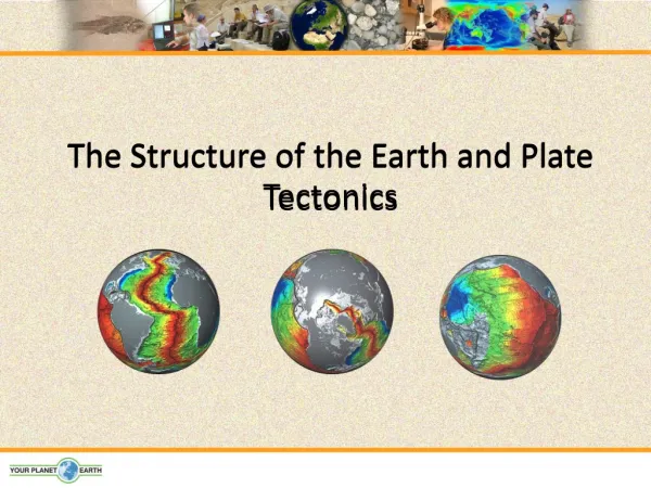
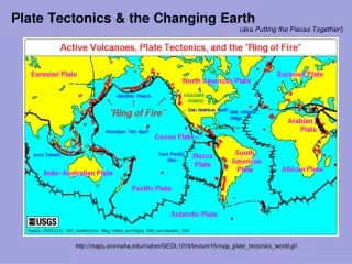
Plate Tectonics • The Earth’s crust is divided into 12 major plates which are moved in various directions. • This plate motion causes them to collide, pull apart, or scrape against each other. • Each type of interaction causes a characteristic set of Earth structures or “tectonic” features. • The word, tectonic, refers to the deformation of the crust as a consequence of plate interaction.
Alfred L. Wegener • Geologist Alfred Wegener noticed similar rocks & fossil remains were found on continents which seemed to fit together • He called this “super” continent called Pangaea • In 1912 Wegener published the first version & died defending his theory
PANGAEA - the large landmass that included all of Earth’s present day continents
Support for Continental Drift 1. SHAPE of the continents Continents fit together like puzzle pieces
Support for Continental Drift 2. FOSSIL EVIDENCE SAME FOSSILS: DIFFERENT CONTINENTS Mesosaurus was incapable of swimming across a large ocean.
Support for Continental Drift 3. ROCK EVIDENCE – Mountain ranges • SAME ROCK: DIFFERENT RANGE Existing mountain ranges separated by vast oceans contain rocks of identical mineral content. • A prime example are the Appalachian Mountains in the eastern U.S and the Caledonian Mountains in the British Isles.
SAME SCARS: DIFFERENT CONTINENTS Support for Continental Drift 4. GLACIAL SCARS
5. LOCATION OF Coal Deposits Support for Continental Drift Coal deposits have been found in temperate and polar regions; however, coal is formed in tropical regions.
Plate Movement • “Plates” of lithosphere are moved around by the underlying hot mantle convection cells
Three types of plate boundary • Divergent • Convergent • Transform
Iceland: An example of continental rifting • Iceland has a divergent plate boundary running through its middle
Convergent Boundaries • There are three styles of convergent plate boundaries • Continent-continent collision • Continent-oceanic crust collision • Ocean-ocean collision
Continent-Continent Collision • Forms mountains,e.g. European Alps, Himalayas
Continent-Oceanic Crust Collision • Called SUBDUCTION
Ocean-Ocean Plate Collision • When two oceanic plates collide, one runs over the other which causes it to sink into the mantle forming a subduction zone. • The subducting plate is bent downward to form a very deep depression in the ocean floor called a trench. • The worlds deepest parts of the ocean are found along trenches. • E.g. The Mariana Trench is 11 km deep!
Transform Boundaries • Where plates slide past each other Above: View of the San Andreas transform fault
Pacific Ring of Fire Volcanism is mostly focused at plate margins
What are Hotspot Volcanoes? • Hot mantle plumes breaching the surface in the middle of a tectonic plate The Hawaiian island chain are examples of hotspot volcanoes. Photo: Tom Pfeiffer / www.volcanodiscovery.com
Where do earthquakes form? Figure showing the tectonic setting of earthquakes
What is an earthquake? • They are caused by the release of energy • They cause the ground to shake • Reasons: • Plates Moving • Faults (cracks in Earth’s surface) • Caverns collapsing • Meteor Impacts • Volcanic Eruptions
The San Andreas is a • Strike Slip (Transform) Fault • One piece of Earth slides past another
Terms used to describe an earthquake Focus: area beneath Earth’s surface where rock that was under stress begins to move or break. Epicenter: Point on surface directly above the focus. Focus vs. Epicenter
How are earthquakes detected? • Earthquakes are detected by seismographs • Seismographs record the information on a seismogram
How is the strength of the earthquake determined? • Intensity • The effect of the Earthquake on the area • Measured by the Mercalli Scale (shaking) • Magnitude • The actual energy released by the Earthquake • Measured by the Richter Scale (I-XII)