Download
1 / 1
10 likes | 132 Views
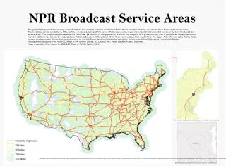
NPR Broadcast Service Areas. The goal of this project was to map out and analyze the existing network of National Public Radio member stations and model their broadcast service areas.

E N D
NPR Broadcast Service Areas The goal of this project was to map out and analyze the existing network of National Public Radio member stations and model their broadcast service areas. The models assumed all stations, AM and FM, were broadcasting at the same effective power level per model and that terrain did not severely limit the broadcast service area. The project substantiates NPR’s claim that 99 percent of the population is within the range of NPR programming, this is possible as independent non-member stations can license to broadcast any Public Radio content they deem fit for their community, which would fill in the gaps. Also NPR and other Public Radio content producers can license their programming to the XM/Sirius Satellite network servicing the Continental United States and Hawaii and Alaska. The data was obtained from the FCC, Atlas of the United States, US Census, MIT Radio Locator Project and NPR. Maps created by John Hattin for GIS-205 Class at NVCC, Spring 2009. NPR Stations along Interstate 95 through the Mid-Atlantic and New England. Nationwide NPR broadcast service area map. Most of the country is covered by the ideal 100 Mile Broadcast model. In the eastern half of the United States the more realistic 25 and 50 Mile Broadcast models adequately cover most of the land and densely populated urban areas. In the western half of the country where the population is more sparsely distributed, the 75 and 100 Mile Broadcast models cover most of the bigger cities. WETA’s Broadcast Coverage Area according to the FCC ~ 20 Mile radius