Download
1 / 1
10 likes | 163 Views
Nimbus Satellite Data Rescue Project for Sea Ice Extent: Preliminary results from September 1964, 1966, and 1969. D. Gallaher 1 , W. Meier 1 , G. Garrett Campbell 1 , John F. Moses 2 1: NSIDC, U of Colorado, Boulder, CO 2: GSFC NASA Greenbelt MD. C41E-0471 AGU 2011 nsidc.org.

E N D
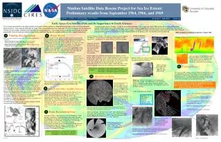
Nimbus Satellite Data Rescue Project for Sea Ice Extent: Preliminary results from September 1964, 1966, and 1969 D. Gallaher1, W. Meier1, G. Garrett Campbell1, John F. Moses2 1: NSIDC, U of Colorado, Boulder, CO 2: GSFC NASA Greenbelt MD C41E-0471 AGU 2011 nsidc.org Early Space Era Satellite Data and Its Importance to Earth Sciences It is of critical importance in the study of Earth Sciences to reliably extend our data sets farther back in time to incorporate early space missions. This presents difficulties as many of the original data sets have been lost. The time to recover this information is running out as the data, hardware and expertise are rapidly dying out. If secondary sources can be reconstructed from data processed in that era and reprocessed using modern methods, they can be valuable additions to the research community. The early Nimbus Series (Nimbus I, II, and III) are excellent examples. The images from early 1960s exploration missions of the Argon, Corona, TIROS, ESSA and COSMOS programs are resources, largely untapped by the community, that can be integrated as a resource for data continuity and as an independent source of Earth imagery. This global coverage, time-series data, covers the period from 1962-1978 and could potentially extend the Earth Science Data Record (ESDRs) at the poles by 50% from the base 1979-2009 period. HRIR Composites of maximum temperature: August 1966. Nimbus Background Prior Work 1 2 Nimbus 2 Analysis First it is necessary to adjust the scan line alignment before mapping the radiances. The pictures of lake Michigan show before and after adjustments. The Nimbus II, III, and IV IR data all have this problem. Many researchers in the 1960’s and 1970s used the early Nimbus data to examine sea ice. Predoehl (1966) attempted to calculate the Antarctic sea ice extent from Nimbus I data. Sissala et al (1972) calculated the sea ice extent for the months of July and August from Nimbus II and III AVCS and HRIR film records. The 1966 values they determined are significantly different than the 1979-2010 baseline. This is due to either an error in their methodology or that conditions in the mid 1960’s were significantly different from we’ve seen over the last 30 years. Recent studies have used 1962-63 Argon data for mosaics of Antarctica and Greenland. • Earth observations started on August 28, 1964 (with breaks between missions) • Advanced Vidicon Camera System (AVCS) to provides television images (resolution better than 3 km at nadir) • High resolution Infrared Radiometer (HRIR) to map the Earth at night (resolution 8 km at nadir) The gray wedges on each picture allow a “calibration” of the visible brightness. Alignment Correction by comparing each line to an average of 7 lines to derive a left right shift. This preserves the raw 8 km resolution. One can imagine that the HRIR data could be used for global studies of climate in the 1960’s. Here we can see variation of SST like the Gulf Stream to the left. This is beyond the scope of our current proposal. Nimbus 2 geometric remapped composite of 5 images near Greenland Nimbus 2: We are now working on calibration and “de-banding” the Nimbus 2 data. There are 4 months of Nimbus 2 and many more images so these problems should be overcome in the near future. 19.8 1964 First Satellite Image of Entire Antarctic Continent with Ice Extent 19.5 1964 Nimbus 3 image of ice edge from IDCS day 225, 1969 from scan of 70 mm film. The preliminary Antarctic sea ice extent estimate of September 1964, 19.5 million km2,from Nimbus 1 is higher than the 1979-2010 baseline. In contrast the 1966 estimates of Sissla are lower We will soon have independent 1966 results. Since we have the individual pictures available, we will go back and review the particular areas and times when we estimated a cloud free view of the ice edge. This will allow us to refine the results. 6 Devon and Baffin Islands, AVCS Image 9/16/64 1964 Nimbus I AVCS image of ice. • Data was collected globally twice daily with HRIR at night and AVCS by day. • The Nimbus High Resolution Infrared Radiometer (HRIR) is an excellent example of an early space era dataset. Its temperature and spatial resolution appears sufficient to be of use in studying Ice pack and cloud areal extent. • The Nimbus HRIR Instrument (Nimbus I, II, and III), used a lead Selenide (PbSe) detector to detect +/- 1 degree K IR Radiation in the 3.4 and 4.2 micron bands. Ground resolution of 8 km at 1100 km and a Sun-synchronous, 108 minute nodal period. • Early Earth-observing satellite data were not fully explored due to the limitations of historical programs and processing systems. • Much of the data has never been seen, as many of the tapes and films are either missing or are deteriorating. • The original engineers and researchers are now mostly in their 70s and 80s, and time is running out to contact them. • The objective is to get this data to earth science researchers in a form they can access (NetCDF, HDF). • The HRIR reprocessing is already underway (however, ESDRs cannot be built without the AVCS data) Visible imagery was collected with the Advanced Videocon Camera System, AVCS, on Nimbus I and II. NASA recorded this data as pictures on 35 mm film and we have been scanning that data which was stored at the NCDC archive. (We were to first to open the film canisters in 40 years.) By using the time stamp, orbit elements and camera specification we have constructed navigable visible digital data. There remains calibration and noise issues before we have a final product. Nimbus I Predoehl Our preliminary Nimbus I sea ice estimate is shown for September 1964 composite of many AVCS pictures. Our estimate of 19.5 x 10⁶ km2is potentially the largest Antarctic sea ice extent ever observed. In the near future we will have new estimates for Nimbus II 1966 and Nimbus III 1969. Nimbus 3: We have not made as much progress on Nimbus 3 as hoped. The HRIR processing is immanent. There is a different visible camera system on Nimbus 3: the Image Dissection Camera System. Its navigation is much like the HRIR scanner. Plot of historic sea ice extents 1979-2000 overlain with 2010 & 2011 extents along with Nimbus II & III derived extents for July and August of 1966, 1969 & 1970 from Sissala (1972) and September 1964 from Predoehl (1966) All of these raw data sets will be put into a public archive for general use available from NSIDC and GSFC DAAC: Fall 2012. Status: HRIR: N2 finalizing, N1+N3 pending. AVCS: N1 first pass done, N2: calibration being developed AVCS recovery: 1964 Nimbus 1 5900 frames digitized (35 mm) at NSIDC 1966 Nimbus 2 50000 frames 5000 completed (35 mm) 1969 Nimbus 3 20000 frames (bigger area) (70 mm) 3 Our first processed result is shown in the composite minimum brightness for September 1964 from Nimbus I AVCS visible data. By eye one can identify the sea ice around Antarctica. Because of limited data in 1964, an purely automatic technique can not do as well as a human. We hope there is sufficient data from 1966 and 1969 for an automatic method. Search for Other Satellite Sources Arctic Composite from Nimbus I There were over 250 satellites launched in the 1960’s that were capable of recording data and imagery of the polar sea ice extent. These were American and Soviet weather and reconnaissance satellites. Only about 30% of this data is current known to exist. These data will need to be recovered and processed if we are to create a continuous monthly sea ice extent for the 1960’s. Our best prospect beyond the Nimbus data is ESSA visible data from 1967 to 1972 and TIROS VIII and IX from 1967 and 1968. We will be reviewing this data in the near future. September 12-19 1964 Nimbus I composite minimum brightness. And individual pictures. Results to Date 5 Data Reconstruction 4 HRIR: Ice detection. We have hot yet been able to distinguish ice from ocean with the HRIR data. Once we have a visible estimate of the ice edge we will compare the HRIR temperature gradient at that location to determine if the ice has a unique signature. Conclusions Nimbus Spacecraft The original Nimbus High Resolution Infrared Radiometer, HRIR, data was recorded as analog waveforms which were received and displayed in analog form and stored for later processing. The original temporary analog tapes no longer exist. The later post-processed tapes still survive. These tapes had been geometrically and radiometricaly corrected and rectified. We have completed processing of the Nimbus II archive tapes. GSFC has rescued and recovered these HRIR data and made them available in the original TAP format. Data from these 1960’s satellites is often considered to be of poor quality as these were early/primitive sensors. We have found the data was of higher quality then expected but the output products were limited due to the computer processing technology of the era. This irreplaceable data has relevance to climate change and should be saved as a part of the climate data record. Special thanks ESDIS and NCDC for their efforts in archiving and recovering this data. Note: Because data could not be collected and transmitted simultaneously the Alaska receiving station collected data for only portions of the Arctic 5 HRIR composite maximum temperature for August 1966. EASEII grid. One can see the geography of Antarctica. Estimating sea ice in the Arctic in 1964 is more difficult because of less area coverage by the recoverable pictures. Preliminary review shows the Arctic ice extent might be less that the published record. Again, we will go back to review the individual pictures at the clear times. References Cherrix, G.T., Allison, L. J. The High Resolution Infrared Radiometer Experiment; Section 3, NASA GSFC, No publication Date, Accessed from Http://ntrs.nasa.gov/ Moses, J.F., Bedet, J.J. The Value of Cloud Top and Surface Temperature Observations from the 1966 Nimbus II High Resolution Infrared Radiometer Historical Data Record, 2008, AGU Fall Conference Kim, K., Jezek, K. C. and Liu, H. Orthorectified image mosaic of Antarctica from 1963 Argon satellite photography: image processing and glaciological applications, 2007, International Journal of Remote Sensing; Vol. 28 Issue 23, p5357-5373 Predoehl, M.C., Antarctic Pack Ice: Boundaries Established from Nimbus I Pictures Science 19 August 1966: 861-863. Acknowledgement: Project supported by NASA as a subtask to #NNG08HZ07C. Tap Files: 1964 Nimbus 1: ~300 TAP files ~200 orbits 1966 Nimbus 2: 2457 TAP files ~2000 orbits 1969 Nimbus 3: 1116 TAP files ~1000 orbits Structure of a raw Nimbus HRIR Image Row 8:00 AM - 12:20 PM; Halls A-C December 2011