Download
1 / 17
170 likes | 303 Views
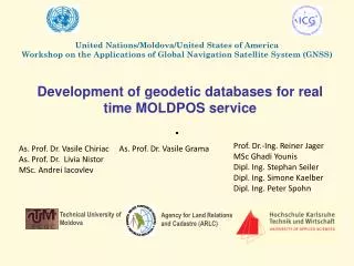
Development of geodetic databases for real time MOLDPOS service. United Nations/Moldova/United States of America Workshop on the Applications of Global Navigation Satellite System (GNSS). Prof. Dr.-Ing. Reiner Jager MSc Ghadi Younis Dipl. Ing. Stephan S eiler Dipl. Ing. Simone Kaelber

E N D
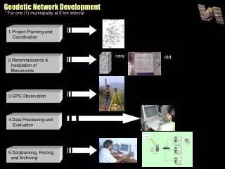
Development of geodetic databases for real time MOLDPOS service United Nations/Moldova/United States of America Workshop on the Applications of Global Navigation Satellite System (GNSS) Prof. Dr.-Ing. Reiner Jager MSc Ghadi Younis Dipl. Ing. Stephan Seiler Dipl. Ing. Simone Kaelber Dipl. Ing. Peter Spohn As. Prof. Dr. Vasile Chiriac As. Prof. Dr. Livia Nistor MSc. Andrei Iacovlev As. Prof. Dr. Vasile Grama Technical University of Moldova Agency for Land Relations and Cadastre (ARLC)
Participating institutions Memorandum of understanding between Academy of Science of Moldova and Federal Ministry of Education and research of Germany signed on 14 March 2008 Federal Ministry of Education and ResearchofGermany Academy of Science of Moldova (ASM) Bilateral Research Program to fund 1 year projects: 25 000 EURO from German site and 10 000 EURO from Moldavian site. Agency for Land Relations and Cadastre (ARLC) Technical University of Moldova (TUM) In 2008-2009 the Technical University of Moldova and in collaboration with Karlsruhe University of Applied Sciences had applied application on Development of a High Capacity Real-Time GNSS Positioning Service using new RTCM 3.1 transformation messages that can be integrated in MOLDPOS - Project launched by Agency for Land Relations and Cadastre (ARLC) funded by Norwegian Government.
Participating institutions • The Karlsruhe University of Applied Sciences has been: • Developing complete infrastructure (transformation parameter concepts, computation software and technical standards in GNSS-industry in the recent years) • The scientific member (2003 – 2007) and fully involved into the international RTCM working group on transformation messages • The second German partner has been involved as link between state and private GNSS-services, GNSS-industry and GIS and university into the developments • The Agency of Land Relation and Cadastre has experience in: • Installation, maintenance and operation of EPN GNSS reference station • GNSS network measurement and processing • The Technical University of Moldova has experience in: • Installation, maintenance and operation of EPN GNSS reference station • GNSS/RTK measurements and processing • Generation and distribution of differential corrections
Project objectives • Development of a communication architecture for providing RTCM 3.1 transformation messages • Development of a general geodetic transformation databases concept • Analysis and further scientific developments of bilateral approaches for the Height Reference Surface (HRS) modeling methods and numeric conversion procedure of ellipsoidal heights into normal heights • Study of possibilities of Digital Finite Element Height Reference Surface (DFHRS) concept Implementation in MOLDPOS database • Study of possibilities of concept and software Implementation in MOLDPOS to monitor permanently the coordinate integrity of the GNSS reference stations • Testing out of the final DFHRS and COPAG/ DFLBF databases based on the Karlsruhe state of the art of the mathematical models
Preconditions for new geodetic infrastructure development Introduction of New Reference Systems and Map Projections Vertical reference systems: Baltic Sea 1977 - EVRS2000 ITRS 97 ETRS 89 SC 42 WGS 84 Ellipsoids Krasowsky WGS84 GRS80 Map projections Gauss Kruger Gauss Kruger UTM TMM 6 zone 1: 25 000 – 1.500 000 MOLDREF99 1:500 - 1: 10 000 6 zone 1: 10 000 – 1.500 000 3 zone 1: 500 – 1:10 000
Preconditions for new geodetic infrastructure development OTACI UNGHENI CHELTUITORUL NOU PALANCA GIURGIULESTI Development of the National GPS Network GPS measurements (1999-2002) EUREF sites (5) first-order sites (72) second-order sites (418)
Preconditions for new geodetic infrastructure development Reconstruction of the National Leveling Network • Reconstruction and integration in ULEN • 1st polygon (350 km) closed in 2008 • 2nd polygon (429 km) performed 202 km in 2009 • 3rd polygon (116 km) performed 30km in 2008 • 4th polygon (267 km) to be performed in 2010-2011 4699 8712 1652 356 1 38 231 96 244 3 2 2586 336 5128 4875 L E G E N D 3554 4 1-st order leveling 2-nd order leveling 8138
Preconditions for new geodetic infrastructure development Development of The National Gravity Network • 3 absolute gravity stations (2006) with RMS < 5 Gal • 17 first order gravity stations (2006) with RMS < 10 Gal • 112 second order gravity stations (2007-2008) with RMS < 20 Gal • 271 third order gravity network performed (2008-2009) with RMS < 40 Gal • 1511 third order gravity network to be performed (2010-2011) • Total: 2012 gravity stations (4x4 km) BRICENI Legend: CHISINAU Absolute gravity sites 1st order gravity sites 2nd order gravity sites 3rd order gravity sites GIURGIULESTI
Preconditions for new geodetic infrastructure development Installation and maintenance of the permanent GNSS reference station in Technical University of Moldova Starting from August 2006 CTIG station in Technical University of Moldova was installed in the frame of educational project JEP-24243-2003, TACIS-TEMPUS (http://ctig.utm.md/?module=projects&action=1&project_id=6);
Preconditions for new geodetic infrastructure development Installation and maintenance of the EPN GNSS reference station Starting from August 2007 the Agency of Land Relations and Cadastre in collaboration with BKG installed and jointly operate a GNSS permanent tracking station IGEO (Chisinau) integrated into EPN and will be integrated in MOLDPOS (www.ingeocad/igeo) IGEO
GPS “passive” network (1999-2002) Preconditions for new geodetic infrastructure development OTACI UNGHENI CHELTUITORUL NOU Legend 0 order (EUREF) 0 order (5 EUREF stations) 1st order (78stations) PALANCA 1st order (78stations) 2nd order (400 staţions) 2nd order (400 staţions) GIURGIULESTI Decision of GNSS Permanent Network Establishment GNSS “active” network (2010)
Geodetic databases development Control Center Distribution CORS stations Post processing data FTP/WWW server Raw data MOLDPOS Server RTCM Server GPS NAVSTAR/GLONASS Raw data Geodetic Data bases Real time applications GSM router GALILEO COPAG DFLBF DFHRS RTCM messages x,y (SC-42) -> x,y (MOLDREF99) x,y (MOLDREF99 -> x,y (SC-42) h (GNSS) -> H (norm)
Communication architecture for providing RTCM 3.1 transformation messages MOLDPOS server RTCM server NMEA Position message MOLDPOSdata RTCM 3.1 Geodetic data base (transformations parameters, map projections, quasigeoid model, etc) RTCM 3.1 NMEA Position message GSM-modem
Testing out of geodetic databases • Computation of quasigeoid model and HRS for testing zone using gravity and GPS/leveling measurements • 2D Transformation parameters computation using GNSS measurements on the old network SC-42 • Generation of RTCM 3.1 transformation messages and testing the accuracy of RTK measurements using existing permanent GNSS stations • Testing of MONIKA software on the planned MOLDPOS permanent GNSS stations BRICENI Legend: CHISINAU Absolute gravity sites 1st order gravity sites 2nd order gravity sites 3rd order gravity sites GPS/leveling GIURGIULESTI
Conclusions • The new RTCM 3.1 transformation messages allows the GNSS service to provide their users with all necessary information for 2D positioning and GNSS-based height computation related to the national HRS • Improvement of normal height determination accuracy from GNSS measurements and organizing the MOLDPOS service to generate and distribute differential corrections and height anomalies generated from the high precision quasigeoid model • Transformation Parameters data bases can be used by a large spectrum of users (geodetic works, cadastral surveying, GIS applications, mapping and boundary marking, etc.) • MONIKA Monitoring system can be the basis of support of scientific applications (landslide and floods monitoring, environmental research, geohazard prediction, geodynamic investigations etc.)
United Nations/Moldova/United States of America Workshop on the Applications of Global Navigation Satellite System (GNSS) Thank you for attention Technical University of Moldova Agency for Land Relations and Cadastre (ARLC)