Download
1 / 13
140 likes | 326 Views
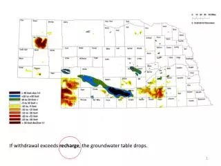
Estimating Groundwater Recharge Using the Oklahoma Mesonet. Sam Wallace Undergraduate, OSU Dept. Environmental Science Dr. Tyson Ochsner Assistant Professor of Soil Physics, OSU Dept. Plant and Soil Sciences. Source: Oklahoma Water Atlas, 1983. Groundwater Monitoring.

E N D
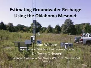
Estimating Groundwater Recharge Using the Oklahoma Mesonet Sam Wallace Undergraduate, OSU Dept. Environmental Science Dr. Tyson Ochsner Assistant Professor of Soil Physics, OSU Dept. Plant and Soil Sciences
Groundwater Monitoring • USGS monitoring wells/streamflow gauges • Real-time monitoring wells • Daily groundwater monitoring • Real-time stream flow gauges • Water Table Fluctuation Method • Water Budget Method
Groundwater Recharge Evaluation through Soil Moisture • Established statewide monitoring network • Long history of monitoring (since 1994) • Soil moisture monitoring at 5, 25, and 60 cm
Our Study • Five Mesonet stations: Acme, El Reno, Fittstown, Shawnee, Spencer • Chosen for availability of both soil moisture sensors and groundwater wells.
Methods • Mesonet temperature reference values converted to matric potential • Soil hydraulic parameters calculated using ROSETTA Source: Illston et al., 2008
Methods • Where: • q= water flux- groundwater recharge • K(Se)= hydraulic conductivity • Se= water content • h= matric potential • z= depth • θ(h) = volumetric water content θr = residual water contentθs =saturated water contentα = fitting parameter n = a measure of the pore-size distribution • K0 = a fitting matching point at saturation • L = empirical parameter • Volumetric Water Content • Effective Saturation • Hydraulic Conductivity • Buckingham-Darcy Equation
Results Table 1: Mean annual precipitation (P), drainage at 60 cm (D), and the ratio D/P for five Mesonet stations using data from 1999 through 2011. For comparison, prior estimates of the ratio of groundwater recharge (R) to P are also shown.
Discussion • Limitations in this new method • No upward water flow • Time lag varies with site, weather • Promising results • Comparable to historical averages • Calculated drainage events correspond to observed water table rises • As always, further research needed • Does this method work in the extremes of the state? • Mechanics of time lag Source: Wikimedia
Acknowledgements I would like to thank the following sponsors: • Oklahoma State University Freshman Research Scholars Program • Oklahoma State University Wentz Research Project • EPA Greater Research Opportunities for Undergraduates Fellowship