Download
1 / 85
850 likes | 872 Views
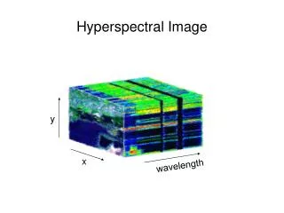
Hyperspectral DataAssimilation: -Status Progress. J. Le Marshall J.Jung. Overview. Background JCSDA Hyperspectral Radiance Assimilation Initial Experiments Recent Advances Summary and Future. Data Assimilation Impacts in the NCEP GDAS.

E N D
Hyperspectral DataAssimilation: -Status Progress J. Le Marshall J.Jung
Overview • Background • JCSDA • Hyperspectral Radiance Assimilation • Initial Experiments • Recent Advances • Summary and Future
Data Assimilation Impacts in the NCEP GDAS AMSU and “All Conventional” data provide nearly the same amount of improvement to the Northern Hemisphere.
The Joint Center for Satellite Data Assimilation John Le Marshall Director, JCSDA Deputy Directors: Stephen Lord – NWS /NCEP James Yoe - NESDIS Lars Peter Riishogjaard – GSFC, GMAO Pat Phoebus – DoD,NRL January, 2005
PARTNERS NOAA/NCEP Environmental Modeling Center NOAA/OAR Office of Weather and Air Quality NASA/Goddard Global Modeling & Assimilation Office US Navy NOAA/NESDIS Oceanographer of the Navy, Office of Naval Research (NRL) Office of Research & AF Director of Weather AF Weather Agency Applications US Air Force Joint Center for Satellite Data Assimilation
JCSDA Mission and Vision • Mission: Accelerate and improve the quantitative use of research and operational satellite data in weather and climate analysis and prediction models • Near-term Vision: A weather and climate analysis and prediction community empowered to effectively assimilate increasing amounts of advanced satellite observations • Long-term Vision: An environmental analysis and prediction community empowered to effectively use the integrated observations of the GEOSS
Goals – Short/Medium Term • Increase uses of current and future satellite data in Numerical Weather and Climate Analysis and Prediction models • Develop the hardware/software systems needed to assimilate data from the advanced satellite sensors • Advance the common NWP models and data assimilation infrastructure • Develop common fast radiative transfer system • Assess the impacts of data from advanced satellite sensors on weather and climate analysis and prediction • Reduce the average time for operational implementations of new satellite technology from two years to one
JCSDA Road Map (2002 - 2010) 3D VAR -----------------------------------------------------4D VAR By 2010, a numerical weather prediction community will be empowered to effectively assimilate increasing amounts of advanced satellite observations The radiances can be assimilated under all conditions with the state-of-the science NWP models Resources: NPOESS sensors ( CMIS, ATMS…) GIFTS, GOES-R OK Required Advanced JCSDA community-based radiative transfer model, Advanced data thinning techniques The CRTM include cloud, precipitation, scattering The radiances from advanced sounders will be used. Cloudy radiances will be tested under rain-free atmospheres, more products (ozone, water vapor winds) AIRS, ATMS, CrIS, VIIRS, IASI, SSM/IS, AMSR, WINDSAT, GPS ,more products assimilated Science Advance A beta version of JCSDA community-based radiative transfer model (CRTM) transfer model will be developed, including non-raining clouds, snow and sea ice surface conditions Improved JCSDA data assimilation science The radiances of satellite sounding channels were assimilated into EMC global model under only clear atmospheric conditions. Some satellite surface products (SST, GVI and snow cover, wind) were used in EMC models AMSU, HIRS, SSM/I, Quikscat, AVHRR, TMI, GOES assimilated Pre-JCSDA data assimilation science Radiative transfer model, OPTRAN, ocean microwave emissivity, microwave land emissivity model, and GFS data assimilation system were developed 2002 2003 2008 2009 2010 2007 2004 2005 2006
The Challenge Satellite Systems/Global Measurements GRACE Aqua Cloudsat CALIPSO GIFTS TRMM SSMIS TOPEX NPP Landsat Meteor/ SAGE GOES-R COSMIC/GPS NOAA/POES NPOESS SeaWiFS Jason Aura Terra SORCE ICESat WindSAT
NPOESS Satellite CMIS ATMS CMIS- μwave imager VIIRS- vis/IR imager CrIS- IR sounder ATMS- μwave sounder OMPS- ozone GPSOS- GPS occultation ADCS- data collection SESS- space environment APS- aerosol polarimeter SARSAT - search & rescue TSIS- solar irradiance ERBS- Earth radiation budget ALT- altimeter SS- survivability monitor VIIRS CrIS OMPS ERBS The NPOESS spacecraft has the requirement to operate in three different sun synchronous orbits, 1330, 2130 and 1730 with different configurations of fourteen different environmental sensors that provide environmental data records (EDRs) for space, ocean/water, land, radiation clouds and atmospheric parameters. In order to meet this requirement, the prime NPOESS contractor, Northrop Grumman Space Technology, is using their flight-qualified NPOESS T430 spacecraft. This spacecraft leverages extensive experience on NASA’s EOS Aqua and Aura programs that integrated similar sensors as NPOESS. As was required for EOS, the NPOESS T430 structure is an optically and dynamically stable platform specifically designed for earth observation missions with complex sensor suites. In order to manage engineering, design, and integration risks, a single spacecraft bus for all three orbits provides cost-effective support for accelerated launch call-up and operation requirement changes. In most cases, a sensor can be easily deployed in a different orbit because it will be placed in the same position on the any spacecraft. There are ample resource margins for the sensors, allowing for compensation due to changes in sensor requirements and future planned improvements. The spacecraft still has reserve mass and power margin for the most stressing 1330 orbit, which has eleven sensors. The five panel solar array, expandable to six, is one design, providing power in the different orbits and configurations.
5-Order Magnitude Increase in Satellite Data Over 10 Years Satellite Instruments by Platform Daily Upper Air Observation Count NPOESS METEOP NOAA Windsat GOES DMSP Count Count (Millions) 1990 2010 Year Year
GOES - R ABI – Advanced Baseline Imager HES – Hyperspectral Environmental Suite SEISS – Space Environment In-Situ Suite including the Magnetospheric Particle Sensor (MPS); Energetic Heavy Ion Sensor (EHIS); Solar & Galactic Proton Sensor (SGPS) SIS – Solar Imaging Suite including the Solar X-Ray Imager (SXI); Solar X-Ray Sensor (SXS); Extreme Ultraviolet Sensor (EUVS) GLM – GEO Lightning Mapper
Advanced Baseline Imager (ABI) Total radiances over 24 hours = 172, 500, 000, 000
Hyperspectral Environmental Suite (HES) (T) = Threshold, denotes required coverage (G) = Goal, denotes coverage under study during formulation
Hyperspectral Environmental Suite (HES) Total radiances over 24 hours = 93, 750, 000, 000
HIRS sounder radiances AMSU-A sounder radiances AMSU-B sounder radiances GOES sounder radiances GOES, Meteosat, GMS winds GOES precipitation rate SSM/I precipitation rates TRMM precipitation rates SSM/I ocean surface wind speeds ERS-2 ocean surface wind vectors Quikscat ocean surface wind vectors AVHRR SST AVHRR vegetation fraction AVHRR surface type Multi-satellite snow cover Multi-satellite sea ice SBUV/2 ozone profile and total ozone Altimeter sea level observations (ocean data assimilation) AIRS Current Upgrade adds; MODIS Winds… Satellite Data used in NWP
Short Term Priorities 04/05 • SSMIS: Collaborate with the SSMIS CALVAL Team to jointly help assess SSMIS data. Accelerate assimilation into operational model as appropriate • MODIS: MODIS AMV assessment and enhancement. Accelerate assimilation into operational model. • AIRS: Improved utilization of AIRS • Reduce operational assimilation time penalty (Transmittance Upgrade) • Improve data coverage of assimilated data. Improve spectral content in assimilated data. • Improve QC using other satellite data (e.g. MODIS, AMSU) • Investigate using cloudy scene radiances and cloud clearing options • Improve RT Ozone estimates
Some Major Accomplishments • Common assimilation infrastructure at NOAA and NASA • Common NOAA/NASA land data assimilation system • Interfaces between JCSDA models and external researchers • Community radiative transfer model-Significant new developments, New release June • Snow/sea ice emissivity model – permits 300% increase in sounding data usage over high latitudes – improved polar forecasts • Advanced satellite data systems such as EOS (MODIS Winds, Aqua AIRS, AMSR-E) tested for implementation -MODIS winds, polar regions - improved forecasts. Current Implementation -Aqua AIRS - improved forecasts. Implemented • Improved physically based SST analysis • Advanced satellite data systems such as -DMSP (SSMIS), -CHAMP GPS being tested for implementation • Impact studies of POES AMSU, Quikscat, GOES and EOS AIRS/MODIS with JCSDA data assimilation systems completed.
MODIS Wind Assimilation into the GMAO/NCEP Global Forecast System
Global Forecast System Background • Operational SSI (3DVAR) version used • Operational GFS T254L64 with reductions in resolution at 84 (T170L42) and 180 (T126L28) hours. 2.5hr cut off
2004 ATLANTIC BASIN AVERAGE HURRICANE TRACK ERRORS (NM) Results compiled by Qing Fu Liu.
AIRS/AQUA/ Assimilation Studies AQUA Initial Studies Targeted studies Pre-Operational trials First Second ……….
AQUA AIRS/AQUA Initial Studies
AIRs Targeting Study Contributors: GMAO: L.P. Riishojgaard, EMC: Zoltan Toth,Lacey Holland • Summary of Accomplishments • GMAO developed a software for stratifying observational data stream that indicates the area having higher background errors • EMC had some dropsonde data released in the areas found sensitive to Ensemble Kalman Filter technique where high impact events occurs. • Joint EMC/GMAO have identified 10 winter storm cases in 2003 that have large forecast errors for AIRS studies
SSI modifications • conservative detection of IR cloudy radiances • examine sensitivity, Tb, of simulated Tb to presence of cloud and skin temperature • those channels for which Tb exceeds an empirical threshold are not assimilated
Old thinning/weighting New thinning/weighting 90 E 270 E 90 E 210 E 210 E SSI modifications • more flexible horizontal thinning/weighting • account for sensors measuring similar quantities • specify sensor groupings (all IR, all AMSU-A, etc) • specify relative weighting for sensors within group
Motivation • Initially, computationally expensive to include all AIRS data in the GFS • Try to mitigate the effects by including a smaller subset of the data over ‘sensitive’ areas determined during the Winter Storm Reconnaissance (WSR) program • Why WSR? • Already operational (since 2001) • Geared toward improving forecasts of significant winter weather by determining where to place additional observations • Most years show improvement in 60-80% of cases targeted
How the impact of AIRS was evaluated • CASE SELECTION • 7 Cases selected from Winter Storm Reconnaissance (WSR) program during 2003 • Forecasts with high RMSE for given lead time chosen • DATA SELECTION • AIRS data assimilated only in locations identified as having the most potential for forecast improvement as determined through WSR (areas containing 90% or more of maximum sens. value) • Somewhat larger area covered by the AIRS data compared to WSR dropsonde coverage • EVALUATION • Impact tested by comparing two forecast/analysis GFS cycles (T126L28), identical except that one contains AIRS data while the other does not • Control has all operationally available data (including WSR dropsondes)
Data Impact of AIRS on 500 hPa Temperature (top left), IR Satellite Image (top right), and estimated sensitivity (left) for 18 Feb 2003 at 00 UTC Impact outside the targeted areas is due to small differences between the first guess forecasts. Sensitive areas show no data impact due to cloud coverage. • Light purple shading indicates AIRS data selection • Violet squares indicate dropsonde locations • Red ellipse shows verification region
Improved/Neutral/Degraded classification based on RMSE of forecasts verified against raobs over WSR pre-defined verification area
Overall impact of AIRS on WSR forecasts • determined by comparing the number of fields (temperature, vector wind, humidity between 1000-250 hPa as well as sfc pressure) that were improved or degraded for each case • While the addition of dropsondes shows a slight positive impact, the addition of AIRS data has no overall benefit
JCSDA RECENT STUDIES
AIRS Data Assimilation J. Le Marshall, J. Jung, J. Derber, R. Treadon, S.J. Lord, M. Goldberg, W. Wolf and H-S Liu, J. Joiner, and J Woollen…… 1 January 2004 – 31 January 2004 Used operational GFS system as Control Used Operational GFS system Plus EnhancedAIRS Processing as Experimental System
Table 1: Satellite data used operationally within the NCEP Global Forecast System
Global Forecast System Background • Operational SSI (3DVAR) version used • Operational GFS T254L64 with reductions in resolution at 84 (T170L42) and 180 (T126L28) hours. 2.5hr cut off
The Trials – Assim1 • Used `full AIRS data stream used (JPL) • NESDIS (ORA) generated BUFR files • All FOVs, 324(281) channels • 1 Jan – 15 Feb ’04 • Similar assimilation methodology to that used for operations • Operational data cut-offs used • Additional cloud handling added to 3D Var. • Data thinning to ensure satisfying operational time constraints