Download
1 / 13
130 likes | 150 Views
The National Geophysical Data Center (NGDC) in Boulder, CO, USA, is dedicated to preserving and providing access to marine geology and geophysics data. With a focus on data stewardship, NGDC rescues and digitizes data, participates in international partnerships, manages various types of sea floor data, and makes data freely available through access interfaces and tools.

E N D
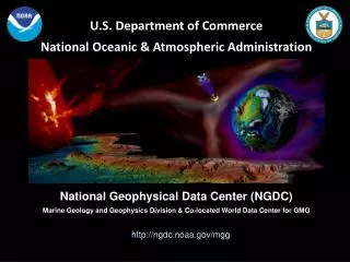
World Data Center for Marine Geology and Geophysics, Boulder, CO USAhosted by theNational Geophysical Data Center (NGDC) U.S. Department of CommerceNational Oceanic & Atmospheric Administration http://www.ngdc.noaa.gov/
Marine Geology and Geophysics Division NGDC provides scientific stewardship for data from the ocean floor, from both coastal and open ocean areas, and for data related to natural hazards including tsunamis.
Permanent Archive We’re in it for the Long Haul, Preserving data for your great-grandchildren • Archived in original and processed forms • Documented to FGDC/ISO standards • Periodically migrated to new/approved media NOAA/NGDC Commitment to Sea Floor Data Stewardship
Data Rescue & Digitizing Rescuing data from scientists’ desks and file cabinets. NOAA Climate Data Modernization Program (CDMP) • 29,881 core photographs/negatives scanned • 6,349 core X-rays scanned • 5,737 core logs and smear slide descriptions key-entered • 3,941 sea floor photographs scanned • plus seismic reflection data from the NGDC archives (materials digitized April 2005 through April 2007) NOAA/NGDC Commitment to Sea Floor Data Stewardship
International Partnerships & Project Participation • Integrated Ocean Observing System (IOOS) • Global Earth Observation System of Systems (GEOSS) • General Bathymetric Chart of the Oceans (GEBCO) & associated regional mapping projects sponsored by the IOC and IHO • Conducting IOC-sponsored international training in tsunami inundation DEM development • Managing the Index to Marine & Lacustrine Geological Samples database • Serving as a Bathymetric Data Assembly Center for the World Ocean Circulation Experiment (WOCE) • Cooperating with international projects like the Solid Earth Sample Registry (SESAR) and goSEABED NOAA/NGDC Commitment to Sea Floor Data Stewardship
Data Types Managed NGDC manages all types of data from the sea floor, including underway geophysical measurements, derived products and gridded databases, and descriptions and analyses of geologic samples. • NOAA/National Ocean Service (NOS) • hydrographic survey data & products • Trackline geophysical data • multibeam & single beam bathymetry • gravity • magnetics • seismic reflection • Marine sediment and rock analyses & descriptions • Gridded databases • Tsunami inundation DEMs • global and coastal gridded elevations • total sediment thickness of the oceans NOAA/NGDC Commitment to Sea Floor Data Stewardship
Data Scope & Mandate NGDC serves as the US National Repository for marine geological and geophysical data from the sea floor collected with public funds. Internationally, NGDC operates the World Data Center for MGG, Boulder, and the International Hydrographic Organization Data Center for Digital Bathymetry. NOAA/NGDC Commitment to Sea Floor Data Stewardship
Data Policies Making data freely and publicly available. Marine geological and geophysical data managed by NGDC are in the public domain and freely accessible unless restrictions are requested by the data contributor, usually a moratorium for a specified period of time. Most data are online, searchable, and free for download. Analog data and custom products are offered at the cost of reproduction. NOAA/NGDC Commitment to Sea Floor Data Stewardship
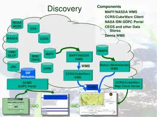
NOAA/NGDC Commitment to Sea Floor Data Stewardship Access Interfaces and Tools Making data freely and publicly available. • Geospatially-enabled relational databases • Interactive browse tools • Web Map Services • File download in multiple forms
NOAA/NGDC Commitment to Sea Floor Data Stewardship Example ArcIMS Interface: DEM Discovery Portal • Locate DEMs • View images • Link to DEM, Project, Source • Download data
Metadata Standards & Vocabularies Actively adapting & applying community standards. • FGDC-compliant metadata • ISO standards • Marine XML (MML) • GCMD Theme & Place keywords NOAA/NGDC Commitment to Sea Floor Data Stewardship
National Geophysical Data Center (NGDC) http://www.ngdc.noaa.gov/
![[The Virtual Radiation Belt Observatory]](https://cdn2.slideserve.com/5073406/the-virtual-radiation-belt-observatory-dt.jpg)