Download
1 / 11
110 likes | 132 Views
Enhancing biodiversity and connectivity through fine-scale planning in Robson Valley to protect ITR, focusing on species habitat and local economies. Establishing Rainforest Conservation Corridor for 14,000 km2 protection. Key areas and species conservation highlighted in 194,800 km2 ITR.

E N D
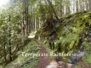
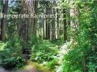
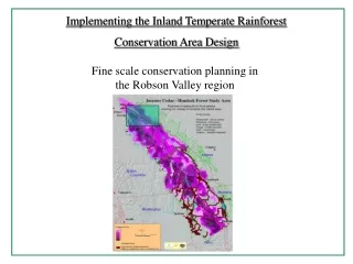
Implementing the Inland Temperate Rainforest Conservation Area Design Fine scale conservation planning in the Robson Valley region
Implementing and fine tuning the Inland Temperate Rainforest coarse level CAD on the ground, LOCAL AREA application of science-based rationale for species habitat and connectivity requirements supporting community-based interests to help local Rainforest communities maintain their quality of life helping to develop sustainable, alternative economies
Successful implementation and fine tuning the CAD in the Robson Valley is critically dependent on the establishment of a Rainforest Conservation Corridor that will ensure connectivity among 9 existing provincial parks.This would result in a 14,000 km2 contiguous protected area covering a major portion of the northern part of the Inland Temperate Rainforest. ITR “boundary” – 194,800 km2 Rainforest Conservation Corridor - 9,645 km2 Walker Rainforest Wilderness – 734 km2 9 parks area ~ 4850 km2 Corridor adds ~ 9050 km2 Total 13,900 km2 9,300 km2 of the ITR ( ~ 5%) (20 more local areas ?? to cover all ITR)
Preliminary ITR CAD composite core areas for our 6 species within the Robson Valley Rainforest Conservation Corridor Rainforest Conservation Corridor suitable primary habitat 6 species – 15% 5 species - 19 % 4 species - 12 % 3 species - 24 % 2 species - 22% 1 species - 5 % 0 species - 3% Approximately 70 % of the RCC supports 3 or more of our CAD focal species
The Robson Valley Rainforest Conservation Corridor • has some of the highest conservation values in BC • Some of the oldest cedar in BC Interior • Last Rocky Mountain watersheds where grizzlies still feed on wild ocean salmon • Highest density grizzly population in East Central BC • Many Antique Rainforest patches • Southern – most remaining Alberta caribou herd calving grounds • Endangered woodland caribou calving and wintering habitat • Eight large predator populations: grizzly bear, black bear,gray wolf,cougar, wolverine, lynx, bobcat and coyote • Bottleneck wildlife corridor used annually by many large mammals • Some 1500 spawning Chinook salmon • Last two remainng undeveloped ITR watersheds over 400 km2 with migratory salmon, bull and rainbow trout populations
to help implement the results of the Conservation Area Design in the Robson Valley region three focal elements within this Rainforest Conservation Corridor must be identified, documented and legally protected • some 1,000 km2 of new endangered Mountain Caribou Reserves • additional spatial OGMAs • Walker Rainforest Wilderness.
Old Growth Management Areas 2002-2003 269 sq. km (104 sq. mi, 66,443 acres) were legally protected as OGMAs, including more than 150 antique rainforest pockets 2004-2005 172 sq. km OGMAs was legally established in the Foster, Hugh Allan, Dawson, Canoe, Kiwa, McLennan, Swift, Tete, Bulldog, Dave Henry, Packsaddle, and Yellow-Jacket watersheds new government Order protected 1000 sq. km of new OGMAs between Sugar Bowl/Grizzly Den, Kakwa, and Ptarmigan Creek/Erg Mountain Parks 2006 A total of 350 sq. km (86,500 acres, 135 sq. mi) of new Old Growth Management Areas (OGMAs) were legally protected 2007 The coarse scale map to the right indicates the approximate areas deemed important enough for connectivity, to be added to the existing protected OGMA’s by the year 2007 Total OGMA’s to date -1,790 km2 The areas shown in green would add some 1000 km2 for a total of ~ 2,800 km2 of legally protected old growth in the Rainforest Conservation Corridor
Caribou Reserves Heading for extinction 2002-2003 a total of 2,808 sq. km (1,084 sq. mi) of Endangered Mountain Caribou habitat became legally protected winter range - habitat for more than 20 mountain caribou herds legally protected by law. This included the 250 sq. km Bearpaw Ridge Grizzly Area where up to 25 grizzlies have been seen feeding on anadromous Chinook salmon 2004-2005 The new government order which protected 1000 sq. km of new OGMAs between Sugar Bowl/Grizzly Den, Kakwa, and Ptarmigan Creek/Erg Mountain Parks included more than 53% of the original ICHvk,wk Rainforest ( the most productive caribou winter habitat) and most of the Mountain Caribou habitat within these and other watersheds, all within the Rainforest Conservation Corridor 2006 Some 200 km2 of the OGMA’s protected included Mountain Caribou habitat, including the calving-grounds for Alberta’s southernmost-remaining, unprotected Caribou herd within the Morkill watershed 2006 –2007 Identify remaining significant winter and summer caribou habitat areas within the Rainforest Conservation Corridor and incorpaorate these with existing protected areas. Back-dropping with the coarse level ITR CAD, confirm local level, optimal habitat/ connectivity areas, and hopefully review in terms of habitat spatial optimization and potential bottleneck situations.
caribou sightings within the RCC • areas identified as important caribou winter habitat within the RCC • This information needs to be incorporated into the local area Robson Valley core area/ connectivity analysis
Walker Rainforest Wilderness • 734 km2 of pristine wilderness • 400 km2 of intact old growth forest • 230 km2 sub-alpine/ alpine • < 4 km2 high elevation rock and ice OGMA’s and Caribou reserves now protect a large portion of the WRW. These protected regions need to be integrated into the fine scale optimal habitat/connectivity analysis for the Rainforest Conservation Corridor • Suitable primary habitat for all six focal species identified in the preliminary CAD for the ITR exists within the Walker Rainforest Wilderness • 6 species - 5 % • 5species - 46% • 4 species - 31 % • 3 species - 10 % • 2 species - 8 % • Approximately 92% of the WRW provides suitable primary habitat for 3 or more species
Specific tasks for on the ground CAD implementation/ fine tuning • Collaborative Work • consult/work with local rainforest communities/ experts, other • conservation organizations, scientists, government and • interested menbers of the public • Data Collection & Research • identify additional caribou reserves and OGMA’s areasincluding the large • Walker Rainforest Wilderness • collect and analyze ( in a GIS geo – referenced database) ecological information needed to • refine CAD coarse scale habitat/connectivity within the contiguous • Rainforest Conservation Corridor • Develop a Conservation Strategy • provide campaign and educational materials • advance results to government agencies • dovetail results with overall Inland Temperate Rainforest Initiative (IRI)