Download
1 / 23
230 likes | 323 Views
Explore the use of EPS to evaluate uncertainties related to Tropical Cyclones impacting container vessels, focusing on route optimization, weather advice, and decision-making strategies. The case of the Marchen Maersk voyage from Los Angeles to Yokohama in 2009 highlights the importance of leveraging EPS data for safer navigation.

E N D
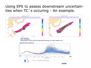
Using EPS to assess downstream uncertain-ties when TC´s occuring - An example.
Outlines: • In which way can we use EPS to obtain a qualitative impression of the uncertainties regarding TC´s and their extratropical stage? • Can this aid us in early decision making when we know the operation criteria limits? • Can this give example give an approach towards a more generel methodology?
Container vessel Marchen Maersk sailed from Los Angeles to Yokohama 2009 October 7th-21th:
1) Avoid Heavy Weather Damage:2) Most economic route3) Fastest route Limit of sig. waves for this voyage about 6m. Fin stabilizer Missing Fin stabilizers Millions of USD lost…
Weather routeing request: • Requested service: Weather routeing • Company name: A.P.Møller Mærsk • Ship name: Marchen Mærsk • Imo no: 9359014 • Call sign: OUIY2 • Inmarsat no: +870 763 747 691 • E_mail ship: mbxmarchen@maersk.com • Dept port: Los Angeles • Dept country: USA • Etd date (utc): 06.Oct.2009. • Etd hour (utc): 2359 • Arr port: Yokohama • Arr country: Japan • Eta date(utc): 21.Oct.2009. • Eta hour(utc): 1600 • Service/eco speed: Service speed is 25kn • Gmt: 3m Expected • Displacement: 101000mt • Fin Stabilizer yes/no: No • Remarks/requirements: I expect to run with required speed in order to be • as economical as possible.
Routes: RL=5030nm GC=4750nm GC via Bering Sea (Unimak Passage/Attu Island)=4850nm
TC activity enroute: 1) Typhoon ”Melor” (a reality by time of departure) 2) Possible developments east of the Philippines
1st advice (6/10): GC via Unimak passage to north of Attu Island for Yokohama. • Motivation: Passing safe north of ”Melor” the 12th and later getting mainly north of the lowtrack. • Synopsis main feature: …”Typhoon ”Melor” was the 6th/06:00 located at 23.9n/130.9e and is currently moving n-wards about 15kt, later ne- to e-wards becoming extratropical during the 9th th and most likely taking a track along 48-50n without causing you troubles..”
Iteration 7th/00z +24hr = 8th/00z +48hr = 09/00z +72hr = 10/00z +96hr = 11/00z
Daily evaluation of the forecasts • Checking significant changes in the forecasts from day to day • Forecasts from the 8th almost similar to the ones from the 7th, except for…: • A tropical depression is detected east of the Philippines
New ”Dangerous” forecast valid 15th/12z!! Deterministic run based on Iteration 9th/00z
EPS – Significant wave – Valid 15/12:00Z Forecast base time 9th/00z 35-65% Example (95-100%) +6m
Recently detected TD 23w (Oct 8th), later TS ”Nepartak”, viewed in ECMWF´s ”Strike Probability Map” October 9th/00z
Preliminary route alternate: Dangerous area 15th of oct. Deviation point 51n/150w Vessel pos 9th of oct. +6m (35-65%)
2nd advice (9/10): Now GC via 51n/150w, thence until further GC south of the Aleutians via 50n/175e for Yokohama. • Motivation: Waiting until apprx. 150w (11th/AM where the situation hopefully has become less unsettled, then probably deviating just south of the Aleutians due to a long-term forecasted, northgoing strong gale- or storm low just south Kamchatka during the 14-15th – with risk of + 6m seas. • Synopsis main feature: ..” Former typhoon "Melor” became officially declared extratropical the 09/06:00 at 44n/150e and now continues e- to ene-wards along 49-50n - forecasted the 12th/12:00 near 50n/157w and just after passing south of you. Revert- ing with further details about the possible strong low south of Kamchatka in our next update, by the latest October the 12th.
Ex-”Melor” Ex-”Melor” Iteration 9th/00 +24hr = 12/00z +48rs = 13/00z l +108hr = 15/12z +72hr = 14/00z
ECMWF Cyclone Tracker / SPM starting up when a TD is detected. Nepartak 9th-11th:
Wave Epsgram from Oct 10th/00z EPS members suggest more northerly track
”Nepartak” life cycle October 8th-14th close to the 11th/00z iteration TD ”23W” first detected 8th/12:00 Upgraded to TS ”Nepartak” the 9th
Surface map the 15th/12:00 – iteration 11th/00z far better than the 9th/00z run
3rd advice (11/10): Now proceed GC via Unimak passage to north of Attu Island for Yokohama. • Motivation: • The recent uncertainties regarding seas about 6m via Unimak-Attu route, caused by tropical cyclone activity south of Japan (Nepartak), has now reduced significantly and it seems quite confident that "Nepartak" will pass safe south of the vessel. • Synopsis main feature: ..” Former typhoon "Melor", now an ordinary extratropical low near 49n/162w continues e- later- ese-wards, passing just south of you the 12th/AM, while ene-going (ex-) ”Nepartak" passes well south of you along 42-45n the 15th/PM (please note that there is a still risk of a slight more northerly track)”..
Summary: • In which way can we use EPS to obtain a qualitative impression of the uncertainties regarding TC´s and their extratropical stage? Compare various plots of EPS including spatial- and time related aspects of the development. • Can this aid us in early decision making, when we know the operation criteria limits? Setting up a specific deadline to take action in order for a given parameter not to be exceeded or event to take place (binary=yes/no) will help us doing this (for exampletake action when probability > 35% after T+xx hrs) • Can this give example give an approach towards a more generel methodology? Any parameter can be involved, for example temp>30 deg, 10m winds>25 m/s, precipitation>20mm/6hrs. Knowledge about the models ability to predict the phenonomen must be known.