Revolutionizing Aerial Surveys: A3 Digital Mapping's Breakthrough in Speed and Coverage
The A3 Digital Mapping System represents a leap forward in aerial survey capabilities, boasting the largest pixel footprint and fastest processing times available in the industry. Responding to the needs articulated at ASPRS 2012, our system offers high-resolution statewide four-band coverage and efficient oblique imagery collection. With the ability to deliver dense surface models promptly—even within two weeks of data collection—A3 meets critical demands for expansive coverage and rapid turnaround. Experience unmatched efficiency and versatility in photogrammetric products with A3.

Revolutionizing Aerial Surveys: A3 Digital Mapping's Breakthrough in Speed and Coverage
E N D
Presentation Transcript
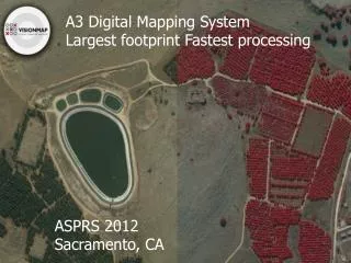
A3 Digital Mapping System Largest footprint Fastest processing ASPRS 2012 Sacramento, CA
What’s Required? “We had less good weather days last year” – Larger coverage is needed. “We need to turn around the data two weeks after we started flying” – Faster processing is required. “We need dense surface model” – Surface models for large areas are required when not already available. “Can we do obliques efficiently?” - New requirements for photogrammetric products emerge.
A3 Delivers • A3 family features the largest pixel footprint across track- • A3 Edge covers 80,000 pixels across • A3 covers 60,000 pixels across • A3 Core covers 40,000 pixels across • LightSpeed features the fastest processing • Quick turn around of data • Multiple products • One workflow operated by a lean team
Thank You! www.visionmap.com