Download
1 / 28
300 likes | 456 Views
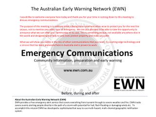
The Australian Early Warning Network (EWN). I would like to welcome everyone here today and thank you for your time in coming down to this meeting to discuss emergency communications.

E N D
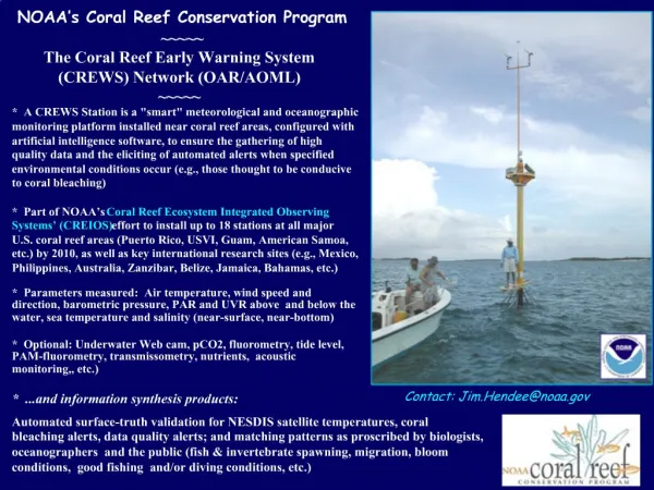
The Australian Early Warning Network (EWN) I would like to welcome everyone here today and thank you for your time in coming down to this meeting to discuss emergency communications. The purpose of this meeting is to address what is being done communication-wise to protect you for the next fire season, not to mention any other type of emergency. We are also pleased to be able to take the opportunity to announce what we can offer your community, at no cost. This is something unique, not available any where else in the world and designed specifically to save lives protect property and make you safer. What we will show you today in the mix of other communications that you need, is a cutting edge technology and a service that has been pioneered here in Australia and is proven to work. Emergency Communications Community Information, preparation and early warning www.ewn.com.au Before, during and after About the Australian Early Warning Network (EWN) EWN provides a free emergency alert service that covers everything from tsunami through to severe weather and fire.EWN tracks severe events alerting people directly in the path of a storm with potential for hail, flash flooding or damaging winds etc. To accomplish this mission EWN has developed a sophisticated but easy to use multi-hazard, multi-channel geographic notification system.
Emergency Communications For Your Community As just mentioned, while fires are a continual threat, we never know what the next crisis will be • Communications to manage multiple hazards • Fire • Biological- Pandemic threats • Severe Weather • Criminal, Terror • Other www.ewn.com.au
We all know that in the recent tragedy that communications were a major problem We know the community did not get enough information, could not find it and did not receive adequate warning. We aim to make sure that never happens again We aim to do that by making sure you, your community is in control of the apparatus that gets those warning to you
Information and Warnings In all emergencies your community needs time to prepare, it needs timely warning with information that is accurate for where individuals live or work because what happens at one house or street might be entirely different to another. You need to be kept informed during and after events. This is also where layers of communication come in to overcome failures . • Media – Radio, TV, internet • Word of mouth • NEWS – the National Early Warning System • Radio • LEN – Local Emergency Networks (Multi-channel, multi-hazard) • Landline • SMS • email • desktopALERT This is opt-in. The benefit of this is people have requested to be informed and controllers will not be constrained by bureaucratic concerns. Their job is to keep you informed www.ewn.com.au
NEWS – The National Early Warning System. This is a necessary and essential layer and is supposed to be ready in time. This is the system being provided by Telstra funded by $15M from the federal government plus an annual maintenance fee. • It uses IPND – mobile, landline only based on billing address • Is it location based in other words GIS? Don’t know • Protocols – When is it used…Emergency Warning Signal? • Who uses it, who will have authority to send alerts? • What we do know is irregardless of this, you will have a system you can control that exceeds any other capability is operating today.
Who Are We? The Australian Early Warning Network (EWN) provides a free emergency alert service to the public and business covering everything from tsunami through to severe weather. Alerts are sent via SMS, phone, email, desktopALERT™ and web. EWN tracks severe events alerting people directly in thier path such as a storm with potential for hail, flash flooding or damaging winds and fires etc. To achieve this EWN has developed and operates a multi-channel Geographic Notification and Information System (GNIS). This system instantly and simultaneously broadcasts alerts and notifications to individuals, groups, or persons in selected areas over multiple communication mediums. The GNIS is one of, if not the most advanced EW system in the world. The GNIS is proven and sends tens of thousands of alerts within Australia each month making it the most experienced service in use today. Worlds only operational location based severe weather early warning system. And it can send to one or one million all at once. As mentioned, this is what we offered free to the VIC government in 2007. It has been operational ever since and was sending alerts on Black Saturday.
Local Emergency Networks Headed by Mike Bath here – General Manager Alerts EWN’s national early warning centre manages alerting for severe weather events, tsunami and distribution of alerts produced by emergency authorities. Events such as fires and flooding require local knowledge to be effectively responded to. We believe in community resilience and want to arm your community with the means to defend itself. Our system has been specifically designed to meet that need and put you in control, not someone else….. Subsequently we have established Local Emergency Networks, run by locals for locals and have armed them with what we believe to be one of, if not the most powerful and sophisticated toolkits available to any community in the world to help monitor, warn and inform the community in any emergency. We will back this up, support your LEN’s where required from the Alerts Centre and co-ordinate team the many LENs to support and back up each other. The service and technology you are about to see is operating nationally now and includes some unique capabilities that you will see are extremely helpful to responders as well as the public – including the ability to locate and communicate with people and assets in real time www.ewn.com.au
Local Emergency Networks How does this actually happen, what do the local Emergency Networks do to send alerts Notifications or alerts can be sent using one of four methods: GIS Group Quick Saved alerts GIS Alert A GIS alert, as in the example to the right, is where an operator or alert manager selects or draws an alert area on the map. After creating the message and selecting the channels in which to send it through, everyone registered within that area will be alerted. Group Alert A group alert is sent to pre-defined lists. Quick Alert A quick alert is used to send to individuals or groups selected from a directory. Saved Alert This is an alert that is saved, normally setup up for an area or community that is vulnerable to a known risk. Saves time and confusion in emergency situations. We use mostly GIS alerts, responders might opt for something completely new we have developed based on real time location OR..If we were provided access to the IPND, everyone would get notified. The vulnerable – say in heat stress situations, childcare facilities, responders etc. Fast way to get to people using an address book and multiple channels Bushfire Alert sent by EWN to Marysville on Black Saturday
Geospatial Data Controllers and alert operators also enjoy other data in real time to help them target alerts To increase the accuracy of alerts, other geospatial data is overlayed in real time into the GIS control panel. Weather radar, wind direction, temperature, humidity
Example: This is what EWN does every day, the most common and pervasive threat; severe weather. Specifically through our 24/7 monitoring we alert on hail, flash flooding, strong winds.
Report of Snap Alert Example: This shows part of a system report of a multi-channel alert, one of many sent out on that particular evening. The alert is specific to the area of threat. Each icon represent s many members. The system records details of every alert and the complete history of alerts and messaging for each member.
Locating and Communication We are also pleased to be able to provide another new and very exciting capability. This has been made possible by partnering with Pocket Life and enables both mobile alerting and location capabilities For instance, controllers and responders will have access to to the system to ascertain the location of assets and communicate with them. This is achieved through the handset where the holder can elect to update its position every five minutes, ten..whatever they decide. The asset will show up on the map and will also show who it is and where it has been.
Locating and Communication For instance, controllers and responders will have access to to the system to ascertain the location of assets and communicate with them. This is achieved through the handset where the holder can elect to update its position every five minutes, ten..whatever they decide. The asset will show up on the map and will also show who it is and where it has been.
Locating and Communication For instance, controllers and responders will have access to to the system to ascertain the location of assets and communicate with them. This is achieved through the handset where the holder can elect to update its position every five minutes, ten..whatever they decide. The asset will show up on the map and will also show who it is and where it has been.
Locating and Communication For instance, controllers and responders will have access to to the system to ascertain the location of assets and communicate with them. This is achieved through the handset where the holder can elect to update its position every five minutes, ten..whatever they decide. The asset will show up on the map and will also show who it is and where it has been.
Locating and Communication For instance, controllers and responders will have access to to the system to ascertain the location of assets and communicate with them. This is achieved through the handset where the holder can elect to update its position every five minutes, ten..whatever they decide. The asset will show up on the map and will also show who it is and where it has been.
EWN partners with Pocket Life to use secure and real time location data from the mobile phone Location Data EWN Web Situation Room GPS Cell Tower* WiFi* *not scope of trial phase
The service works on over 50+ common handsets and will be rolled out further in the next weeks iPhone Nokia GPS Android Blackberry Mobile network
Other Types of Alerts Example: This example uses the radius tool to clear/warn an area or specific building to a bomb, biological or chemical threat.
Any size, shape alert areacan be drawn Accurate to within ten metres you can draw whatever shape and zoom down to alert just one house
Anyone, Anywhere, Anytime Port Moresby, Papua New Guinea
Registering to the System In other words how do people get onto the system to get alerted Directories or address and contact details can be imported and automatically geo-coded by the system, or people can go online and register. The public can go to our registration page enter their locations – home, work, schools etc. They are provided a login so they can manage their data, edit, add, delete turn off and on locations (ie boating/golf venues), protect kids etc.
Registering to the System Part of the registration and login page where members can manage their alert locations, types of alerts and history. Geo-coding
Join Other Groups Amber Alerts I mentioned other types of alerts. The system is designed to be used and exploited by the community. As other groups join and we offer other notifications, You can select to get these other alerts (Or turn them off and on) Select other alerts to receive such as Graziers alerts and other rural alerts Schools Child Care centres Aged Care facilities Others using the system include: Councils Aged Care facilities Schools Surf Life Saving Corporates Insurance Company We hope many more join We call these content providers
What I have just shown you a very brief over view. There is much more to the system and much, much more coming online over the next days. In closing, I want to say all of this has been pioneered and developed here in Australia. It has been funded entirely from our own pockets without any support from government. Indeed government seem to have tried particularly hard to avoid any recognition of us or the capability and benefit this system and service has to the community. We find this disappointing but it makes little difference to our commitment. On a personal note, and I’m sure many of you will understand, as you grow older it seems unavoidable..inevitable that tragedy, often horrific embraces you. While not having suffered through Black Saturday I do know the pain. This is why I am in no way going to stand back and let anyone suffer again when we have a tool that can prevent that.
Simultaneous Multi-Channel Alerts Email and desktopALERT Internet or any other electronic gateway SMS Text to voice phone or mobile Desktop Pop Up