Download
1 / 41
560 likes | 2.9k Views
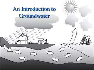
An Introduction to Groundwater. Groundwater Topics. The occurrence of groundwater. Well construction. Useful data to collect. Groundwater / Drinking water protection. Groundwater Basics. Where does ground-water come from? How does ground-water occur?

E N D
Groundwater Topics • The occurrence of groundwater. • Well construction. • Useful data to collect. • Groundwater / Drinking water protection.
Groundwater Basics • Where does ground-water come from? • How does ground-water occur? • How does ground-water move, what direction and how fast does it travel? • How susceptible is groundwater to contamination?
Important Groundwater Facts • Groundwater originates from precipitation sinking into the ground from the surface to the water table. • Groundwater occurs in the open spaces between silt, sand and gravel particles or in natural fractures in rocks (not underground rivers or lakes). • Groundwater moves from where the water table is high to where it is low. • How fast it moves depends on aquifer permeability. • Groundwater is susceptible to contamination from surface activities.
Aquifers • Once water reaches the saturated zone it is called groundwater. • If the geologic material of this saturated zone is permeable and can yield water to a well in sufficient quantity to supply user needs, it is referred to as an aquifer. • Aquifers can be either unconfined or confined.
Types of Aquifers • Unconfined • Shallow • Local Recharge • Water Table • Susceptible • Confined • Deeper • Confining Layer • Distant Recharge • Water under pressure • Less susceptible
Alluvial Aquifer: Valley Fill Stream Alluvium Bedrock Bedrock High yield High/Local recharge rate
Bedrock Aquifers • Fractured bedrock • Water in cracks • Low/High yield • Low/High recharge rate • “Dry” holes • Layered volcanics • Water between flows • High yield • Low recharge rate
Groundwater Flow • A common misconception – groundwater does not flow in underground rivers. • Instead, groundwater exists within the saturated zone in pore (open) spaces and travels by seepage (percolation). • How easily water travels underground is a function of the type of sediment present. • Permeability: gravel > sand > clay
Groundwater Levels • Groundwater levels fluctuate over the course of the year, especially in shallow aquifers. • Generally, groundwater levels rise during the high rainfall,winter months and fall during the drier summer months. • Additionally, the higher level of pumping of wells in the summer impacts groundwater levels of wells through drawdown.
Groundwater Composition: Variability Between Wells • Recharge and/or source related • Wells screened in different aquifers • Wells screened at different depths in the same aquifer
Seasonal Compositional Variations • Seasonal Differences within a single well • Recharge related • Infiltration of nitrate from a nitrate source (A) • Dilution of contaminated aquifer (B) • Significant Variations • Up to 100% have been observed, e.g., <10 to >20 mg/L B A
Useful Data to Collect • Down hole video log (at construction). • Spinner log (at construction). • Static water-levels (minimum of spring and fall). • Aquifer test to calculate specific capacity of well (gpm/drawdown – annually). • Monthly water use. • Major ion chemistry. • Sodium, Calcium, Potassium, Magnesium. • Sulfate, Chloride, Bicarbonate, Carbonate.
What is a Source Water Assessment? • Delineation • Groundwater: Identification of the land area above the well or spring’s capture zone (DHS) • Surface Water: Identification of the subwatershed area above intake (DEQ) • Inventory of Potential Contaminant Sources • Determination of the susceptibility of the drinking water source to the PCSs • Written Source Water Assessment Report
GPS Well Site DWPA • Necessary to have gps coordinates in latitude longitude • Correct Well location on map relative to the drinking water protection area (DWPA) Well
What is the Datum? • In order for the well location to properly register on the map, latitude/longitude location of well must be relative to the same datum as the map. • Record as NAD1927 or WGS1984
Procedures for Delineation: Groundwater • Identify that part of the aquifer that supplies water to the well or spring • Site-specific parameters • Radius a function of time • Project to the surface
“Potential contaminant source” • a location where there is any activity having the potential to release one or more contaminants into water at a concentration of concern • Database queries (14), field locating in sensitive areas, PWS consultations • 96 separate categories of PCSs • As of 7/05, over 15,300 PCS locations have been identified • focus must be on HIGHER risks
Drinking Water Protection Process for Public Water Systems (PWS) DHS and DEQ contact PWS;GPS intake or well and request PWS assistance Activate community citizens, gather input, select a few strategies for protecting the source area DELINEATIONof the source area or “Drinking Water Protection Area” INVENTORYfor “Potential Sources of Contamination” per guidance Source Water ASSESSMENT phase OPTIONAL: Consider writing a Drinking Water Protection Plan and gaining certification from DEQ Drinking Water PROTECTION phase DetermineSUSCEPTIBILITY to contamination IMPLEMENT the strategies to prevent contamination SOURCE WATER ASSESSMENT REPORT Sent to PWS
Source of Information • Source Water Assessments: 1996 Amendments to Safe Drinking Water Act • Purpose of SWAs: To provide information water systems need to protect their resource • Identification of drinking water source area • Inventory of potential contaminant sources • Determination of the susceptibility of the drinking water to those PCSs • Most Oregon PWSs have received reports
Oregon drinking water source areas for surface water intakes
Oregon Drinking Water Protection Areas from Groundwater Sources
Developing Protection Strategies • Use Source Water Assessment to identify high- and moderate- risks. Update list • Risk factors • Aquifer sensitivity • Evaluate based on • Benefit achieved (risk reduction, economic factors) • Challenges (time, staff, cost) • Community buy in • Long-term plans • Associate appropriate BMPs with each identified risk
Summary • Source Water Assessment Reports help identify potential threats to drinking water quality. • The goal of Drinking Water Protection is to reduce the risk of contamination, not necessarily eliminate it • DEQ/DHS can assist public water systems prioritize their protection efforts and identify specific strategies • Drinking Water Protection in Oregon is voluntary but is necessary in order to protect existing and future drinking water sources.