Water Sustainability Solutions for Jagatpura, India: Addressing Scarcity Through Innovative Methods
Jagatpura, a village in Madhya Pradesh, faces severe water scarcity, reliant on a short monsoon season. Women travel long distances to fetch water, highlighting a critical need for sustainable solutions. This study explores options such as rooftop water harvesting, contour trenching, and macro-catchment systems to enhance water availability. Comparative analyses of these methods will evaluate their effectiveness and feasibility, informing future initiatives. Our research aims to empower the community with strategies to manage water resources better and ensure long-term sustainability.

Water Sustainability Solutions for Jagatpura, India: Addressing Scarcity Through Innovative Methods
E N D
Presentation Transcript
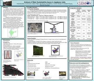
Analysis of Water Sustainability Issues in Jagatpura, India Holly Burwinkle, Scott Carroll, Kathryn Hajdu, Sam Murray, Tice Welborn, Jennifer Oblinger, Dr. Stephen Moysey, Clemson University Abstract Jagatpura, Madhya Pradesh is a small village in India subject to a monsoon season during June through September. There is very little rainfall during the rest of the year and the wells near the village dry up within three months of the monsoon season. As a result, the women of the village have to travel several kilometers to collect water for their households and livestock. Research is being conducted to uncover potential solutions to this problem. The potential solutions we have identified are rooftop water harvesting, a macro-catchment system, contour trenching, or a combination of any of these. Further research will be done to determine the viability of each of these potential solutions. Some factors that will affect the success of the solution are effects on the surrounding watersheds, costs of the potential water system, how long the water supply will last after the end of the monsoon season. Possible Solutions Comparative Analysis • Rooftop Water Harvesting • There are two different possibilities for the rooftop design, harvesting the rainwater for personal use or recharging the watershed with the collected runoff from the rooftops. If it’s assumed the village needs an additional 850 m3 of water per year(10L per person per day; 500 people; 170 day supply depleted), the rooftop area needed to collect that much water is 12,297 ft^2. • The potential supply of water is: • Supply = Rainfall (m/year) * Area (m^2) * Efficiency Coefficient • Typical rainfall year: Supply = (0.93 m/year) (1852 ft2) (0.0929m2/ft2) (0.8) = 128m3 15% of demand • High Rainfall Year: Supply = (1.10 m/year) (1852 ft2) (0.0929m2/ft2) (0.8) = 151m3 18% of demand • Low Rainfall Year: Supply = (0.50 m/year) (1852 ft2) (0.0929m2/ft2) (0.8) = 69m3 08% of demand • Reduced demand for the town would be 722 m3/year. Figure 5: Google Earth image of Jagatpura imported into GIS to calculate rooftop area Figure 6: Design for rooftop water harvesting system Figure 1: Map of India • Contour Trenching • Contour trenching is the digging of shallow ditches on a slope to slow runoff and increase absorption into the ground. • The absorbed water recharges the groundwater increasing the yield of wells down slope. • Jagatpura is located on a high point, contour trenching would benefit wells down slope from the village. • Contour trenching here may increase the longevity of wells in and around the village. • Introduction • Demographics • Population: 500 • Avg. Rainfall: 500mm to 1100mm (98% during monsoon season) • Principle water source: 500m or more away • Agriculture is major occupation of villagers • Women are domestic water managers, but have little to no voice in decision making processes • Future Research • Develop a conceptual model which will measure the impact of the potential solutions on the watershed and the surrounding environment • Determine the approximate size and cost of the earthen dam / contour trenches • Determining the size / holding capacity will allow for the exact amount of water captured by each to be measured • Exact monetary costs will allow for better comparison between systems • Develop an education / training program to implement with the selected system to help the villagers manage their water resources Figure 7: Contour trenching at the base of a hill in the Jagatpura area. Figure 8: Elevation map of the region and possible areas for contour trenching. Figure 3: GIS map of geology the in Jagatpura region Earthen Dam Figure 2: Average monthly rainfall for the Jagatpura area from 1980-2002. References and Acknowledgements We would like to thank the Foundation for Ecological Security and the International Water Management Institute for providing us with geological and background information about the village of Jagatpura. Kulkarni, H., Deolankar, S.B., Lalwani, A., Joseph, B., Pawar, S. Hydrogeological framework of the Deccan basalt groundwater systems, west-central India. Hydrogeology Journal 2000. India Water Portal (www.indiawaterportal.org) Sharma, Lalit, Sehgal, Jay, Mubashir, Ellora. Sustainable Rural Water Management: A Replicable Case Study. The Sehgal Foundation 2006. indiawaterportal.org Figure 4: Conceptual model of geological layers Figure 9: Dam in the Alwar district, Rajasthan Figure 11: A check dam in Dahod built by the Sadguru Foundation. Figure10: Proposed location of dam in Jagatpura watershed.