Download
1 / 18
180 likes | 311 Views
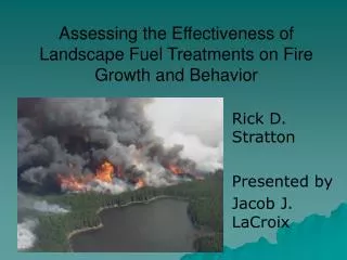
Assessing the Effectiveness of Landscape Fuel Treatments on Fire Growth and Behavior. Rick D. Stratton Presented by Jacob J. LaCroix. Introduction. Problem fires: Due to recent costly fire seasons 2000, 2002 Fuel modifications/protection strategy Urban/wild land interface

E N D
Assessing the Effectiveness of Landscape Fuel Treatments on Fire Growth and Behavior Rick D. Stratton Presented by Jacob J. LaCroix
Introduction • Problem fires: Due to recent costly fire seasons 2000, 2002 • Fuel modifications/protection strategy • Urban/wild land interface • Catastrophic fire in sensitive wild areas • Answer: fuel treatments = change fuel composition, structure and loading • Misconception: fuel treatments stop fire • Purpose is to change the behavior of a fire entering a fuel altered zone • Manifested by a reduction in FML, FLI, ROS, slower growth • Fragmenting fuel complex and disrupting local fire growth to increase suppression effectiveness • Best methods: Prescribed fires and thin-pile-burn
Overall Objective • Present a methodology for assessing the effectiveness of landscape fuel treatments on fire • Why: Cannot test with real fires • Models can test weather, treatment method, completeness of the application, treatment design • Placement • pattern • size
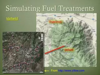
Analysis Area: Ash Creek Utah North: Urban Communities South: BLM, private and state land East: Interstate 15 West: Dixie National Forest, and Pine Valley Mountain Wilderness Area Wind: north/south direction e.g. Ash Creek Fire Elevation: East; 6,400ft West; 10,000ft New Harmony Harmony Heights Interstate 15 Ash Creek Project Area Gas Line Power Line Ash Creek Fire (1996) Aerial view of the Ash Creek project area looking northeast (postreatment). Photo by Paul Briggs.
Project Objectives • Apply fuel treatment to Ash Creek Project Area: • To reduce fire intensity, occurrence of crown fire, mid/long range spotting • To increase native plant diversity and enhance wildlife forage • Fuel treatment methods: • Herbicide application, Fuel reduction • Sage = herbicide, Juniper = manually cut, (lop and scatter) then pile and broadcast burning (Stephens 1998 and Van Wagtendonk 1996)
Methods: Model Summary • Compare pre and post treatment landscapes with computer models • Looking at previous fire locations, historical weather, fire growth and behavior models • FireFamily Plus: • fire climatology and occurrence program • FARSITE: • Fire area simulator • FlamMap: • uses *.LCP, every pixel burns/independent, no predictor of fire movement across a landscape, weather and wind are held constant • Landscape comparisons, pre and post, identifying hazardous fuels and topographic combinations, aids in prioritizing and assessment
Methods: FireFamily Plus Into FARSITE As you move to the right: Moisture decreases, Temperature increases, RH decreases, Wind speed increases, fire has an easier time.
Methods: FARSITE Inputs • 5 layer GIS map • Aspect, Elevation, Slope: DEM (Landsat ) • Canopy Cover • Fuel Layer • (Anderson 1982 with adjustments and custom model 14-50) • Calibration against 2 real fires • 2 climate files • Weather and Wind/initial fuel condition (FireFamily) • Simulations: (FARSITE) • Historically high location/repeated • Without suppression, 1 day duration, 1100-1900 burn period • 75th, 85th and 95th weather and fuel conditions • Imported into FlamMap
Results: Most representative 85th Conditions Post-treatment Pre-treatment Figure 2. Eight-hour FARSITE simulation for the 85th percentile weather and fuel condition. Each color represents a 1-hour progression of the fire overlaid with roads (black) and the treated landscape (light yellow). Black Ridge is in the foreground and the Pine Valley Mountains in the background (NW). Fuel modifications reduced the size of the fire by approximately 1,500 ac (18%).
Results: Before and After Fuel Treatments Post treatment: all The harmful fire effects decreased. The percentiles reflect the magnitude of the treatment based on weather etc.
Surface Flame Length Fireline Intensity Crown Fire Activity Post Pre Figure 3. FlamMap output for the 85th percentile condition, pre-treatment (top) and post-treatment (bottom). The project area boundary is overlaid in black and runs north to south—about 4.5 miles. Interstate 15 is the long linear feature to the east.
75th Percentile Condition 85th Percentile Condition 95th Percentile Condition Results: FlamMap, Flame Length Summary Pre-treatment Post-treatment Figure 4. Histograms of FlamMap output for flame length (ft) pre- and post-treatment for the 75th, 85th, and 95th percentile weather and fuel condition. The normal curve is displayed.
Results: FlamMap, Fire Line Intensity Summary 75th Percentile Condition 85th Percentile Condition 95th Percentile Condition Pre-treatment Post-treatment Figure 4. Histograms of FlamMap output for fireline intensity (BTU/(ft-sec)), pre- and post-treatment for the 75th, 85th, and 95th percentile weather and fuel condition. The normal curve is displayed.
Results Summary • Fire size was reduced • magnitude depended on the weather and fuel moisture • Fire perimeter less reduction • Same, Smaller, Larger: respectively • Wind speed increased by fuel removal • Crown fire runs and spotting • Reduced spot fires overall • random model (Albini 1979) focus on % change rather than # • Intensity and flame length reduced • Crown fire reduced • but same in 85th and 95th because all crown fuels were consumed at 85th level, 95th is under represented
Discussion • Why use FlamMap • Calculations are instantaneous • Purpose is to find hazardous fuel and topographic conditions • No specific fire starting ignition location • Extremely important to outcome of simulation • Fewer parameters (i.e. duration, parameters) • Modeling done before treatment • can help define pattern, size and method • See variable increase or decrease • Balance increase in perimeter for decrease in intensity for attacking the fire • Tune treatment locations • areas to include or remove
Conclusions • This method was effective in assessing landscape level fuel treatments • Planning, prioritizing • Many fire variables were reduced • Important for planning and managing fire • including keeping homes safe • for ecosystem multiple use values • aesthetics, recreation, economic concerns, • keeping important wild areas free from catastrophic fires
Acknowledgments • Joint Fire Sciences Program • Southern Utah Demonstration Project • Cedar City office of the BLM • USDA Forest Service, Rocky Mountain Research Station • Missoula Fire Sciences Laboratory • Kevin Ryan, Don Long, Mark Finney, Chuck McHugh, Miguel Cruz, Steve Small, Paul Briggs
Class Discussion • Paper • FARSITE • Application • Examples