Framework for a regional decision support system
270 likes | 454 Views
Framework for a regional decision support system. Indiana Geographic Information Council March 1 st , 2011, Muncie, IN Presented by: Jarrod Doucette, Indraneel Kumar, and Andrey Zhalnin. Presentation Overview. Project Overview Project Partners Why a Regional Decision Maker

Framework for a regional decision support system
E N D
Presentation Transcript
Framework for a regional decision support system Indiana Geographic Information Council March 1st, 2011, Muncie, IN Presented by: Jarrod Doucette, Indraneel Kumar, and Andrey Zhalnin
Presentation Overview • Project Overview • Project Partners • Why a Regional Decision Maker • Subject Areas (online demo) • Demographics, Transportation, Occupation and Industry Clusters, and LULC • Tools • Custom Region Summary • Variable Weighting Tool • Pros & Cons • Web or Desktop • API choices • Future Work
Project partners • Originated from Local Decision Maker Project • FNR, PCRD, Sea Grant, C4E
Why a Regional Decision Maker? • Think Globally, Act Locally • Regionalism • Environmental, Economic, Social issues do not stop at man-made borders • Research based outreach projects including: • Occupation and Industry Clusters • Transportation • LTM USGS An emerging paradigm is- • Think Regionally Succeed Locally • ………..…..………..Tehachapi News, www.kerncog.org
Technology • ArcGIS Server 10 • Web apps using FLEX API • ArcSDE Database • Why these choices?
Desktop or Server? • Desktop mapping can do the multiple attribute mapping • Qualitative and quantitative information can be mapped together • Increase or decrease is qualitative whereas population size for 2009 is quantitative information
Desktop or Server? • Multiple attribute mapping through ArcGIS Server could be challenging • ArcGIS 10 (Arc Map) has a map service publishing toolbar • Analyze tool can flag the problem areas, selected features from a layer, viewable at all scales • Preview tool can show how it will look on the web and how much time it will take to display • Multiple attribute mapping is not supported • You need to create a separate layer/feature class on Arcade for each of the qualitative classification • We are not using MSD but the cleaned and optimized MXDs- ArcGIS Server Manager
Subject areas • Demographics • Transportation • Occupation and Industry Clusters • Land Use Land Cover forecasts
Demographics • County-based • Place-based • Annual Population Estimates, Census • American Community Survey, 2005-2009 • Decennial Census
Demographics • Population loss/gains • Patterns of population change • Rural areas are losing • Metropolitan areas- central cores are losing, first suburbs are losing, suburbs, and some exurbs are gaining
National Transportation Atlas Database (NTAD) • Annual update • Boundaries- MPOs, urbanized areas, military bases, parks • Facilities- Airports, runways, water ports, Amtrak stations, transit stations • Intermodals by modes • Networks- NHPN, railways, navigable waterways, transit link (all types) • Other- Alternative fuel stations, automatic traffic recorders, railways-highways crossing • Non attainment areas by criteria pollutants
Freight Analysis Framework • Movement of goods • AADT • AADTT • Forecasting • Incorporates commodity flow surveys, border crossing data • Modeled values of speed, delays, VCR, etc.
Occupation and Industry clusters Total Employment, Dot-density
Occupation and Industry clusters Knowledge-Based Occupations, Dot-density Engineering; Mathematics, Statistics, & Data; Natural Sciences & Environment; Health Care & Medical Science; etc.
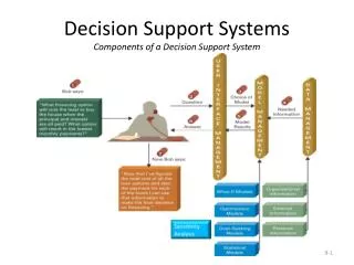
Tools • Part of modeling component of spatial decision support system • Based on geoprocessing tools from AGS • Each tool answers a specific question
Region Summary Tool • Summarizes data based on user-defined area • Example: employment occupational clusters for each county in US • The tool will sum employment for all counties that are selected by user interactively
Region Summary Tool - the model Prod Demo Tool Site Dev Demo Tool Site
Variable weighting tool • Overlays several maps into one based on weights assigned by user. • Can take vector and raster maps as inputs • All maps have equal weight by default (value of “1”) • Can use any weighting scale • verbal, e.g. “poor-excellent”, “low-high”; • Numeric, e.g. “-5 to +5”, “0 to 5” • These models can be theme specific (e.g. environmental only) or can combine data from different areas (e.g. economic, demographics, land use, etc.) • Useful when looking at different scenarios of development or prioritizing areas for development
Tips and tricks • Build model to answer a specific question: good decision support system should be intuitive and simple to use • Have detailed metadata or map description available for advanced GIS users • Keep models simple to improve processing time, preprocess maps if needed • Use relative paths when creating models in Model Builder • Get ArcSDE database well organized (naming, metadata) • Have metadata or description readily available for user to see along with the map • Easy to get data online
Future • What does a Regional Decision Maker look like? • How do the pieces we just preview fit in?
Moving forward • Decision trees • Develop more complex models to answer more complex questions. • a survey-style questionnaire that helps user answer specific questions regarding planning • For example, identify development strategies based on current environmental and economic characteristics of AOI and development preferences. The questionnaire can use “Yes-No” and/or multiple-choice format questions. • Can provide answer in a verbal and/or spatial (mapped) form
Conclusion • Adobe Flex API with ArcGIS Server • Presented data from research projects • Variety of ways for user to view and interface with data
Questions? • Thanks to … • PCRD • FNR • Sea Grant • Jarrod Doucette – Forestry and Natural Resources – jdoucett@purdue.edu • Indraneel Kumar – Purdue Center for Regional Development – ikumar@purdue.edu • Andrey Zhalnin – Forestry and Natural Resources – azhalnin@purdue.edu • Bryan Pijanowski – Forestry and Natural Resources • Angela Archer – Illinois-Indiana Sea Grant