Download
1 / 13
130 likes | 144 Views
Learn about USGS's oil spill monitoring efforts to detect, respond, and track spills in sensitive areas of Columbia River. Explore continuous WQ monitors and sensor technology for early detection and real-time data management.

E N D
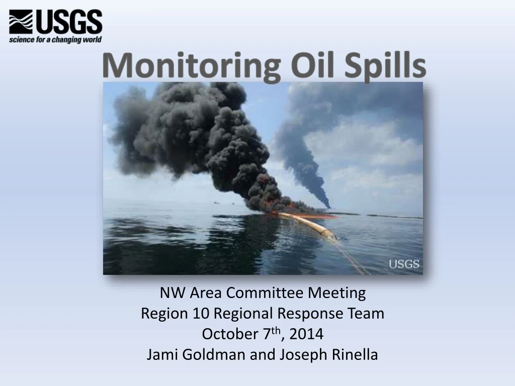
Monitoring Oil Spills NW Area Committee Meeting Region 10 Regional Response Team October 7th, 2014 Jami Goldman and Joseph Rinella
So why is USGS interested in Oil Spills? Work coincides closely with our Mission Areas Assessing Hazards to Ecosystems and Reducing Losses Identifying Environmental Risk to Public Health Assessingthe Quantity and Quality of Water formeeting future needs Understanding Ecosystems and Predicting Ecosystem Change
Columbia River Oil Monitoring • Need early detection of a spill event • Need to quickly respond to leaks and spill events (including nights, weekends, and holidays—i.e. 24/7) 3. Need a mobile sensor to track a spill event --Determine direction and time of travel -- Monitor in sensitive areas -- Identifyand predict the duration of time of the post spill events
5 4 3 2 Stream Velocity (feet/sec) 1 0 -1 -2 -3 Oct Dec Feb Apr Jun Aug Tue Sep 30 07:18:28 2014 Stream Velocity in Columbia River at Beaver Army Terminal, WY 2013
Estimate of oil plume 4 hours after spill at Beaver Army Terminal (RM 54) 12 miles down-stream after 4 hours at 4-5 ft/sec RM 42 5-6 miles upstream after 4 hours at -2 ft/sec RM 60 Down- stream Columbia River Beaver Army Terminal Spill Location RM 54
Columbia Reach Impacted by Spill Beaver Army Terminal PLUME PLUME
USGS Continuous WQ Monitors • USGS operates continuous WQ monitors across the country http://waterwatch.usgs.gov/wqwatch/ • USGS operates over 200 sites in Oregon (streamflow, temperature, pH, dissolved oxygen, specific conductance, turbidity, TDG, chlorophyll, blue-green algae, FDOM, and/or nitrate) • Follow strict USGS protocols • Provides continuous data for real-time management of water resources by our cooperating agencies. Columbia River at Bonneville Dam, photo U.S. Army Corps of Engineers
About 110 Continuous Temperature Monitors Water Temperature
Use of Continuous Oil Monitor Data • Early detection system • WaterAlert • Triggering emergency response and sample collection • Estimating concentrations of unmeasured constituents • Providing data for modeling plume movement • Assessing water quality • Detecting temporal variations • Increasing process-based knowledge of rivers Kalamazoo River Oil Spill, 2010, USGS photos
Oil Monitoring • Many hydrocarbon sensors are available (Wetlabs, ECO, AquaTracka, Turner Designs) • Dynamic range of detection limits, and wavelength configurations • Low detection limits ~300ppb • Sensor responses are linear over a range of concentrations • Sensors work well for tracking floating oil in the water column, (best for light crude oils—e.g. Bakken oil) Deepwater Horizon, USGS
Path Forward • Assess needs and funding for Columbia River -- Types of oils transported in the Region • Propose continued investigations • Confounding effects with interferences • Understanding behavior and fate of oil • Investigate coal contaminant tracking • Sensor data may be used for model development (for example, time of travel tracer studies for tracking plumes) • Complimentary/supplementary sensors • Particle size tracking • Hydroacoustics • Turbidity Columbia River, USGS photo
USGS Contacts James Crammond, Center Director 503-251-3204 Joe Rinella, Supervisory Hydrologist 503-251-3278 Stewart Rounds, Hydrologist/Water Quality Modeler 503-251-3280 Chauncey Anderson, Water Quality Specialist 503-251-3206 References Wagner, R., et al., Guidelines and Standard Procedures for Continuous Water-Quality Monitors: Station Operation, Record Computation, and Data Reporting, 2006. pubs.usgs.gov/tm2006/tm1D3/. Conmy, R. et al., Submersible Optical Sensors Exposed to Chemically Dispersed Crude Oil: Wave Tank Simulations for Improved Oil Spill Monitoring, 2014. ES&T, 48 (3), 1803-1810. Jami Goldman, Biologist Northwest Carbon Center, Project Coordinator http://or.water.usgs.gov/proj/carbon 503-251-3205 jgoldman@usgs.gov
SMART plan • Tier I: A trained observer, flying over the oil slick and using photographic job aids or advanced remote sensing instruments, assesses dispersant efficacy and reports back to the Unified Command. • Tier II: Tier II provides real-time data from the treated slick. A sampling team on a boat uses a monitoring instrument to continuously monitor for dispersed oil 1 meter under the dispersant-treated slick. The team records and conveys the data to the Scientific Support Team, which forwards it, with recommendations, to the Unified Command. Water samples are also taken for later analysis at a laboratory. • Tier III: By expanding the monitoring efforts in several ways, Tier III provides information on where the dispersed oil goes and what happens to it. • Two instruments are used on the same vessel to monitor at two water depths. • Monitoring is conducted in the center of the treated slick at several water depths, from 1 to 10 meters. • A portable water laboratory provides data on water temperature, pH, conductivity, dissolved oxygen, and turbidity. • In Situ Burning • For in situ burning operations, SMART recommends deploying one or more monitoring teams downwind of the burn, at sensitive locations such as population centers. The teams begin sampling before the burn begins to collect background data. After the burn starts, the teams continue sampling for particulate concentration trends, recording them both manually at fixed intervals and automatically in the data logger, and reporting to the Monitoring Group Supervisor if the level of concern is exceeded. The Scientific Support Team forwards the data, with recommendations, to the Unified Command.