Download
1 / 20
200 likes | 272 Views
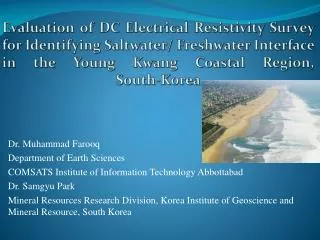
Evaluation of DC Electrical Resistivity Survey for Identifying Saltwater/ Freshwater Interface in the Young Kwang Coastal Region, South-Korea. Dr. Muhammad Farooq Department of Earth Sciences COMSATS Institute of Information Technology Abbottabad Dr. Samgyu Park

E N D
Evaluation of DC Electrical Resistivity Survey for Identifying Saltwater/ Freshwater Interface in the Young Kwang Coastal Region, South-Korea Dr. Muhammad Farooq Department of Earth Sciences COMSATS Institute of Information Technology Abbottabad Dr. Samgyu Park Mineral Resources Research Division, Korea Institute of Geoscience and Mineral Resource, South Korea
Quran & Water • Soorat al-Furqaan 25:53 • And he has set free the two seas; one is fresh and palatable and the other is salty and bitter; and he has built between them a formidable, inviolable barrier. • Sooratar-Rahman 55:19-20 • He let free the two seas, they meet together; he has built a barrier between them, they do not transgress
Geography of South Korea • Located in East Asia • Land border with North Korea • Coast line along three seas: 2413 kms • Land mass is approx= 100,032 sq kms Geology of South Korea • Most rocks are of Precambrian age • Isolated Pockets of Paleozoic, Mesozoic • & Cenozoic • Baekdu & Hallasan mountain have • crater lakes • Hot springs indicate volcanic activity are widespread throughout Peninsula
Topography & Drainage • Tallest mountain is Hallasan (1950 m) • Volcanic formation constituting • Jeju Island • Geologially stable • (no active volcanoes & Earth quake) • Aprrox. 30 % of the area consists • of lowlands • Aprrox. 70 % of the area consists • of uplands / mountains • Three important river, Nakdong • (521 kms), Han river (514 kms) and • Geum river (401 kms)
Saltwater Intrusion • The movement of saline (salty) water into a freshwater aquifer • If source is marine water, the process is known as Seawater Intrusion • primary mechanisms of saltwater intrusion • Subsurface seawater movement (lateral large scale intrusion) • Seepage from tidal canals and streams • Connate upward movement from lower formations • (well withdrawals)
Factors controlling the extent of Salt Intrusion • Rate of withdrawal vs. freshwater recharge • Distance of stress from saltwater source • Geologic structure So, why is this a problem? • Saltwater unfit for human consumption, other anthropogenic uses • Reduces fresh groundwater storage • Abandonment of supply wells • Coastal ecosystems sensitive to salinity changes • Red tides, fish kills, loss of sea grass habitat, destruction of coral reef
Electrical Resistivity (ER) • Electrical Current is induced into the ground through two current electrodes. • Voltage drop is measured across potential electrodes. • Electrode array is expanded to increase depth of penetration. • Resistivity of formation/fluids measured in ohm-meters (Ω-m). • Modern systems use multi electrodes with automated switching.
Vertical Electrical Sounding Data Acquisition layout VES 10 A` VES 11 VES 9 BH-02 VES 8 VES 5 VES 4 VES 7 VES 6 BH-01 A VES 3 VES 1 VES 2 0 2 Km
Curve Matching Technique in Vertical Electrical Sounding VES 5 VES 6 VES 7 VES 8 VES 9 VES 11
Litho- Resistivity Stratigraphic Cross Section VES 10 A` VES 11 VES 9 VES 8 BH-02 VES 5 VES 4 VES 7 BH-01 A VES 6 VES 3 Brackish water Brine water VES 1 VES 2 0 2 Km
Conclusions • Saline water intrusion has been taken place • Depth of intrusion increased as moved toward coastal area. • It is important to monitor sea water intrusion with the help of geophysical technique • Geophysical technique helps us to minimize the cost and understand problem in better way Recommendations • Regulatory (legislative) approaches • Scientific monitoring/assessment
Thank You! Question????????