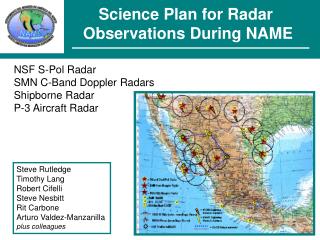
Science Plan for Radar Observations During NAME
140 likes | 312 Views
Science Plan for Radar Observations During NAME. NSF S-Pol Radar SMN C-Band Doppler Radars Shipborne Radar P-3 Aircraft Radar. Steve Rutledge Timothy Lang Robert Cifelli Steve Nesbitt Rit Carbone Arturo Valdez-Manzanilla plus colleagues. Basic Science Objectives of Radar Observations.

Science Plan for Radar Observations During NAME
E N D
Presentation Transcript
Science Plan for Radar Observations During NAME NSF S-Pol Radar SMN C-Band Doppler Radars Shipborne Radar P-3 Aircraft Radar Steve Rutledge Timothy Lang Robert Cifelli Steve Nesbitt Rit Carbone Arturo Valdez-Manzanilla plus colleagues
Basic Science Objectives of Radar Observations • Document horizontal distribution of rainfall amount and intensity • Document storm morphology • Document the diurnal cycle of rainfall and convection • Identify 2-D airflow features such as gust fronts, sea breezes, etc. • Hydrometeor identification to aid verification of models Science Questions Addressed by Radar Network • What are the (thermo)dynamical and microphysical characteristics of convection? • What is the diurnal behavior of convection within the monsoon regime? • What are the physical processes controlling the diurnal cycle over land and ocean? • How well do models simulate convection in complex terrain? • What is the connection between synoptic variability and Gulf surges? • What are the characteristics of Gulf surges? • What are the links between monsoon strength and precipitation over the central US?
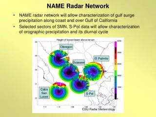
Platform Descriptions • NCAR/NSF S-Pol Radar • S-Band, Dual-Linearly Polarized, Doppler • Provides superior rain estimates to conventional radars • Can distinguish between hydrometeor types • SMN C-Band Doppler Radars • Four locations extend coverage region over much of Tier I • Run remotely, data saved via planned digitization upgrades • S-Pol radar, gauges can be used to help improve rain estimates • Provide important data to address storm structure, climatology, hydrological applications
Platform Descriptions • Shipborne C-Band Doppler Radar • Radar unlikely to be deployed due to lack of radar-capable ship • Puma ship can be used for sounding, flux, and profiler measurements in the mouth of the GoC • Aircraft X-Band Doppler Radar • On NOAA P-3; Obtain additional flight hours if no ship radar • Dual-Doppler coverage, in situ microphysical measurements • No 24-hour coverage; Event-based flights over GoC, elsewhere
Measurement Protocols • S-Pol Radar • 24-hour/day ops for 6 weeks • 15-minute cycle w/ 360° vol, PPI, and RHI sectors • Staffed by NCAR and CSU • SMN Radars • 24-hour/15-minute cycle matched w/ S-Pol • Pre-programmed 360° volumes w/ 7.5-min period • Elevation angles, etc., unique to each site (blockage,etc.) • Oversight by Arturo Valdez-Manzanilla & NCAR • Shipborne Radar • Unlikely to be available; Would be continuous 360° vol • Staffed by CSU, others • Still place Puma and launch 6 soundings/day for ~42 days on station (three 14-day IOPs); Continuous profiler & flux
Measurement Protocols • Aircraft Radar • Add ~60 flight hours (7-8 research flights) to the NOAA P-3 to provide radar coverage of convective systems over the GoC and SMO • Collect dual-Doppler (and in situ microphysical data) in these systems • Non-continuous coverage • CSU personnel oversee in-flight radar data acquisition
Possible Flight Patterns for P-3 Track evolving MCSs as they move into Gulf from SMO Or track already developed GoC systems
Data Dissemination Data will be disseminated in a delayed fashion due to high QC requirements of radar data Raw data can be provided in standard DORADE/UF formats quickly; Same with aircraft or shipborne radar data Radar data will require extensive QC due to anticipated blockage, clutter, and attenuation Individual radar data is not anticipated to be the most useful format to most NAME users Therefore, combine QC’d S-Pol, SMN, and other radar data into a merged, regional product - CSU student under NCAR supervision
Details of Merged Radar Product NAME objectives focus on regional-scale processes, therefore a regional-scale radar product is required Create regional composites of rainfall maps and gridded volumes of convective echo; Include time-cumulative, averaged, and time-progressive composites Available at intervals of 15-minutes or less; Nested, telescoping grids Created after QC through NCAR gridding and analysis software; Anticipated format would be NetCDF or variant thereof Input from other NAME PIs will be used to determine gridding and filtering options (e.g., grid spacing) that best meet NAME objectives
Example Data Product 24-hour rainfall accumulation from gridded hourly NEXRAD Level-II low-elevation data, 27 May 1998
Other Radar Products Gridded S-Pol hydrometeor identification, for model verification; Available for most radar volumes In addition, S-Pol & gauges will be used to help correct attenuation and to improve Z-R estimates from SMN and other radars Kinematic analyses of selected events (from P-3) Rain rate/accumulation product over radar-covered, gauged watersheds Anticipate quick delivery of raw data (DORADE, UF) for individual radars, but creation of regional composites, and other processed analyses could take 12+ months for full datasets Can fast-track high-priority cases!
Field Coordination Requirements S-Pol will be base of radar observations - extensive coordination will be required with aircraft, in order to provide flight guidance and target selection during radar-oriented flights Radar scientists will need to be involved in determination of radar-oriented P-3 flights if they are made available; CSU will provide staff for those flights SMN radars cannot be adjusted for individual events; Scan strategy will be set prior to project S-Pol will adjust PPI and RHI sectors depending on evolving situation; However, there will be 360° volumes available every 15-min for rain maps, etc.
Coordination with Other NAME Researchers We anticipate extensive contact and collaboration with NAME data assimilation and modeling researchers Coordinate the QC and processing of radar data to create the merged regional, microphysical, and kinematic products that meet NAME science objectives and researcher requirements Collaborate with the NAME hydrological community through radar/gauge comparisons, rain maps