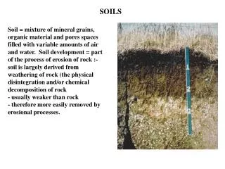
Enhancing Soil Data for Effective Modeling: Insights from NRCS NASIS and Soil Taxonomy
The National Soil Information System (NASIS) provides critical soil data that predates modern computing, compiling decades of information. While not specifically designed for advanced modeling purposes, this data can be adapted to meet contemporary modeling needs, addressing its inherent errors and omissions. Characterization data supports soil classification and land use decision-making, while NRCS databases offer a representative value for empirical model applications. Recent efforts focus on improving data collection, including dynamic soil properties, to enhance usability in agricultural and environmental modeling.

Enhancing Soil Data for Effective Modeling: Insights from NRCS NASIS and Soil Taxonomy
E N D
Presentation Transcript
NRCS Soils Data National Soil Information System NASIS
NRCS Soil Data • Origins pre-date computers and models • data collection spans decades. • Not designed or maintained with modeling in mind. • Not perfect; need to have a procedure to handle errors and omissions. • Must be adapted to meet model needs
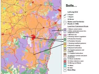
Characterization Data 70+ years Support classification and Soil Taxonomy Support interpretations Point data, measured Horizons NASIS ~20 years, early computer tech Interpret char. data Provides interp. data for broad landuse decisions Mapunit based, not pt. Layers NRCS Soil Databases
NRCS Soil Databases • Both NASIS and Soil Taxonomy are landuse independent. • Characterization data may provide clues. • Use Soil Taxonomy to fill or fix bad records.
NRCS Soil Databases • NASIS reports a Representative Value (RV) and a range, hi and lo. • Use the value that best reflects the landuse being modeled. • The RV works better for empirical models like RUSLE than a process model like EPIC or APEX
Ap Layer 1 AB Bt1 Layer 2 Bt2 2Bt3 Layer 3 2Bt4
Updates for modeling • Established research grade position for modeling support for Soil Survey. • Rapid C project. Collecting soil carbon data at NRI points. • Error and omission checking. • Begin collection of dynamic soil propeprties and data structure for dissemination.