Download
1 / 1
10 likes | 220 Views
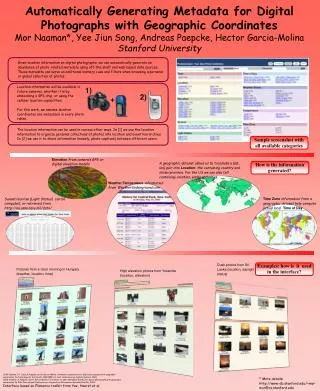
1). 2). +. Elevation from camera’s GPS or digital elevation models. Automatically Generating Metadata for Digital Photographs with Geographic Coordinates Mor Naaman*, Yee Jiun Song, Andreas Paepcke, Hector Garcia-Molina Stanford University.

E N D
1) 2) + Elevation from camera’s GPS or digital elevation models Automatically Generating Metadata for Digital Photographs with Geographic Coordinates Mor Naaman*, Yee Jiun Song, Andreas Paepcke, Hector Garcia-Molina Stanford University Given location information on digital photographs, we can automatically generate an abundance of photo-related metadata using off-the-shelf and web-based data sources. These metadata can serve as additional memory cues and filters when browsing a personal or global collection of photos. Location information will be available in future cameras, whether it is by embedding a GPS chip, or using the cellular location capabilities. For this work, we assume location coordinates are embedded in every photo taken. The location information can be used in various other ways. In [1] we use the location information to organize personal collections of photos into location and event hierarchies. In [2] we use it to share information (namely, photo captions) between different users. Sample screenshot with all available categories A geographic dataset allows us to translate a (lat, lon) pair into Location: the containing country and state/province. For the US we can also tell containing counties, parks and cities. How is the information generated? Weather/Temperature information from WeatherUnderground.com Time Zone information from a geographic dataset help compute actual local Time of Day Sunset/sunrise (Light Status) can be computed, or retrieved from http://aa.usno.navy.mil/data/ Dusk photos from Sri Lanka (location, daylight status) Examples: how is it used in the interface? Pictures from a clear morning in Hungary (weather, location, time) High elevation photos from Yosemite (location, elevation) [1] M. Naaman, Y.J. Song, A.Paepcke, and H. Garcia-Molina. Automatic organization for digital photographs with geographic coordinates. In Proceedings of the Fourth ACM/IEEE-CS Joint Conference on Digital Libraries, 2004. [2] M. Naaman, A. Paepcke, and H. Garcia-Molina. From where to what: Metadata sharing for digital photographs with geographic coordinates. In 10th International Conference on Cooperative Information Systems (CoopIS), 2003. Interface based on Flamenco toolkit from Yee, Hearst et al. * More details: http://www-db.stanford.edu/~mor mor@cs.stanford.edu