
Fort Means
E N D
Presentation Transcript
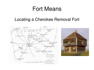
Fort Means Locating a Cherokee Removal Fort
John Means of Walton County was ordered in April, 1838 to “establish a post ‘in Floyd County, Georgia near the dividing line between it and Cass County and also near the Hightower [Etowah] River.’”--Dr. Sarah Hill in her draft report Cherokee Removal: Forts Along the Georgia Trail of Tears
Fort Means • 467 Cherokee prisoners • Hastily constructed – meant to be temporary • Rather large -- Included stables, living quarters, ammunition depot, etc.
The Fort Means Letter • Written in May 1838 from Fort Means, Floyd County.
The Mabry Proposal • Fort Means located somewhere in District 23, Section 3, Land Lot 264, on a lot owned in 1838 by trader and Major Ridge associate George Lavender.
From the Mabry Report: • “The knoll in lot 264 is ... the ideal location in relation to the river and ferry crossing, the Alabama/Kingston Road, the direct link to the Rome/New Echota Trail, as well as having an abundance of water on an elevated spot. The George Lavender ownership only adds to the interest of lot 264, because he operated a large freight ... business and would have wanted the fort supply contracts.” – Doug Mabry
Putman • I read this as: “on Mr Putnam’s plantation 1 ½ Miles South of this place & on the west Side of Hightower or utiwah River 8 Cabbins ____ No of Ind 50 Indian”
Land Transactions • William Boyd to Jacob Putman; 23, 2, LL 338 (160 acres); indenture made Feb. 15, 1836; recorded Mar. 26, 1837 (C/30) • James Liddell to Jacob Putman; 23, 3, LL 299; (C/30) indenture made Jan. 10, 1837; recorded Mar. 26, 1837 (C/30) • John A. Jennings to Jacob Putman; 23, 3, LL 303; indenture made Mar. 25, 1837; recorded Mar. 25, 1837 (C/28) • Jno. H. Lumpkin to Jacob Putman; 23, 3, LL 301 (160 acres); indenture made Dec. 5, 1837; rec. April 6, 1838 (C/240) • Jacob Putman to William T. Price; 23, 3, LL 303 (160 acres); indenture made Mar. 10, 1838; rec. Mar. 12, 1838; (C/195) • Jacob Putman to William T. Price; 23, 3, LL 338 (160 acres); Mar. 12, 1838; indenture made Mar. 10, 1838; rec. Mar. 12, 1838 (C/195) • Jacob Putman to James McConnell; 23, 3, LL 301, 299, 302; indenture made Jan. 1, 1848; rec. April 4, 1848 (E/470) • Thomas M. Jones to Jacob Putman; 23, 3, LL 302 (160 acres); indenture made Feb. 1838; rec. April 19, 1849 (F/201) • Jacob Putman to James McConnell; 23, 3, LL 299 (160 acres); indenture made April 4, 1849; rec. April 19, 1849 (F/202)
Williams • I read this as: “at Mr Williams 2 ½ Miles South on S Side R: 4 Cabbins __ 30 Ind”
Mann • I read this as: “Mr. Manns 3 ½ M Same Side R South __ 2 Cabbins ___ 12”
Land Transactions • Hiram T. Mann to William T. Price; 23, 3, 341 (160 acres); indenture made Nov. 30, 1836; rec. April 16, 1838 (C/238) • Nathaniel Harris to Joel Mann; 23, 3, LL 290; indenture made Dec. 19, 1836; rec. June, 1838 (C/315) • Bennett Lawrence to Joel Mann; 23, 3, 311 (160 acres); indenture made July 3, 1837; rec. Dec. 22, 1838 (C/447) • Joel Mann to Robert Mitchell; 23, 3, LL 290 and 311; indenture made Dec. 6, 1838; rec. Dec. 22, 1838 (C/448)
Lampkin I read this as: • “Mr Lampkins on the E.Side R 5 Miles South 9 Cabbins __ _ 15”
Land Transactions • Nancy Yancey to Geo. W.F. Lampkin; 23, 3, LL 285 (160 acres); indenture made Nov. 29, 1832; rec. Jan. 23, 1833 (A/97-100) • William B. Curtis to Lewis A.L. Lamkin; 23, 3, LL 235 (160 acres); indenture made Nov. 1, 1834; rec. April 1835 (A/465) • H.G. MacFarland to Lewis A.L. Lampkin; 23, 3, LL 334 (160 acres); indenture made Nov. 22, 1834; rec. April 18 (A/463) • Tomlinson Fort, Zachariah Hargrove, John Martin, William Solomon et al by attny. to Lewis A.L. Lampkin; 23, 3, 336 (160 acres); indenture made April 14, 1835; rec. April 18, 1835 (A/466 and 467) • William T. Price to Lewis A. Lamkin; 23, 3, 26 acres of LL 337; indenture made Mar. 10, 1838; rec. Mar. 12, 1838 (C/194) • Lewis A.L. Lamkin to Benjamin Reynolds; 23, 3, LL 337, 335, 336 (192 acres); indenture made Aug. 17, 1844; rec. Apr. 6, 1847 (E/327) • Lewis A. L. Lampkin to the Memphis Branch of RR and Steamboat Co. of Georgia (right of way) on 23, 3, LL 306 and 307; rec. Nov. 9, 1849 (F/395) • (Lewis A.L. Lampkin’s contiguous lots 23, 3, LL 306, 307, 334, and 335 were not sold until his apparent death on Jan. 17, 1851, indicating that his residence was possibly included on one of these lots.)
Price I read this as: • “Mr Price plantation 3 M E Side R. 3 Cabbins 25”
Land Transactions • Hiram T. Mann to William T. Price; 23, 3, LL 341 (160 acres); indenture made Nov. 30, 1836; rec. April 16, 1838 (C/238) • Wiley A. Thomas to William T. Price; 23, 3, LL 339; indneture made Jan. 18, 1837; rec. Jan. 25, 1837 (B/612) • Allen Dyke to William T. Price; 23, 3, LL 337; indenture made April 1837; rec. May 26, 1837 (C/29) • William T. Price to Abram Fain; 23, 3, LL 339; indenture made Sept. 28, 1837; rec. Nov. 27, 1837 (C/126) • William T. Price to Lewis A.L. Lamkin; 23, 3, part of LL 337 (26 acres); indenture made Mar. 10, 1838; rec. Mar. 12, 1838 (C/194) • Jacob Putman to William T. Price; 23, 3, LL 338 (160 acres); indenture made Mar. 10, 1838; rec. Mar. 12, 1838 (C/195) • Jacob Putman to William T. Price; 23, 3, LL 303 (160 acres); indenture made Mar. 10, 1838; rec. Mar. 12, 1838 (C/195) • D.R. Mitchell to William T. Price; 23, 3, 304 (160 acres); indenture made Sept. 4, 1838; rec. Sept. 6, 1838 (C/380) • William T. Price to Joseph T. Price; 23, 3, LL 298, 303; indenture made Aug. 5, 1839; rec. Jun. 10, 1840 (D/26). • William T. Price to Joseph T. Price; 23, 3, 304 (150 acres); rec. Jun. 10, 1840 (D/26) • William T. Price to Nathan Bass; 23, 3, LL 338, 341, 337, 303, 304; 22, 3, LL 324; rec. Jan. 17, 1846 (E/133) • William T. Price to Memphis Branch of the RR and Steamboat Co. of GA (arbitrator); right-of-way for 23, 3, LL 303 and 304; rec. Nov. 8, 1849 (F/394)
Fain I read this as: • “Mr Fain’s do 4 Cabbins 2 M E side Utiwah R. 30”
Land Transactions • William T. Price to Abram Fain; 23, 3, LL 339; indenture made Sept. 28, 1837; rec. Nov. 27, 1837 (C/126)
Major Wooley I read this as: “Major Woolys platn. 9 Cabbins 4 M E & E Side R. Utiwa or Hightower 90”
Land Transactions • James R. Cox to A.F. Wooley; 16, 3, 245; indenture made Jun. 20, 1836; rec. Oct. 18, 1847 (C/100). • William Jones to A.F. Wooley; 16, 3, 249 (160 acres); indenture made Apr. 18, 1837; rec. Mar. 5, 1838 (C/232) • Roger McCarthy to Andrew F. Wooley; 16, 3, 218 (160 acres); indenture made Aug. 15, 1837; rec. Mar. 5, 1838 (C/231) • Lee R. Miller to Andrew F. Wooley; 16, 3, LL 235; indenture made Nov. 20, 1846; rec. Dec. 16, 1846 (G/359). • A.F. Wooley to Allen A. Williams; 16, 3, 244 (a portion); indenture made Feb. 28, 1847 (I/176) • A.F. Wooley to Benjamin Reynolds; 16, 3, 238; indenture made Dec. 25, 1847 (I/464). • A.F. Wooley to Rufus M. White; 16, 3, 158; indenture made Dec. 20, 1848 (I/404)
Miller I read this as: • “Genl Millers plt. 1 Mile E Side R. 9 Cabbins 90 2 Miles E of E Side R. 2 Cabbins 15”
I read this as: • “J Millers 1 M N.E. 2 Cabins 6”
Land Transactions • Andrew Miller • Sheriff Wofford to Andrew Miller; 16, 3, LL 213; purchased Dec. 5, 1837; indenture made Dec. 6, 1837; rec. Jan. 10, 1838; (C/164) • Homer V. M. Miller • Burrell White to H.V.M. Miller; 16, 3, LL 268 (160 acres); indenture made Mar. 3, 1838; rec. July 14, 1838 (C/400) • H. V. M. Miller to George W. Underwood; 16, 3, LL 55; indenture made July 6, 1841; rec. Sept. 27, 1888 (AA/60) • Homer V. M. Miller to Thomas M. Berrien; 16, 3, LL 177; indenture made Oct. 2, 1846; rec. Sept. 14, 1847 (H/79) • Homer V. M. Miller to John P. Eve; 16, 3, LLs 181, 182, 209, 210, 211, 212, 213, 240 (1300 acres); indenture made May 17, 1861 (M/535) • H. V. M. Miller to Jane Park; 16, 3, LL 268; indenture made Dec. 5, 1879; rec. Sept. 11, 1880 (V/503) • John C. Miller / Homer V. M. Miller • John C. Miller (by Sheriff Joseph Boyle’s sale) to Homer V. M, Miller; 16, 3, LL 95; indenture made July 6, 1840; rec. Oct. 9, 1841 (AA/59) • Lee Miller • John F. and Alexander Kennedy to Lee R. Miller; Oct. 1836; (16, 3, LL 235?); indenture made Oct. 17, 1838; rec. Dec. 16, 1846 (G/358). • Lee R. Miller to Andrew F. Wooley; 16, 3, LL 235; indenture made Nov. 20, 1846; rec. Dec. 16, 1846 (G/359).
Other reference points The Means Letter contains a number of other reference points, which I shall briefly outline: • Judge Underwoods E Side R. Utiwah or Hightower 8 Cabbins _____ 75 • Geo Underwood 9 Mile E & E Side Utiwa or Hight R 2 Cabbins 10 • W Burges 10 Miles E of Utw or Hight R. E Side 1 Cabbin • do do on W Side at Camp 2 in a Cabbin • 11 M. SE on the Newharly Cr 2ns Cabbin Shutdoor 50 • (pg. 2) • Conicene 4 Miles E & W Side Utiw or No Indian • Hightower R 2 Cabbins No Ind 15 • Col. Waters plt. on Oostanalee R 8 Miles N.W. 2 Cabbins 15 • Lavinders 10 M N.W. 2 Cabbins 15 • Col. Hardins 9 M 5 Cabbins 30 • These reference points are good for nailing down the general area for Fort Means (somewhere between Rome and Kingston, roughly along the original Etowah Road), but are not precise enough to put Fort Means into a specific land lot.
Comparisons Reviewing some of the distances in the 1838 Means Letter, from closest to farthest away: • G. Miller 1 mile • Putman/Putnam, 1 ½ m S • Fain, 2 m • Price 3 m • Mann 3 ½ m S • Wooly/Wooley 4 m E • Conicene 4 Miles E • Lampkin 5 m S.
The Mabry Proposal Reviewing some of the distances in the 1838 Means Letter, from closest to farthest away: • G. Miller 1 mile • Putman/Putnam, 1 ½ m S • Fain, 2 m • Price 3 m • Mann 3 ½ m S • Wooly/Wooley 4 m E • Conicene 4 Miles E • Lampkin 5 m S.
Reviewing some of the distances in the 1838 Means Letter, from closest to farthest away: • G. Miller 1 mile • Putman/Putnam, 1 ½ m S • Fain, 2 m • Price 3 m • Mann 3 ½ m S • Wooly/Wooley 4 m E • Conicene 4 Miles E • Lampkin 5 m S.
The Orders: John Means of Walton County was ordered in April, 1838 to “establish a post ‘in Floyd County, Georgia near the dividing line between it and Cass County and also near the Hightower [Etowah] River.’” --Dr. Sarah Hill in her draft report Cherokee Removal: Forts Along the Georgia Trail of Tears
Reviewing some of the distances in the 1838 Means Letter, from closest to farthest away: • General Miller 1 mile • Putman/Putnam, 1 ½ m S • Fain, 2 m • Price 3 m • Mann 3 ½ m S • Wooly/Wooley 4 m E • Conicene 4 Miles E • Lampkin 5 m S.
The Transaction: • Homer V. M. Miller to John P. Eve; 16, 3, LLs 181, 182, 209, 210, 211, 212, 213, 240 (1300 acres); indenture made May 17, 1861 (M/535)
Reviewing some of the distances in the 1838 Means Letter, from closest to farthest away (Mann and Williams omitted): • General Andrew Miller 1 mile (precise) • J. Miller, 1 mile NE (probably John C. Miller, son of Andrew Miller; postulated that HVM Miller obtained lot or inherited it from John, his brother, prior to 1847.) • Putman/Putnam, 1 ½ m S (precise) • Fain, 2 m (precise) • Price 3 m (precise if going west on Etowah Road, then due south to Price) • Wooly/Wooley 4 m E (Postulate: the lot referred to is on the Conesena -- precise) • Conicene 4 Miles E (precise) • Lampkin 5 m S.(precise if going west on Etowah Road, then due south to Lampkin)
From an Internet genealogical source: • The original millers came from Ireland Because of religious beliefs. There were three brothers -- John, Andrew, and James. They landed in Pennsylvania but the time is not remembered. They migrated to South Carolina, Virginia, and one brothers destination was not certain. We are the descendants of John Miller, who went to South Carolina. He was the father of General Andrew Miller, who was born in Abbeville District, S.C.. Later he moved to Georgia and married a Mrs. Crawford, whose maiden name was Miss Cherry. She was a Huguenot, who came from France because of the persecutions of the Huguenots. General Andrew Miller was General of the Georgia Militia and fought in the war of 1812. There is a bill of sale for "Old Grant" to grandma and grandpa Cherry which was written by Mr. Crawford. "Old Grant" was little Andrew's bodyguard.To this union was born:*1. John C. Miller, who was our grandfather2. Dr. Andrew J.S. Miller, He was killed in Waco, Texas3. Dr. H.V.M. Miller, who was Dean of the Atlanta Medical College for 15 years4. Mary I. Miller, who was our grandmother
Postulate: Fort Means was located at extreme west of Lot 16, 3, 210, straddling Cedar Creek; possibly crossing over into lot 23, 3, 261 to the immediate west; right at the old Cass/Floyd border (Note the flat, green, open area near the center of the next slide, where the two branches of the stream converge just north of the Etowah River. This would have been between the original Etowah Road and the Etowah River, as shown above. The Etowah Road has been realigned to the north –[compare 1895 map at right to 1832 above].)