Download
1 / 24
240 likes | 270 Views
Explore the collaborative efforts of NOOS partners in operational oceanography for the European NW Shelf. Discover how NOOS strategically produces and shares ocean monitoring and forecasting services, leveraging advanced technologies like in-situ sensors, smart buoys, and remote sensing for environmental assessments.

E N D
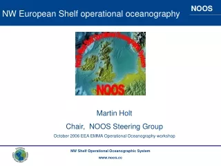
NW European Shelf operational oceanography Martin Holt Chair, NOOS Steering Group October 2006 EEA EMMA Operational Oceanography workshop
This talk • What is NOOS • Foundations for • Monitoring • Modelling • Remote sensing • An existing product for Environmental Assessment • Summary
NOOS: Strategic principles Efficient shared production of ocean monitoring and forecasting services for the European NW Shelf NOOS MOU 19 Partners: organisations engaged in national operational oceanographic services Representing: Norway, Sweden, Denmark, Germany, Netherlands, Belgium, UK, Ireland and France All the NW Shelf coastlines NOOS has no money for doing NOOS Business Only in each agency for the national work
NOOS activities 2002 onwards 2002 2003 2004 2005 2006 2007 2008.. Storm surge forecast exchange Started 1999 EGS paper RIKZ “MATROOS” Water level exchange ftp boxNorth Sea map complete Model transports exchange Contribution to ICES-EuroGOOS North Sea pilot project ftp box waves ftp box T, S SEANET NOOS FerryboxNOOS
NOOS monitoring foundations Insitu: from national monitoring networks. See SEPRISE, EDIOS Ferrybox: eg GKSS, NIVA, transition from research to operations Smart buoy: national network: physical, nutrient and DO Continuous Plankton Recorder “EMECO” a European Marine Ecosystem Observatory
(from SEPRISE) Operational Observing NetworkWaves real-time stations
FERRYBOX: NIVA’s Operational Ferrybox Observation System • MS Trollfjord: Bergen–Kirkenes (every five days) • Color Festival: Oslo–Hirtshals (twice a day) • Fjord Norway: Bergen-Newcastle (twice a week) Bergen-Hanstholm (once a week) • Kronprins Harald: Oslo-Kiel www.ferrybox.no
Biogeochemical: eg Cefas Smart buoy and SAHFOS Continuous Plankton Recorder tracks www.cefas.co.uk www.sahfos.org
NOOS modelling foundations • 3D Coupled physical-ecosystem modelling, shelfwide • Nested into MERSEA Atlantic open ocean models, Baltic boundary data • Surface forcing typically from high-resolution (~12km) Met models • Regional coastal models (national) • Extensive validation against in-situ and remote sensing • Strong scientific programme of development A validated modelling system can be used for long hindcast (recent climate), today’s operational forecast, and also future climate change impact studies • Some Agencies are preparing nowcast-forecast application (a contribution to harmful or nuisance blooms warning for Bathing Waters directive), other applications are hindcasts for scenario / OSPAR / ICES / process studies • NEEDED for nrt: near-real-time river flow and nutrient loading data
NOOS 3D coupled physical-ecosystem modelling examples UK: polcoms-ersem MRCS IMR, met.no Norwecom MUMM: Miro&Co3D
Shelfwide “nowcast”: MRCS polcoms-ersemUK National Centre for Ocean Forecasting www.ncof.gov.uk Total surface chlorophyll` Last week (14 Oct 2006) Hindcast completed for 2002-2005. Nowcast continues with weekly update. Daily update from November 2006 Display on Met Office web pages at http://www.metoffice.gov.uk/research/ncof/mrcs/browser.html Chlorophyll: section along 2E Last week (14 Oct 2006)
CPR tows reconstructed from the model;comparison of daily mean normalised data. Use of CPR network for model hindcast assessment 1988-89 Lewis, Allen et al 2006, JMS Compare: Phytoplankton Diatoms Flagellates/PCI Copepods
Near real time validation WEEKLY COMPOSITE satellite and model Chlhttp://www.npm.ac.uk/rsg/projects/mceis/
NOOS ocean remote sensing foundations SST, Sea Ice: EUMETSAT OSI SAF; GHRSST and OSTIA Ocean Colour: regional / national processing centres; PML, MUMM, ACRI Marcoast Chl and Inherent Optical Properties
Ocean Colour Remote sensing www.pml.ac.uk Inherent Optical Property Modelling • Historically ocean colour data is used to empirically derive sea-surface chlorophyll, however these empirical algorithms are fraught with difficulties • A better approach is to determine the absorption and backscatter directly from the primary observable (reflectance) • This can give better parameters for assimilation into e.g. ecosystem models and for getting a handle on phytoplankton functional types. Products • Total absorption at 443nm (a_443) • Absorption due to phytoplankton a_ph • Absorption due to detrital and yellow substance (CDOM) • Backscatter due to particulates (bp_551)
Remote sensing www.pml.ac.uk Modis aqua 9 October 2006 a_443 bp_551 Total absorption particulate absorption
The ICES-EuroGOOS North Sea Pilot Project NORSEPP NW shelf climate status assessment for fisheries
ICES-NOOS North Sea pilot project NW shelf climate status assessment for fisheries Planning group initiated in 2002 Quarterly or 6-monthly summary on ICES website since 2005 Q1: www.ices.dk BSH IMR MetO MUMM contributions Modelled and observed monthly mean temperature, salinity and currents data Modelled transports Recently added: IBTS and fishery cruise observations More model-obs temperature comparison Satellite and modelled Chl
Transport into North Sea NOOS NORSEPP contribution from MUMM
Indicators example: NORSEPP modelled monthly mean near-bed temperature to Q3 2006 Difference from WOA climatology
From NORSEPP 2006Q2 Comparison of model with Q1 IBTS cruise data Figure C Colocations of 2006 Q1 IBTS observations for temperature and salinity with MRCS model (POLCOMS V5 configuration) Measured Jan-Feb Available for co-location by mid-May
Summary Validated models can provide 4D information on: • Sea temperature • Currents • Salinity • Phytoplankton biomass, primary productivity, zooplankton biomass (seasonal and spatial) • Interannual, seasonal and spatial variability of background state for nutrients, for DO • ….
Summary • NOOS coordinates the national foundations for operational oceanography on the NW Shelf • NOOS members are ready to contribute to pilot projects for environmental assessment of the NW Shelf
![The European North Atlantic shelf [Ocean-Shelf Exchange, internal waves]](https://cdn0.slideserve.com/118374/the-european-north-atlantic-shelf-ocean-shelf-exchange-internal-waves-dt.jpg)