Download
1 / 5
50 likes | 80 Views
U.S. NAVY RIGHT WHALE PROTECTIVE MEASURES. BRIEFING TO THE NORTHEAST IMPLEMENTATION TEAM 5 APRIL 05. Tom Fetherston Navy Representative NEIT. Section 7 Consultation with NOAA concluded in 1997 Annual message prior to calving season 1 Dec – 30 Mar Ordnance use limited

E N D
U.S. NAVY RIGHT WHALE PROTECTIVE MEASURES BRIEFING TO THE NORTHEAST IMPLEMENTATION TEAM 5 APRIL 05 Tom Fetherston Navy Representative NEIT
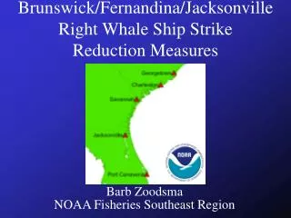
Section 7 Consultation with NOAA concluded in 1997 Annual message prior to calving season 1 Dec – 30 Mar Ordnance use limited Limit east-west transiting through critical habitat and area of concern where practical. Vessel speed limitations in critical habitat and area of concern. "use extreme caution and use slow safe speed, that is, the slowest speed that is consistent with essential mission, training and operations. Operations in critical habitat and area of concern limited to daylight and periods of good visibility, to the extent practicable and consistent with mission, training and operation. Two lookouts; one Marine Mammal Lookout (trained) required when operating in critical habitat and area of concern. Early Warning System (EWS) Communication and reporting network coordinated through Fleet Area Control and Surveillance Facility (FACSFAC) Distributes right whale sighting information to DoD and civilian shipping Navy also contributes funding for EWS survey flights Right Whale Protective MeasuresSoutheast
Right Whale Protective MeasuresNortheast • Fleet message in June 2002 • Ships transiting Great South Channel and Cape Cod Bay Critical Habitats check into MRS for latest sighting data • Ships approaching these areas or areas of high concentration “shall use extreme caution and operate at a safe speed” • Additional speed reductions required when whale is sighted or within 5 nmi of a reported location less than one week old • Lookout requirements same as Southeast: Two lookouts; one Marine Mammal Lookout (trained) required when operating in critical habitat and area of concern.
Right Whale Protective MeasuresMid Atlantic • Fleet message in December 2004 • Ships transiting between southern New England and northern Florida • Uses occurrence patterns suggested by NOAA, with six different ports as reference points • South & East of BI: Sep – Oct / Mar – Apr • New York / New Jersey: Sep – Oct / Feb – Apr • Delaware Bay: Oct – Dec / Feb – Mar • Chesapeake Bay (Hampton Roads): Nov – Dec / Feb – Apr • North Carolina: Dec – Apr • South Carolina: Oct - Apr
Right Whale Protective MeasuresMid Atlantic • Fleet message in December 2004 (cont) • Ships operating within 20 nmi arcs of these ports “shall use extreme caution and operate at a slow safe speed that is consistent with mission and safety” • Increased vigilance with regard to avoiding vessel / whale interactions along mid Atlantic coast including any ports not specified • Reiterates previous instructions regarding lookout requirements • Navy protective measures now cover ships transiting through important right whale near-shore habitats for the entire Atlantic Coast