Download
1 / 19
190 likes | 312 Views
The Kansas Renewable Energy and Energy Efficiency Conference featured Grant Brohm from WindLogics, a leader in advanced atmospheric modeling and wind resource analysis. Founded in 1989, WindLogics utilizes supercomputing to conduct extensive wind resource studies, forecast wind variability, and support financial decision-making for wind energy projects. With over 700 studies completed and cutting-edge forecasting technology, WindLogics aims to optimize wind energy production through precise atmospheric analysis and modeling, underlining the importance of location and terrain in wind energy strategies.

E N D
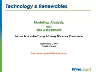
Technology & Renewables Modeling, Analysis, and Risk Assessment Kansas Renewable Energy & Energy Efficiency Conference September 26, 2007 Topeka, Kansas Grant Brohm – grantb@WindLogics.com
WindLogics Background • Founded 1989 - supercomputing background • Atmospheric modeling and visualization • US Air ForceOperational Weather Squadrons • Israeli Air ForceOperational Forecasting System • Harvard UniversityAir Quality Modeling • DOEReal-time Wind Field Monitoring • NASAMeteorological Data Assimilation • Experience in fine-scale forecasting systems • Applied these advanced modeling and analysis technologies to wind energy since 2002 • Subsidiary of FPL Energy since September 2006
WindLogics Today • 46 people focused on 3 things: • Wind Resource – over 700 studies completed • Wind Variability – 40-year analysis standard • Wind Forecasting – currently ~5000 MW • Grand Rapids Sciences Center • Ph.D. atmospheric sciences team for R&D • 150 processors & 36 terabytes of storage • Data center with NOAAport Satellite System • Saint Paul Operations Center • Meteorology and GIS production, Sales, Operations • 400 processors & 90 terabytes of storage • Data center with NOAAport Satellite System
Atmospheric Complexity The atmosphere is a dynamic and complex space… Solar Radiation Convection Moisture Fluxes Condensation Turbulence Surface Heat Evaporation
Complexity of Wind Energy • Location & terrain make big difference • Power in the wind is proportional to the cube of wind speed, so great value in optimizing location, layout & height • Many characteristics to consider • Shear (speed increase with height) • Diurnal & seasonal patterns • Long-term interannual variability • Planning, financing & operating issues • A large investment with a 25-year timeline • Variability on many time scales • Implications for utility operations
Integrated Wind Understanding Taking advantage of all available data: • Meteorological tower data and other on-site weather measurements • Use best available “gridded” archives of real weather data from government agencies • Actual recorded weather data from many sources • Typically used to initialize weather forecast models • Add the best available high-resolution topography and land cover information • Properly apply meteorological models and wind field models - integrating data over space and time • Analyze long-term variation and the financial impact on your specific situation • Use wind forecasting to minimize cost and operating impacts & maximize revenues
Atmospheric Complexity The atmosphere is so complex… So how does this work? Solar Radiation Convection Moisture Fluxes Condensation Turbulence Surface Heat Evaporation
Gridded 3D Weather Data Integrates all available data sources, from the surface to the upper atmosphere, into a unified and physically consistent state of all grid cells at a given point in time. • Over 160 weather variables collected from: • Surface / METAR station data • Oceanographic buoys • Ship reports • Aircraft (over 14,000 ACARS/day) • NOAA 405 MHz profilers • Boundary-layer (915 MHz) profilers • Rawinsondes (balloon soundings) • Reconnaissance dropwinsonde • RASS virtual temperatures • SSM/I precipitable water • GPS total precipitable water • GOES precipitable water • GOES cloud-top pressure • GOES high-density vis. cloud drift wind • GOES IR cloud drift winds • GOES cloud drift winds • VAD winds: WSR-88D NEXRAD radars
Meteorological Models • Numerical gridded representation of the laws of physics • Conservation relations • Mass • Energy • Momentum • Water, etc. • Physical processes • Radiation • Turbulence • Soil/ocean interactions, etc. • Use lots of fast computers • Partial differential equations • Gridpoint difference values • Step all points through time using very small steps (a few seconds per step)
March 2003 Modeling from Weather Data Archives Wind vectors at 90 m and precipitation rate on outer grid at 6 hr/sec Month of March 2003 Note the Historic Front Range snow storm (March 17-19, 2003)
Understanding Project Sites in Detail • Example showing wind speed in color, wind direction as streamlines. • Data Sources: • WindLogics Archive • Local Test Towers • Hi-Res. Terrain / Land Cover • Process: • Detailed Windfield Modeling • Result: • 30 meter grid • 50 meter hub height 30m Grid (5x6 km)
Gross Annual Production Production estimate in GWh per year at multiple heights 30m Grid (5x6 km) 30m Grid (5x6 km) 50m Height 80m Height
Variability over Years (Annual Energy - 1972–2002)
Long-Term Wind Speed Variations A fairly low variability site, Annual Std. Dev. ~ 3.5% – yet the choice of 8-year period can affect energy projection by ~20%
Site Assessment Results Understanding the resource, variability & risk
Conclusions • Benefits of Modeling? • Allows us to determine wind regime (and its drivers) over project area • Can be completed faster than traditional measurement (4-6 weeks) • Best if modeling is integrated with met tower or other on-site data • Provides a method for moving more efficiently through development cycle • Important Risk Analysis Components? • Wind resource analysis should incorporate long-term data for meaningful correlation and prediction • Potential climate cycles and trends should be identified • Long-term data needed for more accurate P-values (sensitivity) • Key Concepts? • Need understanding of long-term wind variability profile to best anticipate wind farm production • Best to use integrated approach (models, met towers, archived data, multiple correlation techniques) for most error-proof expected wind production baseline
WindLogics Inc. Time series showing forecast with wind speed and cloud cover Grant Brohm, Sales 651.556.4279 grantb@WindLogics.com www.WindLogics.com