Download
1 / 1
10 likes | 133 Views
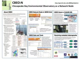
The Chesapeake Bay Environmental Observatory (CBEO) project creates a prototype of cyberinfrastructure (CI) for environmental observatories, aimed at enhancing scientific understanding of Chesapeake Bay's ecosystems. The initiative focuses on four main activities: integrating testbed CI into national networks, promoting education and outreach, supporting research in environmental management, and developing a CBEO portal for data access. Key features include a distributed hydrologic information system, observational data integration, and tools for visualizing and analyzing water quality and hydrodynamic data related to Chesapeake Bay.

E N D
Metadata Std #1(e.g., FGDC) ControlledVocabulary #1(e.g., MD DNR) Mapper Mapper Controlled Vocabulary #2(e.g., USGS) Metadata Std #2(e.g., ISO) CBEO:N Chesapeake Bay Environmental Observatory as a Network Node http://geon16.sdsc.edu:8080/gridsphere About CBEO CBEO Network Node in GEON Grid CBEO Node in CUAHSI HIS • The mission of the CBEO project is development of a Chesapeake Bay Environmental Observatory as a prototype of cyberinfrastructure (CI) for environmental observatory networks (EONs) demonstrating the transformative power of CI. • The project is organized around the following four concurrent and interacting activities: • CBEO:N incorporates the test bed CI into the national EONs • by constructing a GEON-based node and a CBEO web portal • by developing a CUAHSI-HIS-based node, available under the same portal • by prototyping CBEO tools that can be re-used through the portal • CBEO:E is the education and outreach element, with the mission to translate observational science for public consumption • MAST: Multicultural students At Sea Together, Hampton Ubiversity. • Field Courses, Science Workshops • Center for Ocean Science Excellence for the Mid-Atlantic region (COSEE-MA) • CBEO:S provides science, engineering, and management research context for various cyberinfrastructure tools and techniques • focus on hypoxia in Chesapeake Bay, in particular non-linear O2 responses to management and climate; effects of land use, water quality, hydrodynamics, biota, etc. • CBEO:T constructs a locally accessible CBEO test-bed prototype • managing 10 years of Chesapeake Bay water quality and hydrodynamics model • CIMS, MD DNR, overflightchl-a • spatial indexing for cross- data set queries CUAHSI HIS (Consortium of Universities for the Advancement of Hydrologic Sciences, Inc., Hydrologic Information System) develops a distributed network of hydrologic services and applications for sharing and integrating observational data. An HIS Server for the Chesapeake Bay area is available on the CBEO portal. It provides access to CBEO datasets using a common language (WaterML) Data Access System for Hydrology (DASH) application for the Chesapeake Bay area, available via the portal Visualization of registered spatial data Hydroseek, an application for ontology-aware search for hydrologic observations, is also available via the portal, as part of “CBEO Tools”. It allows users to find and assemble information from multiple observation networks regardless of structural and semantic differences between them. Querying CBEO relational databases registered to the portal The GEON-based portal supports publication, discovery, analysis, visualization and integration of data resources registered by portal users, or available elsewhere in GEON-managed portals CBEO Data and Tools Resolving metadata heterogeneity Many types of resources can be registered to the CBEO portal, including shapefiles, Excel spreadsheets, relational databases, ASCII files, GMT rasters, KML, geoTIFF,XML, NetCDF files, documents (Word, Powerpoint, PDF), applications and services (WMS, WFS), web sites. CBEO data available via the portal include CIMS observations data, model runs, aircraft remote sensing data, model grids, station locations, estuary maps, and education data. Within CBEO:N, several commonly-used Chesapeake Bay datasets are converted into CUAHSI ODM (Observations Data Model), made accessible via WaterOneFlow web services, and registered to CUAHSI’s HISCentral application (hiscentral.cuahsi.org). This makes the datasets available within the national network of hydrologic observations. CUASHI “Observations Data Model” (ODM) Schema CIMS Chesapeake Information Management System (http://www.chesapeakebay.net/cims/index.htm) MAST Multicultural students At Sea,Together (http://www.hamptonu.edu/academics/schools/science/marine/mast/) 10-year run Chesapeake Bay Water Quality and Hydrodynamics (2 hr time step) An R-based interpolator developed by Rebecca Murphy from JHU and used to model hypoxia in the Bay, is now available via the portal, as part of CBEO tools. Funding : National Science Foundation under Grant No. BES-0618986:"CEO:P--A Prototype System for Multi-Disciplinary Shared Cyberinfrastructure: Chesapeake Bay Environmental Observatory (CBEO)“ . Participants: William P. Ball, Randal Burns (Johns Hopkins University), Ben Cucker(Hampton University), Dom Ditoro (University of Delaware), AlexeyVoinov (Chesapeake Research Consortium), Mike Kemp, Laura Murray (University of Maryland) , Michael Piasecki (Drexel University), IlyaZaslavsky (San Diego Supercomputer Center) Spatial Information Systems Lab, San Diego Supercomputer Center, University of California San Diego, zaslavsk@sdsc.edu