Download
1 / 7
70 likes | 94 Views
This article discusses the current uses of Mandli Photolog data, including viewing images and extracting inventory features such as bridges, culverts, and signs. It also explains how to integrate the data to update and expand the centerline network.

E N D
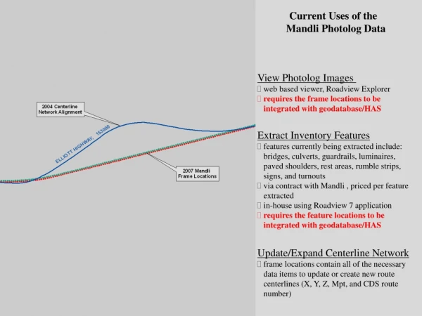
Current Uses of the Mandli Photolog Data • View Photolog Images • web based viewer, Roadview Explorer • requires the frame locations to be • integrated with geodatabase/HAS • Extract Inventory Features • features currently being extracted include: • bridges, culverts, guardrails, luminaires, • paved shoulders, rest areas, rumble strips, • signs, and turnouts • via contract with Mandli , priced per feature • extracted • in-house using Roadview 7 application • requires the feature locations to be • integrated with geodatabase/HAS • Update/Expand Centerline Network • frame locations contain all of the necessary • data items to update or create new route • centerlines (X, Y, Z, Mpt, and CDS route • number)
Integrating MandliPhotolog Data Photolog Frame Locations • Geodatabase Centerline Network • CDS route number – 292000 • route name – Craig/Klawock/ Hollis Hwy • area shown – mpt 27.980 to 28.300 • Original Frame Locations • green circles – forward inventory direction • red circles – reverse inventory direction • Integrated Frame Locations • black circles – snapped frame locations on • the CDS route • extracted CDS route mpt value for each • frame location • Integrated Product • snapped frame location table is exported • to the geodatabase for use with GIS or • Roadview Explorer (web based • photolog viewer)
Integrating MandliPhotolog Data Features Extracted From the Photolog Data Extracted Features Include: bridges, culverts, guardrails, luminaires, paved shoulders, rest areas, rumble strips, signs, and turnouts • Geodatabase Centerline Network • CDS route number – 292000 • route name – Craig/Klawock/ Hollis Hwy • area shown – mpt 27.980 to 28.300 • Original Feature Locations • green squares – sign locations • Integrated Feature Locations • snapped sign locations on CDS route • extracted CDS route mpt value for each • sign location • Integrated Product • snapped sign location table is exported • to the geodatabase for use with GIS, HAS, • and MMS
Integrating Mandli Photolog Data Example of Extracted Features Following Integration
Update/Expand Centerline Network • Frame Locations • frame locations contain all of the necessary • data items to create route centerlines (X, Y, • Z, Mpt, and CDS route number) • could be used to update a realigned section • of the centerline network • could be used to create a new route to be • added to the centerline network