Download
1 / 8
80 likes | 441 Views
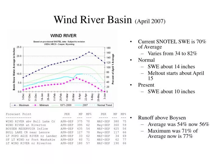
Wind River Basin (April 2007). Current SNOTEL SWE is 70% of Average Varies from 34 to 82% Normal SWE about 14 inches Meltout starts about April 15 Present SWE about 10 inches Runoff above Boysen Average was 54% now 56% Maximum was 71% of Average now is 77%.

E N D
Wind River Basin (April 2007) • Current SNOTEL SWE is 70% of Average • Varies from 34 to 82% • Normal • SWE about 14 inches • Meltout starts about April 15 • Present • SWE about 10 inches • Runoff above Boysen • Average was 54% now 56% • Maximum was 71% of Average now is 77% Forecast Point PER MP MP% PER MP MP% -------------- ----- --- --- ----- --- --- WIND RIVER abv Bull Lake Cr APR-SEP 375 70 MAY-SEP 380 75 WIND RIVER at Riverton APR-SEP 395 62 May-SEP 360 59 BOYSEN RESERVOIR Inflow APR-SEP 435 54 MAY-SEP 425 56 BULL LAKE CR near Lenore APR-SEP 127 70 May-SEP 117 66 LT POPO AGIE RIVER nr Lander APR-SEP 33 62 MAY-SEP 34 69 SF LT WIND nr Fort Washakie APR-SEP 60 71 MAY-SEP 62 77 LT WIND RIVER nr Riverton APR-SEP 180 57 MAY-SEP 190 66
Wind River Basin (April 7th,2008) • Currently SNOTELs are 97% • Varying from 88 to 111% • Normal • SWE @ 14.3" • Meltout starts April 15 • Present • SWE @ 13.9“ • SWSI • SWSI @ -0.72 • Runoff above Boysen @ 4-1 • Average is 96% • Maximum is 106% Forecast Point PER MP MP% PER MP MP% --------------------------- ------- --- --- ------- --- --- WIND RIVER abv Bull Lake Cr APR-JUL 445 102 APR-SEP 550 103 WIND RIVER at Riverton APR-JUL 535 98 APR-SEP 635 99 BOYSEN RESERVOIR Inflow APR-JUL 685 96 APR-SEP 775 96 BULL LAKE CR near Lenore APR-JUL 130 88 APR-SEP 160 88 LT POPO AGIE RIVER nr Lander APR-JUL 41 89 APR-SEP 47 89 SF LT WIND nr Fort Washakie APR-JUL 77 106 APR-SEP 86 102 LT WIND RIVER nr Riverton APR-JUL 255 91 APR-SEP 285 91
Big Horn River Basin (April 2007) • Current SNOTEL 75% of Average • Varies from 36 to 105% • Normal • SWE about 13 inches • Meltout starts about April 15 • Present • SWE about 10 inches • Runoff • Basin Average is 60% of average • Maximum is 89% of Average Forecast Point PER MP MP% PER MP MP% -------------- ----- ---- --- ----- --- --- BOYSEN RESERVOIR Inflow APR-SEP 435 54 MAY-SEP 425 56 GREYBULL RIVER nr Meeteetse APR-SEP 135 68 MAY-SEP 136 70 SHELL CREEK nr Shell APR-SEP 64 89 MAY-SEP 59 86 BIGHORN RIVER at Kane APR-SEP 670 60
Big Horn River Basin (April 7th, 2008) • Currently SNOTELs are 100% • Varying from 73 to 196% • Normal • SWE about 14.7 inches • Meltout starts @ April 15 • Present • SWE about 14.8 inches • SWSI @ -0.27 • Runoff @ 4-1 • Basin Average is 98% • Maximum is 105% • Minimum is 91% Forecast Point PER MP MP% PER MP MP% -------------------------- ------- ---- --- ------- ---- --- BOYSEN RESERVOIR Inflow APR-JUL 685 96 APR-SEP 775 96 GREYBULL RIVER nr Meeteetse APR-JUL 135 91 APR-SEP 183 92 SHELL CREEK nr Shell APR-JUL 63 105 APR-SEP 75 104 BIGHORN RIVER at Kane APR-SEP 980 98 APR-SEP 1090 98
Shoshone River Basin (April 2007) • Current SNOTEL 64% of Average • Varies from 27 to 85% • Normal • SWE about 19.5 inches • Meltout starts about April 15 • Present • SWE about 12.7 inches • Runoff • Basin Average is 77% of average • Maximum is 86% of Average • Minimum is 59% of average Forecast Point PER MP MP% PER MP MP% -------------- ----- --- --- ----- --- --- NF SHOSHONE RIVER at Wapiti APR-SEP 435 84 MAY-SEP 415 86 SF SHOSHONE RIVER nr Valley APR-SEP 167 63 MAY-SEP 179 70 SF SHOSHONE abv Buffalo Bill APR-SEP 145 64 MAY-SEP 126 59 BUFFALO BILL DAM Inflow (2) APR-SEP 605 75 MAY-SEP 545 72 CLARKS FORK RIVER nr Belfry APR-SEP 475 80 MAY-SEP 475 83
Shoshone River Basin (April 7th, 2008) • Currently SNOTELs @ 99% • Varying from 73 to 113% • Normal • SWE @ 18.8 " • Meltout starts about April 22 • Present • SWE @ 18.7" • SWSI @ 3.22 • Runoff @ 4-1 • Basin Average @ 118% • Maximum of 122% • Minimum of 108% Forecast Point PER MP MP% PER MP MP% ---------------------------- ------- --- --- ------- --- --- NF SHOSHONE RIVER at Wapiti APR-JUL 530 115 APR-SEP 600 115 SF SHOSHONE RIVER nr Valley APR-JUL 250 111 APR-SEP 295 111 SF SHOSHONE abv Buffalo Bill APR-JUL 245 114 APR-SEP 255 113 BUFFALO BILL DAM Inflow (2) APR-JUL 790 110 APR-SEP 870 108 CLARKS FORK RIVER nr Belfry APR-JUL 655 121 APR-SEP 725 122
Powder-Tongue River Basins (April 2007) • Current SNOTEL 91% of Average • Varies from 53 to 107% • Normal • SWE about 11.5 inches • Meltout starts about April 15 • Present • SWE about 10.5 inches • Runoff • Basin Average is 82% of average • Maximum is 98% of Average • Minimum is 72% of average Forecast Point PER MP MP% PER MP MP% -------------- ----- --- --- ----- --- --- TONGUE RIVER nr Dayton (2) APR-SEP 111 102 MAY-SEP 98 95 BIG GOOSE nr Sheridan APR-SEP 60 100 MAY-SEP 55 95 LITTLE GOOSE nr Bighorn APR-SEP 43 102 MAY-SEP 39 98 TONGUE RIVER RESERVOIR Inflow APR-SEP 240 96 MAY-SEP 210 93 MIDDLE FORK POWDER nr Barnum APR-SEP 13.6 73 NORTH FORK POWDER nr Hazelton APR-SEP 7.8 75 ROCK CREEK nr Buffalo APR-SEP 14.9 62 PINEY CREEK at Kearney APR-SEP 39 72 POWDER RIVER at Moorehead APR-SEP 145 63 MAY-SEP 143 72 POWDER RIVER nr Locate APR-SEP 160 62
Powder-Tongue River Basins (April 7th, 2008) • Currently SNOTELs @ 108% • Varying from 85 to 196% • Normal • SWE @ 11.1" • Meltout starts about April 15 • Present • SWE @ 12" • SWSI @ 2.20 • Runoff @ 4-1 • Basin Average @ 108% • Maximum is 117% • Minimum is 102% Forecast Point ER MP MP% PER MP MP% ---------------------------- ------- ---- --- ------- ---- --- TONGUE RIVER nr Dayton (2) APR-JUL 100 104 APR-SEP 113 104 BIG GOOSE nr Sheridan APR-JUL 55 106 APR-SEP 63 105 LITTLE GOOSE nr Bighorn APR-JUL 35 103 APR-SEP 43 102 TONGUE RIVER RESERVOIR Inflow APR-JUL 235 107 APR-SEP 260 104 MIDDLE FORK POWDER nr Barnum APR-JUL 18.6 105 APR-SEP 19.4 104 NORTH FORK POWDER nr Hazelton APR-JUL 11.2 117 APR-SEP 12 115 ROCK CREEK nr Buffalo APR-JUL 23 116 APR-SEP 27 113 PINEY CREEK at Kearney APR-JUL 57 116 APR-SEP 60 115 POWDER RIVER at Moorehead APR-JUL 230 112 APR-SEP 260 113 POWDER RIVER nr Locate APR-JUL 265 113 APR-SEP 300 115