Download
1 / 28
340 likes | 757 Views
Geog 469 GIS Workshop. Data Acquisition. Outline. Data Acquisition Acquiring spatial data Metadata Spatial data quality Determining fitness-for-use of data Spatial Data Infrastructure (SDI) Concepts of SDI Charactizing of SDI. Part I. Data Acquisition.

E N D
Geog 469 GIS Workshop Data Acquisition
Outline • Data Acquisition • Acquiring spatial data • Metadata • Spatial data quality • Determining fitness-for-use of data • Spatial Data Infrastructure (SDI) • Concepts of SDI • Charactizing of SDI
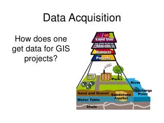
Part I. Data Acquisition Evaluating the applicability of data is one of essential skills for GIS professionals
Acquiring spatial data • Use data download service • USGS National Map Seamless Data Distribution System http://seamless.usgs.gov • USGS EROS Data Center http://eros.usgs.gov/ • Microsoft’s Terraserver http://terraserver.microsoft.com/ • TIGER/Line by Census Bureau or ESRI • http://www.census.gov/geo/www/tiger/tiger2002/tgr2002.html • http://www.esri.com/data/download/census2000_tigerline/index.html • Subnational GIS clearing house such as WAGDA • http://wagda.lib.washington.edu/ • Read http://courses.washington.edu/geog360a/dataatlibs2007.ppt if you’re not familiar with UW library system • Use data catalog service (or spatial portal) • Geospatial one-stop http://www.geodata.gov • ESRI geography network http://www.geographynetwork.com/
Tips for spatial & non-spatial data acquisition • By geographic scale • Data resolution is often related to the geographic scale of data providing agency being considered • federal data sources have lower resolution with wider geographic coverage (e.g. LU/LC in EROS Data Center) • parcel data can be found in the local level (e.g. City of Seattle) • By related agency and organizations • Best data about housing can be found in HUD… • Best data about transportation can be found in BTS… • Best data about education can be found in NCES… • Best data about justice can be found in BJS… • By theme • Talk to resource persons in the area; they probably have go through data search processes
Metadata • Describes characteristics of data, including content • Helps determine fitness for use • Is the data suitable for the application? • Is metadata always available? • No (much shared data is more likely to be published with metadata e.g. USGS public domain data) • What if metadata is not available? • Look for data dictionary at least; or contact persons in charge • Metadata standard for public data in the U.S. • FGDC metadata content standard (www.fgdc.gov)
Reading FGDC metadata Never miss reading abstract and purpose! Example: http://wa-node.gis.washington.edu/~uwlib/10mdem.html
Creating metadata • How do I create metadata? • Use metadata creation/editing tool • ArcCatalog from ESRI • tkme from http://geology.usgs.gov/tools/metadata/tools/doc/tkme.html • How do I check if this metadata conforms to FGDG Content Standard? • Use metadata validation tool • Install program mp from http://geology.usgs.gov/tools/metadata/tools/doc/mp.html • Use web service at http://geo-nsdi.er.usgs.gov/validate.php
Spatial data quality where • Column: components of geographic information • Row: components of data quality • Accuracy: lack of discrepancy between measurement and values considered true (e.g. is this location near true value?) • Consistency: whether given components conform to logical rules (e.g. any digitizing error?) • Completeness: whether what’s required is encoded in data (i.e. anything missing) How is spatial data quality related to fitness for use of data? FGDC metadata terms
Determining fitness for use* • Does map scale or resolution of the data provide the level of details required by the application? • Using low-resolution satellite image for street-level survey is not acceptable • Any generalization algorithms used? • Is data current enough to support needs identified from Stage 1? • Using outdated data for replacing a old map is not acceptable • Are specific characteristics of data useful for the application? • Topology for routing operation • Multispectral image for land use detection • Non-planar representation for 3D visualization • Any processing steps linked to usefulness of data for specific applications? • Some processing steps brought about irreversible effects on data (e.g. unknown algorithm parameters) *Questions in this lecture are not necessarily exhaustive
Determining fitness for use • Is the stated level of accuracy sufficient given error tolerance? • Requirements for accuracy vary highly by the applications • Required types of accuracy vary by need-to-know questions or research questions (e.g. measuring parcel size require relative accuracy while surveying require absolute accuracy) • Is the state level of completeness of features or attribute adequate to need-to-know question? • Some entities and attributes are required rather than optional • Logical consistency of data? • Doesn’t data lack conformance to logical rules? (e.g. is identifier generated properly? Doesn’t data has too many sliver?) • Does metadata indicate that the agency put any effort in quality control? (e.g. lack of information in data quality section)
Part II. Spatial Data Infrastructure Searching for the day we experience less pain in data acquisition
Role of geographic information • Information about data use shows that 80% of government-related activities require locational information • Business demands exist to analyze customers’ need on a locational basis • Major concern for understanding complexity of human and natural environment interaction • Sustainability has been widely acknowledged as a future agenda in varying organizational structure
Spatial data integration Thematic integration Spatial integration Locational framework acts as integrating mechanism
Data Futures… • Imagine the future when information is extracted from data upon request • In the future, data is right there, and different data are integrated in a seamless manner so that value-added products can be generated in a timely fashion • What are barriers to getting there? Are we getting there? What are steps towards making the best use of spatial data?
Spatial data sharing challenges • What if there’s no metadata for a dataset? • What if there are no people who know characteristics and constraints attached to spatial data? • What if there’s no website for data dissemination? • What if there’s no standards that promote interoperability (e.g. FGDC metadata content standard)? • What if there’s no coordination between agencies? • What if there’s no willingness to share data?
Spatial data as infrastructure • What is a data infrastructure, e.g. gas, electric, highway? • Spatial data together with the means to create, maintain, extract, and disseminate spatial data. • SDI = spatial data + people + technology + standards + policy • SDIs provide enabling environment that facilitates communication • Due to its dynamic and incremental nature (user-driven & successive developments of SDIs on top of the existing infrastructure), it is not straightforward to measure benefit for SDI
Characterizing SDI • SDIs are shared • seek to make available, expensive, geo-referenced spatial data digitally to a variety of users for diverse application needs (for example, biodiversity, utilities, and health) based on anintegrated approach. • SDIs are open • no pre-defined boundaries limiting the usergroups are made, and typically various government departments, citizens, andprivate sector are expected to draw upon them. • SDIs are inherently enabling • not pre-configured to a particular application and can potentially be usedby different entities to design their own applications. Groot and McLaughlin 2000
Spatial data as commodity • Spatial data infrastructure provides enabling environment for a spatially enabled society • Geographic information is widely used to support decision-making • Seen as assets promoting • good governance • economic development • improved environmental sustainability • Seen as push towards information society • Access to applicable spatial data is essential to this endeavor
US SDI • Spatial Data Infrastructure, e.g. three levels • 12 Federal Agencies – geoplatform.gov • 50 States (National States Geographic Information Councils) • Regional (e.g. Washington State Geographic Data Archive)
US Federal SDI – current architecture Jerry Johnston, US EPA, presentation to NGAC “Status Update: Geospatial Platform” http://www.fgdc.gov/ngac/meetings/march-2011/intergovernmental-subcommittee-update.pptx
US Federal SDI – next architecture Jerry Johnston, US EPA, presentation to NGAC “Status Update: Geospatial Platform” http://www.fgdc.gov/ngac/meetings/march-2011/intergovernmental-subcommittee-update.pptx
Regional SDIWashington State Geospatial Data Archive (WAGDA) 1.0
Data Access Services • currently in development ● supported - ○ unverified - (blank) not supported - (grey) not preferred