Download
1 / 1
10 likes | 144 Views
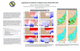
128E 130E 132E 134E 136E 138E 140E 142E. 1/8° winter. 1/16° winter. 1/8° summer. 1/16° summer. Japan/East Sea Hybrid Coordinate Ocean Model (HYCOM). Impact of resolution on deep and surface circulation.

E N D
128E 130E 132E 134E 136E 138E 140E 142E 1/8° winter 1/16° winter 1/8° summer 1/16° summer Japan/East Sea Hybrid Coordinate Ocean Model (HYCOM) Impact of resolution on deep and surface circulation Zonal and meridonal cross sections of temperature 1/8° surface layer mean speed and currents 1/16° surface layer mean speed and currents Abstract: HYCOM is a generalized (hybrid isopycnal/sigma/z) vertical coordinate ocean circulation model. It is isopycnal in the open stratified ocean, but reverts to a terrain-following coordinate in shallow coastal regions, and to z-level coordinates near the surface in the mixed layer. This generalized vertical coordinate approach is dynamic in space and time via the layered continuity equation, and permits the existence of zero thickness layers. Hence HYCOM allows for an accurate transition between deep and shallow water, historically a difficult problem for ocean models. It also allows high vertical resolution where it is most needed, over the shelf and in the mixed layer. The isopycnal coordinate reduces the need for high vertical resolution in deep water. JES-HYCOM is funded by the Office of Naval Research. HYCOM development is also funded by the National Ocean Partnership Program (NOPP) in a collaborative effort with the University of Miami (E. Chassignet), Los Alamos National Laboratory (R. Bleck), and the University of Minnesota (M. Okeefe). The long term goals of the project are to make HYCOM a state of the art community ocean model with data assimilation capability which can (1) be used in a wide range of ocean-related research, (2) be used in a next generation eddy-resolving global ocean prediction system, and (3) be coupled to a variety of other models, including atmospheric, ice, and biological. 128E 130E 132E 134E 136E 138E 140E 142E Patrick J. Hogan and Harley E. Hurlburt Naval Research Laboratory, Code 7323, Stennis Space Center, MS, 39529-5004, USA hogan@nrlssc.navy.mil 1/8° deep layer mean speed and currents • JES-HYCOM characteristics: • Generalized vertical coordinate ocean model • includes realistic coastline geometry and bottom topography, including the shelf • forced by ECMWF 10 m reanalysis monthly climatological (1979-1993) wind and atmospheric forcing • K-Profile Parameterization (KPP) mixed layer (or K/T as an option) • vertical resolution: 15 layers • 2 Sv barotropic throughflow • bimonthly relaxation to temperature and interface depth at the straits • bimonthly relaxation to MODAS SST and SSS • currently no assimilation of oceanic data 1/16° deep layer mean speed and currents The impact of increasing the horizontal grid resolution on the mesoscale circulation dynamics has been demonstrated by Hogan and Hurlburt (2000) with the NRL Layered Ocean Model (NLOM). These results, although preliminary in nature, also show the impact of grid resolution on mean flow patterns. In particular, the surface circulation near Vladivostok reverses from anticyclonic at 1/8° to cyclonic at 1/16°, which is supported by most observations. Another benefit of increased resolution is the ability to resolve the bottom topography. This is clearly illustrated by the appearance of the sigma levels over the shelf region just east of the Noto Peninsula. Future plans for HYCOM include forcing with high frequency atmospheric forcing and assimilation of observed oceanic data. 128E 130E 132E 134E 136E 138E 140E 142E These panels show the impact of increased horizontal grid resolution. At 1/8° there is unrealistic anticyclonic surface flow near Vladivostok (top left) . At 1/16° (top right) this flow is cyclonic as observed. The corresponding deep flow (Layer 11, the 27.10 isopycnal) patterns are shown below. The deep flow at 1/16° is in general agreement with recent current meter measurements by Takematsu (1999). Cross sections of temperature from the 1/8° (left) and 1/16° (right) HYCOM model during winter (top) and summer (bottom). During the summer, the mixed layer is maintained at 12 m. During the winter, the mixed layer is diagnostically determined (0.2 sigma-t from the surface). Vertical resolution in the mixed layer is maintained via z-levels during the winter, when densities are colder than “target” densities. These z-levels revert to isopycnals during the summer. The impact of resolving the bottom topography is clearly illustrated by the appearance of the sigma levels over the shelf region in zonal section from the 1/16° simulation during winter.