Download

1 / 35
0 likes | 15 Views
Hurricane Harvey, a record-breaking storm, made landfall in the US causing extensive damage, displacements, and deaths. From its formation to devastating landfalls and aftermath, the storm led to massive rescue operations, evacuations, and establishment of shelters. The timeline of events showcases the significant impact on regions like Texas and Louisiana, highlighting the urgency and coordinated efforts in response to the disaster.

E N D
Office of Homeland Security and Emergency Preparedness Hurricane Harvey August 17 – August 31

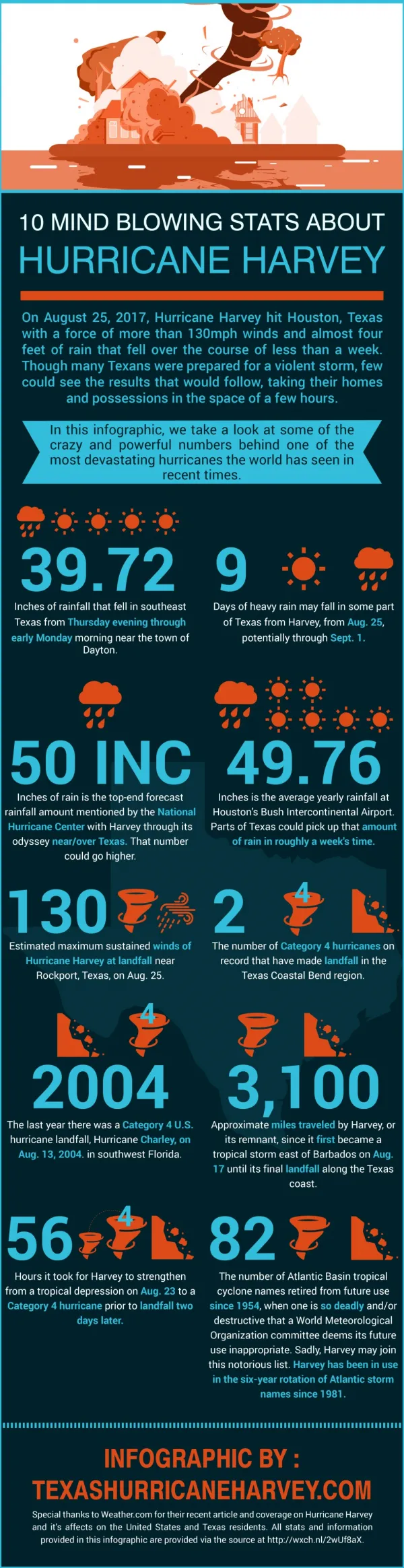
Historical Facts • The eighth named storm of 2017 • First Major Hurricane to make landfall in the United State since Hurricane Wilma in 2005. • Tied with Hurricane Katrina as the most costliest tropical cyclone on record, inflicting $125 billion in damage. • Floods inundated hundreds of thousands of homes, displaced more than 30,000 people, and prompted more than 17,000 rescues. • Harvey caused at least 106 confirmed deaths in the United States.

Creation of Hurricane Harvey • Harvey developed from a tropical wave to the east of the Lesser Antilles, reaching tropical storm status on August 17. • Harvey began to weaken due to moderate wind shear, and degenerated into a tropical wave north of Colombia, early on August 20. • Reach H-120 for Louisiana on August 21. • National Weather Service (NWS) Lake Charles, predicts a Category 1 hurricane with a storm surge of 6 – 8 inches for Calcasieu Parish

Hurricane Harvey Full Storm Track August 21 OHSEP starts tracking H-120

Wednesday August 23rd Calcasieu Parish Emergency Operation Center Level 2 Declaration of Emergency was drafted, signed and filed by August 24th • Planning for a 6-8 storm surge began • Sandbagging Operations became priority • Landfall was predicted for Friday August 25th • Cameron Parish issued mandatory evacuation •

Hurricane Harvey enters the Gulf of Mexico • The remnants were monitored for regeneration as it continued west- northwestward across the Caribbean and the Yucatán Peninsula. • Started to redevelop over the Bay of Campeche on August 23. • Harvey then began to rapidly intensify on August 24, regaining tropical storm status and becoming a hurricane later that day.

Thursday August 24th • Harvey started to slow and gain strength and was predicted to make landfall as a major hurricane • Sandbagging Operations remained priority. • Landfall was moved to Saturday August 26th.

Major Hurricane Status • Became a major hurricane and attained Category 4 intensity on August 25th. • Harvey made landfall around August 26, 03:00 UTC at San José Island, Texas, at peak intensity (130 mph winds). • Second landfall on the Texas mainland (Holiday Beach ) three hours later as a Category 3 hurricane. • After striking land, Harvey rapidly weakened as its speed slowed dramatically to a crawl, and weakened to a tropical storm on August 26. • For about two days the storm stalled just inland, dropping very heavy rainfall and causing widespread flash flooding.

Friday August 25that 2300 Landfall


Hurricane Harvey moves toward Louisiana • Harvey's center drifted back towards the southeast, ultimately re-emerging into the Gulf of Mexico on Monday August 28. • On Wednesday August 30, it made its third and final landfall just west of Cameron, Louisiana, with winds of 45 mph (75 km/h).

Wednesday August 30that 1400 Third Landfall Opened Civic Center as a shelter •

Search and Rescue and First Major Shelter • Calcasieu Parish Search and Rescue Operations began on the night of Saturday August 26th. • Over 157 missions were conducting rescuing approximately 600 citizens. • On Sunday August 27thLake Charles Civic Center was opened as a shelter. • With a capacity of 720.
August 28ththrough August 30th Search and Rescue Missions in Calcasieu Parish EOC Level 1

Texas Evacuation • Wednesday August 30th, Texas EMA requested assistance for citizens of Orange, Vidor, and parts of Beaumont. • LA State Police notified Calcasieu Parish OHSEP of the need for a rescue mission. • Calcasieu Parish OHSEP requested LA National Guard Support for SAR operations in Texas and established two evacuation centers. • A forward command post was established and Maj. Duplechin took command of the LANG Soldiers with the integration of a Calcasieu Parish Emergency Management Team. • Over 3,000 citizens where moved to Lake Charles within the first 24 hours.

Wednesday August 30thto Friday September 1st Texas Evacuation to Lake Charles Approximately 5,000 citizens where rescued and transported to Lake Charles

Second Shelter • On Wednesday August 30ththe Burton Coliseum was opened as a Red Cross Shelter for the displaced Texas citizens. • The center capacity was 450 people. • The shelter was at capacity within 4 hours.

Bus Exchange Point • On Thursday August 31st, operations began to transport Texas citizens from Lake Charles to the state run Mega-Shelter in Alexandria LA. • Over 3,000 citizens were transferred total.
Thursday August 31stto September 2nd Transferring Houston citizen to Mega - Shelter Alexandria

Sabine River Flooding • On Friday September 1st, the Calcasieu Parish OHSEP in conjunction with the Calcasieu Parish Sheriff’s Office and LA Wildlife and Fisheries started working the Sabine River Flooding. • SAR missions were conducted and temporary shelters established in Vinton, LA and Starks, LA. • Over 2,000 residents had the potential of being displaced from their homes and over 1,000 various public and private structures were at risk of flooding.

Sept 2ndSabine River flooded coming close to the 2016 flood


![[PDF] Free Download And the Rest is History By Jodi Taylor](https://cdn4.slideserve.com/8196924/slide1-dt.jpg)


![[R.E.A.D] Artcurious: Stories of the Unexpected, Slightly Odd, and Strangely Wonderful in Art History Full](https://cdn5.slideserve.com/11083984/slide1-dt.jpg)
![[PDF] Free Download How the Word Is Passed: A Reckoning with the History of Slavery Across America Full](https://cdn5.slideserve.com/11093489/slide1-dt.jpg)

![[Epub] The Immortality Key: The Secret History of the Religion with No Name Full](https://cdn5.slideserve.com/11105059/slide1-dt.jpg)
![[Epub] Humankind: A Hopeful History Full](https://cdn5.slideserve.com/11106244/slide1-dt.jpg)