Download
1 / 17
170 likes | 202 Views
This analysis aims to improve high-resolution global precipitation estimates in high latitudes using AMSR, Cloudsat, AIRS, and GPCP data. The goal is to develop merging procedures and fallback techniques to enhance the accuracy of precipitation measurements.

E N D
High Latitude Precipitation: AMSR, Cloudsat, AIRS and GPCP, too Bob Adler (U. of Maryland/NASA Goddard) Eric Nelkin (SSAI/NASA Goddard) Dave Bolvin (SSAI/NASA Goddard) George Huffman (SSAI/NASA Goddard)
Motivation TRMM Multi-satellite Precipitation Analysis (TMPA) limited to 50°N-50°S--desire high time resolution global analyses approaching and through the GPM era TMPA Approach • Take advantage of current and future developments by others in precipitation estimation applicable at high latitudes (e.g., high frequency microwave [150-200 GHz]--Ferraro, Jackson, Staelin, etc.) • Develop empirical technique using AIRS (and/or other sounders) as “fall-back” when/where more physically-based microwave algorithms fail--especially over land • Develop merging procedures to produce globally complete, ~3-hr analysis
Current AMSR, SSM/I, AMSU estimates leave large gaps at high latitudes (and not so high latitudes) over land January example 3B40RT, part of the TMPA
Current Monthly and Daily Globally Complete Products--GPCP Daily GPCP Product (1997-present)--Huffman et al. (2001) Uses SSM/I to Set Rain Frequency Statistically, but Daily Variations Determined by IR High latitude based on TOVS/AIRS adjusted to match GPCP monthly which includes gauges corrected for wind loss • For daily precipitation TMPA now a better choice at lower latitudes • Daily averaging hides many problems that become obvious when doing instantaneous to 3-hr estimates
THE TOVS/AIRS (IR/MW) ALGORITHM • Susskind et al. (1997) developed a calibrated cloud volume proxy from TOVS Precip = revised cloud depth * cloud fraction * ƒ ( latitude, season ) • The calibration is TOVS swath data vs. daily station precip data • Results show low precip rates, very high fractional occurrence • done as a regression • uses instantaneous data as a proxy for daily data • has only one sample for the day cloud top ht. – ( scaled RH + scaled cloud fraction ) 0 = sat. sfc500 mb 9 = dry “ 0 = overcast 4.5 = clear • In current GPCP products TOVS/AIRS-based estimates are adjusted area-wise by comparison with SSM/I (GPROF) at lower latitudes where confident and extrapolated to higher latitudes, adjusting pdf of precipitation rate and constraining total by monthly GPCP (with gauges over land)
Comparison of GPCP Daily (1° lat./long.) and Finland (FMI) Gauges for August 2005 and February 2006 As Starting Point for Evaluation of High Latitude Satellite Precipitation Estimates Now and For GPM GPCP daily product is research product using various satellite data sets as input and monthly GPCP product (which contains monthly gauges with wind loss) applied to restrain bias. At latitude of Finland satellite information is from TOVS/AIRS. Daily analysis is globally complete and extends from 1997 through 2007 (updated about 2 months after real-time). Reference: Huffman et al., 2001: Global Precipitation at One-Degree Daily Resolution from Multi-Satellite Observations. J. Hydrometeor.
Comparison of GPCP Daily, 2° Long./1°Lat. (~100 km) August 2005 Scatterplot of all 8 Daily 2°x1° Precipitation Values for the month within the 4°x4° Green Box (previous slide) Time Series of Daily Precipitation for the 2°x1° Red Box % Bias Diff = -14% Corr = 0.6 % Bias Diff = 7% Corr = 0.72 Summer results “good”, but with significant room for improvement
% Bias Diff = 47% Corr = 0.52 % Bias = 60% Corr = 0.30 Comparison of GPCP Daily, 2° Long./1°Lat. (~100 km) February 2006 Time Series of Daily Precipitation for the 2°x1° Red Box Scatterplot of all 8 Daily 2°x1° Precipitation Values for the month within the 4°x4° Green Box Winter results worse, with wind loss major factor in bias Also looking at Canadian data set and BALTEX data Additional analysis continuing
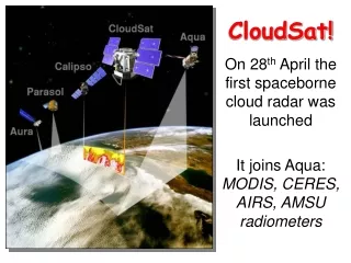
(Image from http://cloudsat.atmos.colostate.edu) Both AIRS and AMSR-E are aboard Aqua. COMPARISONS WITH CLOUDSAT Launched in 2006, CloudSat, with its Profiling Radar, flies in formation with the other satellites in the A-Train constellation. CloudSat views on a nadir track, providing a “curtain” of cloud/precip data at all latitudes.
Calibrated AIRS Original AIRS AMSR-E CALIBRATION WITH AMSR-E Assuming AMSR precipitation is correct--over ocean 9-10 July 2006, 22:30-01:30 UTC High-latitude Southern Hemisphere winter case, with precipitation near the center of the swath Original AIRS precipitation is too widespread in both high latitudes and the tropics. Calibrating to AMSR-E greatly reduces spatial coverage; rates are boosted closer to AMSR-E. Mapping via histogram-matching can be extreme, due to limited range of AIRS rain rates (max. ~1.2 mm/hr).
Calibrated AIRS Original AIRS AMSR-E CALIBRATION WITH AMSR-E (cont.) 26 July 2006, 04:27-05:10 UTC High-latitude Northern Hemisphere summer case, with precipitation near the center of the swath Original AIRS precipitation is too light and probably too widespread. Calibrating to AMSR-E reduces spatial coverage, but overestimates in the heaviest rain areas. Histogram-matching cannot “create” precipitation where it did not exist (e.g., the AMSR-E “tail”).
16 January 2004 mm/d 16 January 2004 mm/d Application of CALIBRATION WITH AMSR-E Example of AIRS filling in a feature over snow where AMSR cannot reliably estimate AMSR-E Land precip feature Calibrated AIRS
AIRS RH (%) 200 400 Pressure (hPa) 600 800 1000 COMPARISONS WITH CLOUDSAT 10 July 2006, ~00:00-00:06 UTC The A-train formation allows for nearly-coincident space/time match-ups between AIRS relative humidity profiles and CloudSat radar reflectivities. CloudSat Profiling Radar Good correspondence between high/saturated deep-layer AIRS RH and high/deep CloudSat reflectivities in the heart of the storm system. (61.7°S, 7.3°E) (41.0°S, 16.8°E)
AIRS RH (%) 200 400 Pressure (hPa) 600 800 1000 COMPARISONS WITH CLOUDSAT (cont.) 26 July 2006, ~04:24-04:30 UTC Excellent agreement between AIRS humidity profile and nearly- coincident CloudSat reflectivities, both in precipitating and non- precipitating clouds. CloudSat Profiling Radar ) Quality flags indicate a fall-back to the microwave scheme in deep clouds, where CloudSat indicates precipitation. (56.7°N, 30.8°W) (76.1°N, 5.1°W)
Ocean Precipitation Frequency from Various Satellite Estimates • All estimates (except GPCP Daily) are instantaneous; different footprint sizes and precipitation rate thresholds also complicate comparison • Preliminary results indicate Cloudsat estimates reasonable and useful for adjustment of other estimates--e.g. AIRS; but large difference among Cloudsat estimates • SSM/I and AMSR estimates fall off rapidly at high latitudes; HOAPS (SSM/I) better, but questionable at low latitude
Seasons • Cloudsat shows higher oceanic frequencies in winter (50-70° lat.); HOAPS agrees, other estimates do not • Cloudsat “snow possible” bigger in winter, especially in N.H. • HOAPS tropical features very different from AMSR and SSM/I • AMSR may have ice “problem” at higher latitudes in winter Winter Summer Winter Summer Currently working on time-space scale issues so we can better use Cloudsat and AMSR to determine “correct” fraction
Conclusions and Future • Research in progress--developing comparisons of various high latitude precipitation estimates and empirical AIRS/TOVS technique to merge multiple estimates for globally-complete, high-time resolution precipitation analysis • Cloudsat, AMSR and AIRS “simultaneity” key to much of analysis • Cloudsat precipitation estimates (from L’Ecuyer, Haynes--CSU) very useful--but need to develop techniques to compare with other estimates--with larger footprints (and 2-d)--also which “certain”, “probable” or “possible” versions • High latitude (especially land) precipitation still challenging--need many approaches and comparisons