1 / 0

History of Surveying Boundary Retracement Ron W. Householder, PLS, GISP

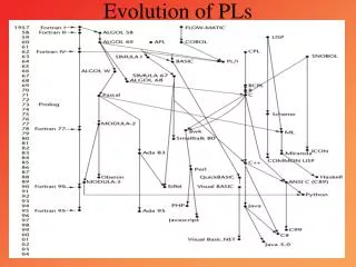
Kentucky GIS Conference September 30, 2013. History of Surveying Boundary Retracement Ron W. Householder, PLS, GISP . Overview. Context Definitions Retracement Surveyor as “Detective” History Ancient Development Common Law and Statutory Law Technology Evidence and Procedures

cricket
Download Presentation

History of Surveying Boundary Retracement Ron W. Householder, PLS, GISP

An Image/Link below is provided (as is) to download presentation Download Policy: Content on the Website is provided to you AS IS for your information and personal use and may not be sold / licensed / shared on other websites without getting consent from its author. Content is provided to you AS IS for your information and personal use only. Download presentation by click this link. While downloading, if for some reason you are not able to download a presentation, the publisher may have deleted the file from their server. During download, if you can't get a presentation, the file might be deleted by the publisher.

E N D

Presentation Transcript


  1. Kentucky GIS Conference September 30, 2013

    History of Surveying Boundary RetracementRon W. Householder, PLS, GISP

  2. Overview Context Definitions Retracement Surveyor as “Detective” History Ancient Development Common Law and Statutory Law Technology Evidence and Procedures Common Law Statutory Law Colonial and Public Lands Systems Conflicting elements in Boundary Location Summary The more things change, the more they stay the same!
  3. Context Definition Science and art of determining relative positions of points above, on or beneath the surface of the earth, or establishing such points. In a more specific real property sense, means and includes any services requiring the determination or location of land boundaries (including their subdivision) and land boundary corners and incidental topography and the preparation of maps. Boundary Surveying Research and analysis Field work and data acquisition Computation or data processing Mapping or data representation (description) Stakeout Retracement Follow the “footsteps” of the original surveyor
  4. History The oldest historical records indicate the beginnings of surveying originated in ancient Egypt (about 1400 B.C.) in a division of lands for the purpose of taxation. Greeks advanced theory and technology Geometry and the “Diopter” “Cursed be he that removeth his neighbor’s landmark. And all people shall say Amen.” Deut. 27:17 Romans continued advancement and spread knowledge thorough-out the empire Into France and England Arabs maintained knowledge base during “Dark Ages” We inherit our system primarily from the British We operate within a system of Rules Common Law Statutory Law
  5. History Over time the tools improve Science of measurement is an inexact science Better understanding of errors and error theory Random and Systematic Errors
  6. Evidence and Procedures Common Law Unwritten (Case Law) Case Law introduced and affirmed over and over may become Common Law Same weight as statutory Statutory Law Written 1st and 14th Amendments Critical Roles Application – Surveyor Surveyor must have understanding of both Common and Statutory Law Interpretation – Legal Lawyers and Judges
  7. Land Systems Colonial 13 Colonies and Texas Patents and Grants Generated $’s and created means to pay for military service Metes and Bounds First come first served Yielded irregular shaped parcels with gaps and overlaps Junior and Senior rights apply Public Lands Rectangular or Government Seven Ranges Survey (1785)
  8. Colonial Kentucky Colonial 1792 – KY created from a County of VA and granted statehood 1797 – Act of 1797 – Gave 10 months to hear cases then declared all titles “good” All title ultimately vested in the Commonwealth Metes and Bounds All of KY except for extreme Western portion of state Purchase Area – Rectangular but NOT truly Public Lands Statutory Law KRS 100 – Planning & Zoning Law KRS 322 – Registration Law Legal role of Surveyor Privileges Recognition (Expert Witness) Responsibilities Liability for errors
  9. Boundary Location Boundary is imaginary A legal abstraction Written description (Deed) is evidence of a Boundary Ownership is a collection (bundle) of rights Order of Importance of Conflicting Elements that Determine a Boundary Location: An unwritten right Senior right Written intention of the parties: Call for a survey Monuments Distance Direction Area Coordinates
  10. Summary… Tools and data sources change rapidly Laws evolve slowly over time For the Surveyor much is still the same… Research Deeds/Plats (Clerk’s Office) Subject property and adjoiners Ownership (PVA) Subject property and adjoiners Parole Evidence Field Survey Computations/Boundary Resolution Cogo Aerial, Topo, Historical Maps, Highway Plans, etc. Determine Boundary Location and Identify conflicts and report conflicts to client Surveyor ‘s job is APPLICATION of the Law, NOT INTERPRETATION Stakeout The Surveyor’s Quasi-Judicial Role Toga and sandals to GPS surveys and CAD/GIS The History “Detective”
More Related