Download
1 / 6
60 likes | 215 Views
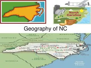
Geography of NC. Basic Facts. Located in the southeastern United States Bounded on the north by Virginia on the west by Tennessee on the south by Georgia and South Carolina on the east by Atlantic Ocean its longest east-west point is about 500 miles

E N D
Basic Facts • Located in the southeastern United States • Bounded • on the north by Virginia • on the west by Tennessee • on the south by Georgia and South Carolina • on the east by Atlantic Ocean • its longest east-west point is about 500 miles • its widest north-south point is about 180 miles • covers about 53,000squaremiles • is about the size of England • is known as one of the South Atlantic states
TIDEWATER • from the ocean to about 20-30 miles inland • contains a series of barrier islands that border the ocean known as the Outer Banks • Capes: (parts of the islands that jut far out into ocean): Cape Fear, Cape Lookout, Cape Hatteras (“Graveyard of the Atlantic”). In 1800’s lighthouses were built to help warn ships away from dangerous waters. • Sounds: (tide less body of water between barrier islands and mainland). • Major sounds are: Albemarle and Pamlico (LakeMattamuskeet is located between Pamlico & Albemarle Sounds) • Major Tidewater coastal towns -Morehead City & Wilmington
COASTAL PLAIN • located between Atlantic Ocean and the fall line • covers nearly 45% of state’s landmass • elevations range from sea level to 400-500 ft. at the fall line • stretches 70-100 miles from Tidewater to fall line • contains sandy soil—prime agricultural region • Main crops - tobacco, cotton, corn, wheat. • Beef & dairy cattle, hogs, & poultry- common livestock. • Sandhillsnamed because of deep sandy soil—noted for its golfcourses • Major Coastal Plain towns: Fayetteville & Southern Pines
PIEDMONT • located between the fall line and the Blue Ridge Mts. • stretches approximately 200 miles • covers nearly 39% of state’s landmass • elevations from 500-1,500 ft. (moving east to west) • Center of the state’s urban population • Major cities include: Raleigh (capital), Charlotte, Greensboro, Winston-Salem, Durham • Center of state’s manufacturing: textiles, tobacco, furniture • Before 1849, NC was the country’s leading gold producing state • (In Charlotte the federal government once minted gold coins) • Red clay soil--variety of products • Center of higher education (UNC, Duke, NC State) • Center of cultural activities (Museums, NC Zoo, Sports, etc)
MOUNTAINS • located between Piedmont and Tennessee • covers 6,000 square miles • elevations from 1,500(east) to 6,684 ft. • Mount Mitchell--highest peak in NC and eastern U.S. • about 200 miles long and 15-50 miles wide • part of Appalachian chain (runs southwest to northeast--from Georgia to Quebec) • Blue Ridge Mountains--at northeastern edge • Great Smokey Mountains --at southwestern edge • Asheville--largest city in region • Contains the state’s largest national forests (Pisgahand Nantahala