Download
1 / 48
490 likes | 513 Views
Test your knowledge of Latin America's physical features with questions on rivers, mountains, plateaus, and more. Learn about the diverse landscapes that shape this region.

E N D
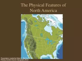
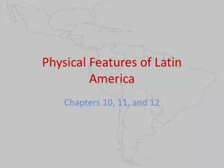
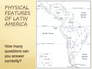
How many questions can you answer correctly? Physical Features of Latin America
What river cuts through the desert and forms a border between Mexico and the United States? Question #1
1,885 mile long river flowing across the southwestern United States and Mexico Most of the river is unnavigable due to its shallow, winding path through steep canyons Dams and reservoirs along the Rio Grande provide water for irrigation and drinking The Rio Grande River
What mountains in the western portion of South America run roughly parallel to the Pacific Coast for more than 5,000 miles? Question #2
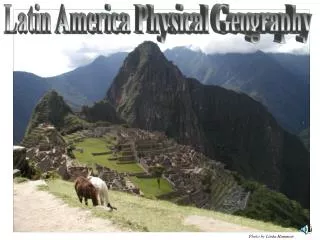
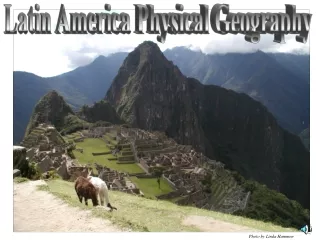
Stretch along the western edge of the entire continent of South America – world’s longest contiguous mt range Peruvian Andes hosts Machu Picchu, ruins of a sacred site for the Inca Home to Mt. Aconcagua, the highest mt of the western hemisphere Andes Mountains Mt. Aconcagua
What is the main mountain range in western Mexico that runs roughly parallel to the Pacific Coast? Question #3
The western part of the main mountain range of Mexico Extends from Arizona and parallels the Pacific Coast for about 1,000 miles Sierra madre occidental
What is the huge plateau that covers most of central Mexico and is surrounded by mountains? Question #4
700 miles long and 4,000 t0 8,000 ft high Enclosed by Sierra Madre Oriental to the east and the Sierra Madre Occidental to the west Plateau of mexico
What are the highlands in the northern portion of South America that separate Venezuela, Suriname, and French Guiana from Brazil? Question #5
Mountainous plateau covered with dense vegetation • Home to some of the world’s highest waterfalls • Tropical rainforest covers much of the highlands Guiana highlands
What is the large lake in the northern tip of South America that has a small opening into the Atlantic Ocean? Question #6
Located in northwest Venezuela and serves as a major transportation route Largest lake in South America – 5,100 square miles Lake maracaibo
What is the major river in the northern portion of South America that winds from the Guiana Highlands to the Atlantic Ocean? Question #7
It passes 1,500 to 1,700 miles through rainforests and savannas, ending in a marshy delta where it meets the Atlantic Ocean Most of the Orinoco is navigable and is used for shipping and transport vessels Orinoco river
What is the large peninsula in Mexico that extends into the Gulf of Mexico? Question #8
Separates the Gulf of Mexico from the Caribbean Sea Site of ancient Mayan ruins Tourist location – Cancun, Cozumel Yucatan peninsula
What is the long river in South America that winds from Peru through northern Brazil and empties into the Atlantic Ocean? Question #9
2ndlongest river in the world (1st- Nile) – 3,900 miles from Andes Mts to Atlantic Ocean • World’s largest river - carries more water than any other river in the world • Passes through the largest rainforest in the world Amazon river
What is the main mountain range in eastern Mexico that begins south of the Rio Grande? Question #10
The eastern part of the main mountain range of Mexico Begins just south of the Rio Grande near the U.S. border and runs southeast for 700 miles parallel to the coast of the Gulf of Mexico Sierra madre oriental
What lake is located high in the Andes Mountains and forms part of the border between Peru and Bolivia? Question #11
12,500 feet above sea level – one of the highest large lakes in the world Legendary birthplace of the Inca Lake titicaca
What is the plain that extends through northern Argentina, Paraguay, and southern Bolivia? Question #12
250,000 square miles of lowland plain Land is dry, becoming swampy during the rainy season Sparsely populated Gran chaco
What is the plateau located in southern Argentina between the Andes Mountains and the Atlantic Ocean? Question #13
300,000 square miles, primarily in southern Argentina Wide, semi-arid plateau Principal industry is sheep-raising for wool patagonia
What is the plain that covers most of central Argentina? Question #14
300,000 square miles of wide grassy plains used for cattle grazing and agriculture pampas
What is the desert located in northern Chile that is bordered by the Pacific Ocean to the west and the Andes Mountains to the east? Question #15
600 miles long – virtually no vegetation Some parts have never received measurable rainfall Atacama desert
Nazca Lines • Mysterious ancient lines and geoglyphs in the desert of Peru – discovered in 1927 • Were they made by aliens? Ancient cultures? • Want to learn more? Watch this: http://www.youtube.com/watch?v=I5q-T8PJu2c
What is the vast river basin that covers most of northern Brazil and parts of Bolivia, Peru, Ecuador, Colombia, and Venezuela? Question #16
Huge area (35% of S. Amer) in which water funnels into the Amazon River • Immense rainforest covers most of the basin – scientists estimate it supplies half of the world’s oxygen Amazon basin
What is the large lake located in southwest Nicaragua that drains into the Caribbean Sea? Question #17
Largest lake in Central America Was once part of the sea and formed when the land rose Contains several small islands and volcanoes Fish commonly found only in saltwater, such as tuna and sharks, adapted to freshwater of Lake Nicaragua Lake nicaragua
What is the estuary (place where a river meets the sea) on the southeast coast of South America formed by the meeting of the Parana and Uruguay Rivers? Question #18
170 miles long, empties into Atlantic Ocean Capital cities of Buenos Aires, Argentina and Montevideo, Uruguay are located along the Rio de la Plata Rio de la plata
What is the archipelago (chain of islands) located at the southern tip of South America and divided between Chile and Argentina? Question #19
Separated from the mainland of South America by the Strait of Magellan Narrow waterways between the islands of the archipelago are treacherous to navigate Tierra del fuego
What is the isthmus (narrow strip of land) that connects Central and South America? Question #20
Isthmus of Panama • Only about 40 miles wide • Hosts the Panama Canal, a waterway built by the US to connect the Caribbean Sea and Pacific Ocean
What is the name of the islands west of Ecuador on the equator? Who owns them? Other notable features:
Galapago islands • An archipelago of 11 volcanic islands distributed around the equator in the Pacific Ocean • Part of Ecuador • Known for their tortoises and scientific studies of plants and animals (Darwin)
What is the name of the islands east of southern Argentina? Who owns them? Other notable features:
Falkland islands • An archipelago in the South Atlantic Ocean • Territory of the United Kingdom • Argentina invaded and tried to claim but was defeated
What is the name of the sea route immediately south of mainland South America and north of Tierra del Fuego? Other notable features:
Strait of Magellan • Important natural water passage between Pacific and Atlantic Oceans • First discovered by Portuguese sailor Magellan • Difficult to navigate because of unpredictable winds and currents and narrowness of passage